Watches, Warnings & Advisories for Sunflower Co.

Tuesday, May 31, 2011

Heat Related Illness & Injury information

Heat kills by pushing the human body beyond its limits. In extreme heat and high humidity, evaporation is slowed and the body must work extra hard to maintain a normal temperature.

Most heat disorders occur because the victim has been overexposed to heat or has over-exercised for his or her age and physical condition. Older adults, young children, and those who are sick or overweight are more likely to succumb to extreme heat.

Conditions that can induce heat-related illnesses include stagnant atmospheric conditions and poor air quality.

Consequently, people living in urban areas may be at greater risk from the effects of a prolonged heat wave than those living in rural areas. Also, asphalt and concrete store heat longer and gradually release heat at night, which can produce higher nighttime temperatures known as the “urban heat island effect.”

Know the Terms
Familiarize yourself with these terms to help identify an extreme heat hazard:


Heat Wave
Prolonged period of excessive heat, often combined with excessive humidity.

Heat Index
A number in degrees Fahrenheit (F) that tells how hot it feels when relative humidity is added to the air temperature. Exposure to full sunshine can increase the heat index by 15 degrees.

Heat Cramps
Muscular pains and spasms due to heavy exertion. Although heat cramps are the least severe, they are often the first signal that the body is having trouble with the heat.

Heat Exhaustion
Typically occurs when people exercise heavily or work in a hot, humid place where body fluids are lost through heavy sweating. Blood flow to the skin increases, causing blood flow to decrease to the vital organs. This results in a form of mild shock. If not treated, the victim’s condition will worsen. Body temperature will keep rising and the victim may suffer heat stroke.

Heat Stroke
A life-threatening condition. The victim’s temperature control system, which produces sweating to cool the body, stops working. The body temperature can rise so high that brain damage and death may result if the body is not cooled quickly.

Sun Stroke
Another term for heat stroke.

Take Protective Measures
Before Extreme Heat
To prepare for extreme heat, you should:
  • Install window air conditioners snugly; insulate if necessary.
  • Check air-conditioning ducts for proper insulation.
  • Install temporary window reflectors (for use between windows and drapes), such as aluminum foil-covered cardboard, to reflect heat back outside.
  • Weather-strip doors and sills to keep cool air in.
  • Cover windows that receive morning or afternoon sun with drapes, shades, awnings, or louvers. (Outdoor awnings or louvers can reduce the heat that enters a home by up to 80 percent.)
  • Keep storm windows up all year.
During a Heat Emergency
The following are guidelines for what you should do if the weather is extremely hot:
  • Stay indoors as much as possible and limit exposure to the sun.
  • Stay on the lowest floor out of the sunshine if air conditioning is not available.
  • Consider spending the warmest part of the day in public buildings such as libraries, schools, movie theaters, shopping malls, and other community facilities. Circulating air can cool the body by increasing the perspiration rate of evaporation.
  • Eat well-balanced, light, and regular meals. Avoid using salt tablets unless directed to do so by a physician.
  • Drink plenty of water. Persons who have epilepsy or heart, kidney, or liver disease; are on fluid-restricted diets; or have a problem with fluid retention should consult a doctor before increasing liquid intake.
  • Limit intake of alcoholic beverages.
  • Dress in loose-fitting, lightweight, and light-colored clothes that cover as much skin as possible.
  • Protect face and head by wearing a wide-brimmed hat.
  • Check on family, friends, and neighbors who do not have air conditioning and who spend much of their time alone.
  • Never leave children or pets alone in closed vehicles.
  • Avoid strenuous work during the warmest part of the day. Use a buddy system when working in extreme heat, and take frequent breaks.
First Aid for Heat-Induced Illnesses
Condition, Symptoms, and First Aid

Sunburn Skin redness and pain, possible swelling, blisters, fever, headaches.  Take a shower using soap to remove oils that may block pores, preventing the body from cooling naturally.  Apply dry, sterile dressings to any blisters, and get medical attention.

Heat Cramps Painful spasms, usually in leg and abdominal muscles; heavy sweating Get the victim to a cooler location.  Lightly stretch and gently massage affected muscles to relieve spasms.  Give sips of up to a half glass of cool water every 15 minutes. (Do not give liquids with caffeine or alcohol.)  Discontinue liquids, if victim is nauseated.

Heat Exhaustion Heavy sweating but skin may be cool, pale, or flushed. Weak pulse. Normal body temperature is possible, but temperature will likely rise. Fainting or dizziness, nausea, vomiting, exhaustion, and headaches are possible. Get victim to lie down in a cool place.  Loosen or remove clothing.  Apply cool, wet clothes.  Fan or move victim to air-conditioned place.  Give sips of water if victim is conscious.  Be sure water is consumed slowly.  Give half glass of cool water every 15 minutes.  Discontinue water if victim is nauseated.  Seek immediate medical attention if vomiting occurs.

Heat Stroke  (a severe medical emergency) High body temperature (105+); hot, red, dry skin; rapid, weak pulse; and rapid shallow breathing. Victim will probably not sweat unless victim was sweating from recent strenuous activity. Possible unconsciousness. Call 9-1-1 or emergency medical services, or get the victim to a hospital immediately. Delay can be fatal.  Move victim to a cooler environment.  Removing clothing  Try a cool bath, sponging, or wet sheet to reduce body temperature.  Watch for breathing problems.  Use extreme caution.  Use fans and air conditioners.

 
***DO NOT USE THIS WEBSITE AS YOUR SOLE SOURCE OF WEATHER INFORMATION, ESPECIALLY WATCHES AND WARNINGS. THIS WEBSITE DELIVERS FOCUSED INFORMATION FOR A SPECIFIC GEOGRAPHIC AREA AND IS NOT INTENDED TO PROVIDE TIMELY WEATHER WARNING INFORMATION***

First Heat Wave 2011

Heat indexes this week will approach levels requiring caution when participating in outdoor activities.  Please stay informed as the week progresses.  Short outdoor work periods and proper hydration can help with heat stress.  

More information on how to prepare for, and manage heat-related emergencies can be found by clicking here.


This Afternoon: Mostly sunny, with a high near 94. South southeast wind around 5 mph.

Tonight: Mostly clear, with a low around 71. East southeast wind around 5 mph becoming calm.

Wednesday: Sunny and hot, with a high near 97. Heat index values as high as 101. East northeast wind around 5 mph.

Wednesday Night: Partly cloudy, with a low around 73. North northeast wind around 5 mph.

Thursday: Sunny and hot, with a high near 100. Calm wind becoming east around 5 mph.

Thursday Night: Clear, with a low around 73. East southeast wind around 5 mph becoming calm.

Friday: Sunny and hot, with a high near 97. South wind around 5 mph.

Friday Night: Clear, with a low around 72. East southeast wind around 5 mph becoming calm.

Saturday: A 20 percent chance of showers and thunderstorms. Sunny, with a high near 95. Calm wind becoming northeast between 5 and 10 mph.

Saturday Night: A 20 percent chance of showers and thunderstorms. Mostly clear, with a low around 70.

Sunday: A 30 percent chance of showers and thunderstorms. Sunny, with a high near 93.

Sunday Night: A 20 percent chance of showers and thunderstorms. Clear, with a low around 72.

Monday: A 20 percent chance of showers and thunderstorms. Sunny, with a high near 95. 

Weds-Thursday Temperature & Heat Index Projection
Friday-Saturday Temperature & Heat Index Projection


***DO NOT USE THIS WEBSITE AS YOUR SOLE SOURCE OF WEATHER INFORMATION, ESPECIALLY WATCHES AND WARNINGS. THIS WEBSITE DELIVERS FOCUSED INFORMATION FOR A SPECIFIC GEOGRAPHIC AREA AND IS NOT INTENDED TO PROVIDE TIMELY WEATHER WARNING INFORMATION***

Wednesday, May 25, 2011

Hazardous Weather Outlook for Tonight/Tomorrow

HAZARDOUS WEATHER OUTLOOK
NATIONAL WEATHER SERVICE JACKSON MS
600 AM CDT WED MAY 25 2011

ARZ074-075-LAZ007>009-015-MSZ018-019-025-034-035-040-041-261100-
ASHLEY-CHICOT-MOREHOUSE-WEST CARROLL-EAST CARROLL-RICHLAND-
BOLIVAR-SUNFLOWER-LEFLORE-WASHINGTON-HUMPHREYS-ISSAQUENA-SHARKEY-
600 AM CDT WED MAY 25 2011

THIS HAZARDOUS WEATHER OUTLOOK IS FOR CENTRAL MISSISSIPPI...
NORTHEAST LOUISIANA...AND EXTREME SOUTHEAST ARKANSAS.

.DAY ONE...TODAY AND TONIGHT

A SEVERE WEATHER OUTBREAK IS POSSIBLE LATE THIS AFTERNOON AND EVENING
AS AN UNSEASONABLY STRONG LOW PRESSURE SYSTEM MOVES ACROSS THE
MISSISSIPPI VALLEY. SEVERE THUNDERSTORMS CAPABLE OF PRODUCING
DAMAGING WIND GUSTS UP TO 70 MPH...VERY LARGE HAIL TO THE SIZE OF
TENNIS BALLS...AND A FEW TORNADOES...WILL LIKELY DEVELOP AND IMPACT
UPPER PORTIONS OF THE ARKLAMISS DELTA REGION.

IN ADDITION...LOCALLY HEAVY RAINFALL IS POSSIBLE DURING THIS TIME AND
COULD RAISE CONCERNS FOR FLASH FLOODING. THE RISK FOR SEVERE WEATHER
SHOULD DECREASE AND COME TO AN END BY THURSDAY MORNING. ALL RESIDENTS
ACROSS THE OUTLOOK AREA SHOULD STAY TUNED TO THE LATEST FORECASTS AND
OUTLOOKS CONCERNING THIS POTENTIAL SEVERE WEATHER OUTBREAK.

A WIND ADVISORY IS IN EFFECT FOR THE DELTA REGION FROM LATE MORNING
THROUGH THE AFTERNOON. SOUTHERLY WINDS MAY GUST UP TO 40 MPH AHEAD OF
THE STORM SYSTEM...ESPECIALLY ALONG THE MISSISSIPPI RIVER.

.DAYS TWO THROUGH SEVEN...THURSDAY THROUGH TUESDAY

THE PROBABILITY FOR WIDESPREAD HAZARDOUS WEATHER IS LOW.

.SPOTTER CALL TO ACTION STATEMENT...
THE ACTIVATION OF STORM SPOTTERS...HAM RADIO OPERATORS...AND
EMERGENCY MANAGEMENT PERSONNEL IN SUPPORT OF SEVERE WEATHER
OPERATIONS WILL PROBABLY BE NECESSARY LATE THIS AFTERNOON AND
EVENING.


***DO NOT USE THIS WEBSITE AS YOUR SOLE SOURCE OF WEATHER INFORMATION, ESPECIALLY WATCHES AND WARNINGS. THIS WEBSITE DELIVERS FOCUSED INFORMATION FOR A SPECIFIC GEOGRAPHIC AREA AND IS NOT INTENDED TO PROVIDE TIMELY WEATHER WARNING INFORMATION***

Tuesday, May 24, 2011

Update on Weds/Thurs Weather outlook

HAZARDOUS WEATHER OUTLOOK...UPDATED
NATIONAL WEATHER SERVICE JACKSON MS
745 PM CDT MON MAY 23 2011

THIS HAZARDOUS WEATHER OUTLOOK IS FOR PORTIONS OF CENTRAL
MISSISSIPPI...NORTHEAST LOUISIANA...AND EXTREME SOUTHEAST ARKANSAS.

.DAY ONE...TONIGHT AND TUESDAY

THE PROBABILITY FOR WIDESPREAD HAZARDOUS WEATHER IS LOW.

.DAYS TWO THROUGH SEVEN...TUESDAY NIGHT THROUGH SUNDAY

A STRONG LOW PRESSURE SYSTEM CROSSING THE MISSISSIPPI VALLEY WILL
BRING A RISK OF SEVERE THUNDERSTORMS AND HEAVY RAINFALL TO NORTHERN
PORTIONS OF THE ARKLAMISS STARTING LATE WEDNESDAY AFTERNOON...AND
CONTINUING THROUGH THE DAY THURSDAY. ALL INTERESTS IN THE ARKLAMISS
SHOULD STAY TUNED TO THE LATEST FORECASTS AND OUTLOOKS CONCERNING
THIS POTENTIAL.

.SPOTTER CALL TO ACTION STATEMENT...
THE ACTIVATION OF STORM SPOTTERS...HAM RADIO OPERATORS...AND
EMERGENCY MANAGEMENT PERSONNEL IN SUPPORT OF SEVERE WEATHER
OPERATIONS MAY BE NEEDED LATE WEDNESDAY AND THURSDAY.


***DO NOT USE THIS WEBSITE AS YOUR SOLE SOURCE OF WEATHER INFORMATION, ESPECIALLY WATCHES AND WARNINGS. THIS WEBSITE DELIVERS FOCUSED INFORMATION FOR A SPECIFIC GEOGRAPHIC AREA AND IS NOT INTENDED TO PROVIDE TIMELY WEATHER WARNING INFORMATION***

Hazardous Weather Outlook Update

HAZARDOUS WEATHER OUTLOOK
NATIONAL WEATHER SERVICE JACKSON MS
559 AM CDT TUE MAY 24 2011

THIS HAZARDOUS WEATHER OUTLOOK IS FOR CENTRAL MISSISSIPPI...
NORTHEAST LOUISIANA...AND EXTREME SOUTHEAST ARKANSAS.

.DAY ONE...TODAY AND TONIGHT

THE PROBABILITY FOR WIDESPREAD HAZARDOUS WEATHER IS LOW.

.DAYS TWO THROUGH SEVEN...WEDNESDAY THROUGH MONDAY

A SEVERE WEATHER OUTBREAK IS POSSIBLE LATE WEDNESDAY AFTERNOON AND
EVENING AS AN UNSEASONABLY STRONG LOW PRESSURE SYSTEM MOVES ACROSS
THE MISSISSIPPI VALLEY. SEVERE THUNDERSTORMS CAPABLE OF PRODUCING
DAMAGING WIND GUSTS UP TO 70 MPH...VERY LARGE HAIL TO THE SIZE OF
TENNIS BALLS...AND A FEW TORNADOES...WILL LIKELY DEVELOP AND IMPACT
UPPER PORTIONS OF THE ARKLAMISS DELTA REGION. IN ADDITION...HEAVY
RAINFALL IS LIKELY AND THIS COULD RAISE CONCERNS FOR FLASH FLOODING.
THE RISK FOR SEVERE WEATHER SHOULD DECREASE AND COME TO AN END
THURSDAY MORNING. ALL INTERESTS SHOULD STAY TUNED TO THE LATEST
FORECASTS AND OUTLOOKS CONCERNING THIS POTENTIAL SEVERE WEATHER
OUTBREAK.

.SPOTTER CALL TO ACTION STATEMENT...
THE ACTIVATION OF STORM SPOTTERS...HAM RADIO OPERATORS...AND
EMERGENCY MANAGEMENT PERSONNEL IN SUPPORT OF SEVERE WEATHER
OPERATIONS MAY BE NECESSARY FROM LATE WEDNESDAY AFTERNOON THROUGH
WEDNESDAY NIGHT.


***DO NOT USE THIS WEBSITE AS YOUR SOLE SOURCE OF WEATHER INFORMATION, ESPECIALLY WATCHES AND WARNINGS. THIS WEBSITE DELIVERS FOCUSED INFORMATION FOR A SPECIFIC GEOGRAPHIC AREA AND IS NOT INTENDED TO PROVIDE TIMELY WEATHER WARNING INFORMATION***

Monday, May 23, 2011

Hazardous Weather Outlook for May 25/26, 2011

HAZARDOUS WEATHER OUTLOOK...UPDATED
NATIONAL WEATHER SERVICE JACKSON MS
745 PM CDT MON MAY 23 2011

THIS HAZARDOUS WEATHER OUTLOOK IS FOR PORTIONS OF CENTRAL
MISSISSIPPI...NORTHEAST LOUISIANA...AND EXTREME SOUTHEAST ARKANSAS.

.DAY ONE...TONIGHT AND TUESDAY

THE PROBABILITY FOR WIDESPREAD HAZARDOUS WEATHER IS LOW.

.DAYS TWO THROUGH SEVEN...TUESDAY NIGHT THROUGH SUNDAY

A STRONG LOW PRESSURE SYSTEM CROSSING THE MISSISSIPPI VALLEY WILL
BRING A RISK OF SEVERE THUNDERSTORMS AND HEAVY RAINFALL TO NORTHERN
PORTIONS OF THE ARKLAMISS STARTING LATE WEDNESDAY AFTERNOON...AND
CONTINUING THROUGH THE DAY THURSDAY. ALL INTERESTS IN THE ARKLAMISS
SHOULD STAY TUNED TO THE LATEST FORECASTS AND OUTLOOKS CONCERNING
THIS POTENTIAL.

.SPOTTER CALL TO ACTION STATEMENT...
THE ACTIVATION OF STORM SPOTTERS...HAM RADIO OPERATORS...AND
EMERGENCY MANAGEMENT PERSONNEL IN SUPPORT OF SEVERE WEATHER
OPERATIONS MAY BE NEEDED LATE WEDNESDAY AND THURSDAY.


***DO NOT USE THIS WEBSITE AS YOUR SOLE SOURCE OF WEATHER INFORMATION, ESPECIALLY WATCHES AND WARNINGS. THIS WEBSITE DELIVERS FOCUSED INFORMATION FOR A SPECIFIC GEOGRAPHIC AREA AND IS NOT INTENDED TO PROVIDE TIMELY WEATHER WARNING INFORMATION***

Thursday, May 12, 2011

MS River forecast update 5/12/11

 
***DO NOT USE THIS WEBSITE AS YOUR SOLE SOURCE OF WEATHER INFORMATION, ESPECIALLY WATCHES AND WARNINGS. THIS WEBSITE DELIVERS FOCUSED INFORMATION FOR A SPECIFIC GEOGRAPHIC AREA AND IS NOT INTENDED TO PROVIDE TIMELY WEATHER WARNING INFORMATION***

Hazardous Weather Outlook - 5/12/2011

HAZARDOUS WEATHER OUTLOOK
NATIONAL WEATHER SERVICE JACKSON MS
718 AM CDT THU MAY 12 2011

THIS HAZARDOUS WEATHER OUTLOOK IS FOR CENTRAL MISSISSIPPI...
NORTHEAST LOUISIANA...AND EXTREME SOUTHEAST ARKANSAS.

.DAY ONE...TODAY AND TONIGHT

THUNDERSTORMS MAY DEVELOP AHEAD OF A SLOW MOVING COLD FRONT LATE THIS
AFTERNOON INTO THE OVERNIGHT HOURS...MAINLY AFFECTING LOCATIONS ALONG
AND WEST OF THE MISSISSIPPI RIVER. A FEW OF THESE THUNDERSTORMS WILL
HAVE THE POTENTIAL TO BECOME STRONG TO SEVERE WITH LARGE HAIL BEING
THE PRIMARY CONCERN. LOCALLY HEAVY RAINFALL WILL BE A CONCERN AS
ADDITIONAL RAINFALL ACROSS THE DELTA REGION WILL ONLY AGGRAVATE
ONGOING FLOODING ISSUES IN BACKWATER AREAS.

.DAYS TWO THROUGH SEVEN...FRIDAY THROUGH WEDNESDAY

ADDITIONAL STRONG TO SEVERE THUNDERSTORMS ARE EXPECTED TO DEVELOP
FRIDAY FOR THE ENTIRE OUTLOOK AREA ALONG THE FRONT AS IT SLOWLY
SHIFTS EAST. THE PRIMARY HAZARDS WILL AGAIN BE HAIL UP TO GOLFBALL
SIZE AND DAMAGING WINDS UP TO 60 MPH. LOCALLY HEAVY RAINFALL WILL
ALSO BE POSSIBLE.

.SPOTTER CALL TO ACTION STATEMENT...
THE ACTIVATION OF STORM SPOTTERS...HAM RADIO OPERATORS...AND
EMERGENCY MANAGEMENT PERSONNEL IN SUPPORT OF SEVERE WEATHER
OPERATIONS...MAY BE NEEDED LATER TODAY AND AGAIN ON FRIDAY.


***DO NOT USE THIS WEBSITE AS YOUR SOLE SOURCE OF WEATHER INFORMATION, ESPECIALLY WATCHES AND WARNINGS. THIS WEBSITE DELIVERS FOCUSED INFORMATION FOR A SPECIFIC GEOGRAPHIC AREA AND IS NOT INTENDED TO PROVIDE TIMELY WEATHER WARNING INFORMATION***

Sunday, May 8, 2011

MS River Crest Dates 5/8/2011

Updated Mississippi River forecast crest dates.  Crest levels have not changed in this forecast, dates have changed slightly for various gages.


***DO NOT USE THIS WEBSITE AS YOUR SOLE SOURCE OF WEATHER INFORMATION, ESPECIALLY WATCHES AND WARNINGS. THIS WEBSITE DELIVERS FOCUSED INFORMATION FOR A SPECIFIC GEOGRAPHIC AREA AND IS NOT INTENDED TO PROVIDE TIMELY WEATHER WARNING INFORMATION***

Anticipated Road Closures & Dates

Click here for a May 8, 2011 press release from the Mississippi Joint Information Center concerning anticipated road closures in the South Delta area.  Closures of major highways may begin this weekend, and will require considerable detours to travel to the Jackson area from the upper Delta area.

***DO NOT USE THIS WEBSITE AS YOUR SOLE SOURCE OF WEATHER INFORMATION, ESPECIALLY WATCHES AND WARNINGS. THIS WEBSITE DELIVERS FOCUSED INFORMATION FOR A SPECIFIC GEOGRAPHIC AREA AND IS NOT INTENDED TO PROVIDE TIMELY WEATHER WARNING INFORMATION***

Thursday, May 5, 2011

MS River Flood Map update 5/5/2011

From the US Corps of Engineers, Vicksburg District:


***DO NOT USE THIS WEBSITE AS YOUR SOLE SOURCE OF WEATHER INFORMATION, ESPECIALLY WATCHES AND WARNINGS. THIS WEBSITE DELIVERS FOCUSED INFORMATION FOR A SPECIFIC GEOGRAPHIC AREA AND IS NOT INTENDED TO PROVIDE TIMELY WEATHER WARNING INFORMATION***

Wednesday, May 4, 2011

MS River Flooding update May 4, 2011

Not a lot of new information to report today on the Mississippi River Flooding situation.  They've changed the crest dates, as illustrated in the graphic below.


***DO NOT USE THIS WEBSITE AS YOUR SOLE SOURCE OF WEATHER INFORMATION, ESPECIALLY WATCHES AND WARNINGS. THIS WEBSITE DELIVERS FOCUSED INFORMATION FOR A SPECIFIC GEOGRAPHIC AREA AND IS NOT INTENDED TO PROVIDE TIMELY WEATHER WARNING INFORMATION***

Tuesday, May 3, 2011

MS River Flooding Map Updates

I found these projection maps posted on the National Weather Service - Jackson, MS website.  Again, you are strongly urged to use these ONLY as a planning tool.  The final outcome could be different than these maps project.  This is the link to the page referenced. 
http://www.srh.noaa.gov/jan/?n=2011_05_ms_river_flood

Again, use these maps as a tool for planning and preparedness.  This website is not about making predictions.  We're here to keep you informed so you can be prepared.


***DO NOT USE THIS WEBSITE AS YOUR SOLE SOURCE OF WEATHER INFORMATION, ESPECIALLY WATCHES AND WARNINGS. THIS WEBSITE DELIVERS FOCUSED INFORMATION FOR A SPECIFIC GEOGRAPHIC AREA AND IS NOT INTENDED TO PROVIDE TIMELY WEATHER WARNING INFORMATION***

MS River Flooding Update May 3, 2011

First, everyone take a deep breath.

The river stage forecasts have not changed today.  They are as follows:

Arkansas City: 53.5' crest on 5/14/2011
Greenville: 64.5' crest on 5/15/2011
Vicksburg 57.5' crest on 5/18/2011

This forecast will exceed 1973 flood levels by 6 feet.  This forecast puts us 3.5 feet above the 100-year flood on the Mississippi River.  The 100-year flood on the Mississippi River is 61 feet at Greenville, and 54 feet at Vicksburg.

The Mississippi River Levee road will be closed starting Saturday night at midnight.  Only Levee Board employees, Corps of Engineers members, Highway Inspectors, Game Wardens and Law Enforcement officers will be allowed on the levee.  Anyone else will be arrested.

There is a great deal of discussion on what may or may not actually happen.  I can tell you with a great degree of confidence (based on a lot of experience), don't take any statements of what will happen at face value.  Always approach them with a degree of skepticism.  Your best bet is to take all of the projections and find the average of all of them.  Even then, keep the worst-case-scenario in mind.

One school of thought, the worst-case-scenario, estimates the worst Yazoo River backwater could reach ground elevations of 107-109 feet above mean sea level.  The best-case scenario limits flooding to 94-96 feet above mean sea level.  That means, if you've got Mississippi Delta property below around 95 feet above sea level, you can expect water.  But, it does NOT rule out the possibility of flooding up to the 107-109 foot level.

New maps are being worked on that illustrate these various levels.  I'll try to post them whenever I can.

I want to encourage you to consider two major schools of thought on what to expect.  They are: 1) What is possible, and 2) What is most likely.

The possibilities include massive widespread flooding as was illustrated in the maps posted yesterday.  I personally don't expect to see that.  But it cannot be ruled out.

The second line of thinking...what is most likely...  Greenville, Greenwood, Indianola, Cleveland and other towns in the area can expect to see an influx of evacuees from the flooded areas.    Extra, temporary residents will create a greater demand on all aspects of infrastructure: commerce (hotels, shopping, food), utilities (water, power), and public services (healthcare, fire, ambulance, etc).

We would be prudent to begin planning now on how to best help these evacuees. 

I cannot stress enough, that this is a dynamic situation.  It is not like an approaching hurricane or thunderstorm that we can fairly accurately predict.  Final Mississippi River levels, levee integrity, future rainfall prior to and during the flood, land contouring over the past decades, road bed levels, and a host of other variables influence where water will finally end up.  Just remember this isn't the Delta's first dance with the Father of Waters, nor will it be the last.  None of us are invulnerable to flooding.  Take time now to consider the adequacy of your family's disaster plans.  And be willing to lend a hand to our neighbors that may be visiting for a while.


***DO NOT USE THIS WEBSITE AS YOUR SOLE SOURCE OF WEATHER INFORMATION, ESPECIALLY WATCHES AND WARNINGS. THIS WEBSITE DELIVERS FOCUSED INFORMATION FOR A SPECIFIC GEOGRAPHIC AREA AND IS NOT INTENDED TO PROVIDE TIMELY WEATHER WARNING INFORMATION***
Flood Warning Statement


FLOOD STATEMENT
NATIONAL WEATHER SERVICE JACKSON, MS
1117 PM CDT MON MAY 2 2011


...THE FLOOD WARNING CONTINUES FOR THE FOLLOWING RIVERS IN
   ARKANSAS...MISSISSIPPI...LOUISIANA..

  *MISSISSIPPI RIVER NEAR ARKANSAS CITY AFFECTING CHICOT...DESHA...
   BOLIVAR AND WASHINGTON COUNTIES

  *MISSISSIPPI RIVER NEAR GREENVILLE AFFECTING CHICOT...EAST
   CARROLL...ISSAQUENA AND WASHINGTON COUNTIES

  *MISSISSIPPI RIVER AT VICKSBURG AFFECTING MADISON...TENSAS...
   CLAIBORNE...JEFFERSON AND WARREN COUNTIES/PARISHES

  *MISSISSIPPI RIVER AT NATCHEZ AFFECTING CONCORDIA...ADAMS AND
   WILKINSON COUNTIES/PARISHES

SYSNOPSIS...

RECORD FLOODING IS EXPECTED FROM VICKSBURG TO NATCHEZ. OVER THE
LAST 48 HOURS...RAINFALL FROM 3 TO 10 INCHES HAS OCCURRED FROM
SOUTHWEST THROUGH CENTRAL ARKANSAS AND INTO WEST TENNESSEE.
ALSO, RAINFALL FROM 3 TO 8 INCHES HAS OCCURRED FROM NORTH ARKANSAS
ACROSS THE MISSOURI BOOTHEEL AND OVER CAIRO ILLINOIS AND UP THE
OHIO RIVER VALLEY. THIS RAINFALL HAS FALLEN ON ALREADY SWOLLEN OHIO...
MISSISSIPPI...ARKANSAS...AND WHITE RIVERS. THE LOWER OHIO RIVER
AT CAIRO HAS SURGED UPWARD TODAY AND IS EXPECTED TO CREST AT
63.0 FEET ON MAY 5TH. THE CREST FORECAST FOR THE MISSISSIPPI
RIVER FROM ARKANSAS CITY TO GREENVILLE HAS BEEN RAISED 4 TO 5 FEET.
THIS IS BELOW THE FLOOD OF 1927 AND THE FLOOD OF 1937 AT ARKANSAS
CITY. THE CREST AT GREENVILLE IS BELOW THE FLOOD OF 1927 BUT IS ABOVE
THE FLOOD OF 1937. WE WILL HAVE RECORD RIVER CRESTS FROM VICKSBURG
TO NATCHEZ. BACKWATER FLOODING ALONG THE YAZOO RIVER WILL INCREASE
SIGNIFICANTLY. WE ARE OVER TWO WEEKS AWAY FROM THE CURRENT RIVER
CRESTS AND THERE WILL BE A POTENTIAL FOR ADDITIONAL RAINFALL
ACROSS ARKANSAS INTO MISSOURI AND UP THE OHIO RIVER VALLEY. PLEASE
STAY INFORMED OVER THE 2 TO 3 WEEKS.

PRECAUTIONARY/PREPAREDNESS ACTIONS...

DO NOT DRIVE OR WALK THROUGH AREAS WHERE WATER COVERS ROADWAYS! THE
WATER MAY BE DEEPER THAN IT APPEARS. PLEASE USE EXTREME CAUTION IF
VENTURING NEAR RIVERBANKS. MOVE TO HIGHER GROUND IMMEDIATELY SHOULD
RISING WATER THREATEN YOUR SAFETY. REMEMBER...TURN AROUND, DON`T
DROWN!

THE FORECASTS ARE BASED ON RAINFALL THAT HAS OCCURRED AND THAT WHICH
IS FORECAST TO OCCUR OVER THE NEXT 12 HOURS.

THE NEXT REGULARLY SCHEDULED UPDATE IS EXPECTED BETWEEN 8 AND 10 AM.

&&

ARC017-041-MSC011-151-041017-
/O.CON.KJAN.FL.W.0046.000000T0000Z-000000T0000Z/
/ARSA4.3.ER.110428T1037Z.110514T1200Z.000000T0000Z.NO/
1117 PM CDT MON MAY 2 2011


THE FLOOD WARNING CONTINUES FOR THE MISSISSIPPI RIVER NEAR ARKANSAS CITY
* UNTIL FURTHER NOTICE.
* AT 10:00 PM MONDAY THE STAGE WAS 42.4 FEET.
* MODERATE FLOODING IS OCCURRING AND MAJOR FLOODING IS FORECAST.
* FLOOD STAGE IS 37.0 FEET.
* FORECAST...THE RIVER WILL CONTINUE RISING TO NEAR 53.5 FEET BY
  SATURDAY..MAY 14TH.
* IMPACT...AT 44.0 FEET...WATER IS ON THE LEVEES IN THE ARKANSAS CITY
  AREA. TRAILERS EVACUATED FROM THE HUNTING CLUB ON HUNTINGTON POINT
  MISSISSIPPI DUE TO HIGH WATER. ALL OF THE LAND INSIDE LEVEE
  PROTECTION IS INUNDATED.

&&

              FLOOD    OBSERVED        FORECAST 6AM       CREST
LOCATION       STG   STG DAY  TIME   TUE   WED   THU CREST DAY  TIME

LOWER MISSISSIPPI RIVER
ARKANSAS CITY   37  42.4 MON 10 PM  43.1  44.3  45.6  53.5    5/14

$$

THE FLOOD WARNING CONTINUES FOR THE MISSISSIPPI RIVER NEAR GREENVILLE
* UNTIL FURTHER NOTICE.
* AT 10:00 PM MONDAY THE STAGE WAS 53.5 FEET.
* MODERATE FLOODING IS OCCURRING AND MAJOR FLOODING IS FORECAST.
* FLOOD STAGE IS 48.0 FEET.
* FORECAST...THE RIVER WILL CONTINUE RISING TO NEAR 64.5 FEET BY
  SUNDAY...MAY 15TH.
* IMPACT...AT 58.0 FEET...WATER IS OVER 2 FEET DEEP IN FARMER`S GRAIN
  TERMINAL BUILDING SOUTH OF GREENVILLE BRIDGE.
* IMPACT...AT 57.0 FEET...MORE OF HARBOR FRONT ROAD IS UNDER WATER AND
  IS DEEPER AT THE SOUTH END.
* IMPACT...AT 56.5 FEET...SOUTH END OF THE HARBOR ROAD IS INUNDATED.
* IMPACT...AT 55.0 FEET...PRACTICALLY ALL AREAS BETWEEN LEVEES ARE
  FLOODED. APPROXIMATELY 50 BUILDINGS HAVE WATER INSIDE THEM. WATER
  ENTERS GRAIN TERMINAL BUILDING SOUTH OF GREENVILLE BRIDGE. ELECTRIC
  POWER IS TURNED OFF TO LAKE FERGUSON AREA.

&&

              FLOOD    OBSERVED        FORECAST 6AM       CREST
LOCATION       STG   STG DAY  TIME   TUE   WED   THU CREST DAY  TIME

LOWER MISSISSIPPI RIVER
GREENVILLE      48  53.5 MON 10 PM  54.0  55.2  56.3  64.5    5/15

$$

THE FLOOD WARNING CONTINUES FOR THE MISSISSIPPI RIVER AT VICKSBURG
* UNTIL FURTHER NOTICE.
* AT 10:00 PM MONDAY THE STAGE WAS 45.6 FEET.
* MINOR FLOODING IS OCCURRING AND RECORD FLOODING IS FORECAST.
* FLOOD STAGE IS 43.0 FEET.
* FORECAST...THE RIVER WILL CONTINUE RISING TO NEAR 57.5 FEET BY
  WEDENSDAY...MAY 18TH.
* IMPACT...AT 55.0 FEET...HIGHWAY 61 NORTH OF VICKSBURG IS FLOODED.
* IMPACT...AT 46.5 FEET...PORTIONS OF HIGHWAY 465, EAGLE LAKE ROAD AND
  SEVERAL HOUSES ARE UNDERWATER. PORTIONS OF LETOURNEAU ROAD IN SOUTH
  VICKSBURG ARE FLOODED.
* IMPACT...AT 46.0 FEET...WATER LEVEL REACHES THE GRAIN BINS AT THE
  BUNGE GRAIN FACILITY AT SAINT JOSEPH LOUISIANA.  FORD STREET IN
  NORTH VICKSBURG BEGINSTO FLOOD.
* IMPACT...AT 45.0 FEET...FORD AND KINGS SUBDIVISION AT WILLIAMS
  STREET BEGINS TO FLOOD.
* IMPACT...AT 44.6 FEET...RESIDENCE ON WILLIAMS STREET IN VICKSBURG
  BEGINS TO FLOOD.


&&

              FLOOD    OBSERVED        FORECAST 6AM       CREST
LOCATION       STG   STG DAY  TIME   TUE   WED   THU CREST DAY  TIME

LOWER MISSISSIPPI RIVER
VICKSBURG       43  45.6 MON 10 PM  46.1  47.1  48.0  57.5    5/18

$$

THE FLOOD WARNING CONTINUES FOR THE MISSISSIPPI RIVER AT NATCHEZ
* UNTIL FURTHER NOTICE.
* AT 10:00 PM MONDAY THE STAGE WAS 50.8 FEET.
* MINOR FLOODING IS OCCURRING AND RECORD FLOODING IS FORECAST.
* FLOOD STAGE IS 48.0 FEET.
* FORECAST...THE RIVER WILL CONTINUE RISING TO NEAR 65.0 FEET BY
  FRIDAY...MAY 20TH.
* IMPACT...AT 56.0 FEET...SOUTH OF NATCHEZ...BOURKE ROAD IS
  UNDERWATER.  RESIDENTS WILL HAVE TO BOAT INTO THEIR HOMES. ALL
  HOMES IN THE TOWNSHIP OF FORT ADAMS ARE FLOODED.
* IMPACT...AT 55.5 FEET...RESIDENTS AT THE END OF PERCY CREEK SAND
  ROAD ARE DENIED ACCESS TO THEIR HOMES DUE TO HIGH WATER.
* IMPACT...AT 55.0 FEET...IN FORT ADAMS POND ROAD IS FLOODED. EIGHT TO
  ELEVEN HOMES ARE UNDER WATER IN THE TOWNSHIPOF FORT ADAMS. BOURKE
  ROAD IS FLOODED.
* IMPACT...AT 53.0 FEET...SOME CAMPS AND HOUSES ARE FLOODED AROUND
  FORT ADAMS.
* IMPACT...AT 51.0 FEET...WATER IS COVERING THE ROADS IN OLD DOWNTOWN
  AREA OF FORT ADAMS.  ROAD TO JACKSON POINT IS FLOODED.

&&

              FLOOD    OBSERVED        FORECAST 6AM       CREST
LOCATION       STG   STG DAY  TIME   TUE   WED   THU CREST DAY  TIME

LOWER MISSISSIPPI RIVER
NATCHEZ         48  50.8 MON 10 PM  51.2  52.1  53.1  65.0    5/20

$$

ALLEN 


***DO NOT USE THIS WEBSITE AS YOUR SOLE SOURCE OF WEATHER INFORMATION, ESPECIALLY WATCHES AND WARNINGS. THIS WEBSITE DELIVERS FOCUSED INFORMATION FOR A SPECIFIC GEOGRAPHIC AREA AND IS NOT INTENDED TO PROVIDE TIMELY WEATHER WARNING INFORMATION***

Monday, May 2, 2011

MS River Flooding - 5/2/2011

10:50PM 5/3/2011 - I removed the map pictures.  Their accuracy became too questionable for me to maintain their presence here.  New maps, that I believe to be more well-informed, have been posted in http://www.k5jaw.com/2011/05/ms-river-flooding-map-updates.html

NOTE: There have been thousands of views of this entry since it was posted.  This posting has been linked to from many different sources.  Please note that these maps were the "first glance" at what could happen in the 2011 Mississippi floods.  A note was included, stating that these maps represent only a projection, and NOT a definitive depiction of inundation areas, and that these maps would be revised.  They are being revised.  If you interpret these maps as definitive, you are incorrect.  The intention behind posting this was to raise a greater degree of awareness of the potential threat.  You are encouraged and directed to verify any information contained herein against other sources.  If you are a Mississippi Delta resident in flood threatened areas, you should seek information from your city and county officials.  They have the best picture for your local situation.  Flooding is a dynamic phenomenon, and many variables affect the final inundation areas.  Even the experts in predicting floods don't always agree on what the final picture will look like. - May 3, 2011

 
The Mississippi River is expected to crest very near 1927 record flood levels in the coming weeks.  A river stage forecast is included at the end of this email for reference.  Arkansas City is currently expected to crest on 5/14/11 at 53.5ft.  Arkansas City record flood was 4/21/1927 at 59.2ft.  The river at Greenville, MS is expected to crest on 5/15/11 at 64.5ft.  The record stage there was 4/21/1927 at 65.4ft.  These are crest dates only.  There will be a rise prior to, and a fall after the crest date.

While difficult to predict, some areas could remain flooded for 30 days.

The potential problem for a large portion of the Delta comes not from the Mississippi River, but from the Yazoo River.  Some geography first:  Areas generally west of Indianola are drained by streams that empty into the Yazoo River through Steele Bayou north of Vicksburg.  Floodgates on Steele Bayou are closed, keeping the Mississippi from backing up stream. 

The Yazoo River, however, is not gated, and therefore empties directly into the Mississippi at Vicksburg.  With the Mississippi River forecast to go so high, it will back up into the Yazoo Basin.  Areas to the east and south of the immediate Indianola area are drained by the Yazoo.

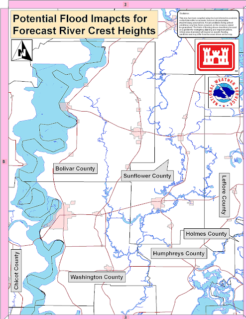
This image was produced over the weekend, when flood stages were predicted to be lower.  It illustrates the projected maximum area of flooding from Yazoo backwater.  NOTE: This is a projection only, and is being revised, and will likely include more areas.  There is no way to predict flooding on a street-by-street level, as roadways, highways, and other features may block waters in any given area.  Blue areas are forecast flood areas. (More text following picture)

This next image illustrates the full Delta area (more text following picture).

I do NOT wish to sound alarmist.  I cannot ever recall seeing flood projections like this for the heart of the Delta.  I encourage you to begin work today to take whatever steps necessary to protect you valuables, your homes, and you family.  Granted, these floods may not materialize, and may not be terribly deep.  But we certainly could expect to see issues develop regarding infrastructure (transportation - road closures, possible water/sewer issues, etc.) 

Other things you can consider:
  • Drinking water - 1 gallon per person, per day.  One case of 16oz water (24 bottles) is enough for 3 people per day.
  • Non-perishable, high-energy foods (anybody in the family have special diets?)
  • Cash-on-hand, should power be lost.
  • Battery-powered lights & radios
  • Well-documented medical information (medical history, current prescriptions, etc).
  • Adequate supply of prescription medications
  • Pets?  Relocate them to family outside of the area?
There are a host of online resources for more information on family disaster planning.  You can start with http://www.ready.gov/america/beinformed/floods.html

The graphic below illustrates the current forecast for Mississippi River stages.  No further text occurs beyond the image.  I'll provide you another update as more information becomes available.


***DO NOT USE THIS WEBSITE AS YOUR SOLE SOURCE OF WEATHER INFORMATION, ESPECIALLY WATCHES AND WARNINGS. THIS WEBSITE DELIVERS FOCUSED INFORMATION FOR A SPECIFIC GEOGRAPHIC AREA AND IS NOT INTENDED TO PROVIDE TIMELY WEATHER WARNING INFORMATION***

Sunday, May 1, 2011

Weather we can live with - week of 5/1/2011

The hazardous weather outlook issued this morning states that "today through Saturday...the probability for widespread hazardous weather is low".

A perfect forecast, in my opinion.  We'll keep you updated if anything changes.  Have a great week everyone!

***DO NOT USE THIS WEBSITE AS YOUR SOLE SOURCE OF WEATHER INFORMATION, ESPECIALLY WATCHES AND WARNINGS. THIS WEBSITE DELIVERS FOCUSED INFORMATION FOR A SPECIFIC GEOGRAPHIC AREA AND IS NOT INTENDED TO PROVIDE TIMELY WEATHER WARNING INFORMATION***