Watches, Warnings & Advisories for Sunflower Co.

Monday, November 28, 2011

Winter Weather?

There's a slim chance that the Delta area could see snow mixed with rain overnight, but no accumulation is expected due to warmer ground temperatures.  Light amounts of accumulation on elevated surfaces and grassy areas could be seen north of a line from Carrollton to Macon, MS.

For the remainder of the week, expect daytime temperatures around 50 for Tuesday and Wednesday.  Wednesday night into Thursday morning will be the coldest we've seen this fall, with lows around 22 to 27 degrees expected.

Our next best chance of rain will be Sunday or Monday of the coming week.

HAZARDOUS WEATHER OUTLOOK
NATIONAL WEATHER SERVICE JACKSON MS
140 PM CST MON NOV 28 2011

THIS HAZARDOUS WEATHER OUTLOOK IS FOR CENTRAL MISSISSIPPI...
NORTHEAST LOUISIANA...AND EXTREME SOUTHEAST ARKANSAS.

.DAY ONE...TONIGHT AND TUESDAY

LIGHT RAIN TONIGHT MAY MIX WITH AND EVEN CHANGE OVER TO LIGHT SNOW
ACROSS LOCATIONS MAINLY NORTH OF A ROLLING FORK TO CARTHAGE TO DE
KALB MISSISSIPPI LINE...ESPECIALLY AFTER MIDNIGHT. THERE COULD BE A
LIGHT DUSTING OF SNOW ON ELEVATED SURFACES AND IN GRASSY AREAS EARLY
TUESDAY. AS A WORSE CASE...LOCATIONS ALONG AND NORTH OF A GRENADA TO
KOSCIUSKO TO MACON LINE MAY RECEIVE UP TO ONE INCH. HOWEVER...IF THAT
OCCURS...NO IMPACT ON ROADWAYS IS EXPECTED DUE TO THE WARM GROUND
CONDITIONS.

.DAYS TWO THROUGH SEVEN...TUESDAY NIGHT THROUGH SUNDAY

THE PROBABILITY FOR WIDESPREAD HAZARDOUS WEATHER IS LOW.

.SPOTTER CALL TO ACTION STATEMENT...
THE ACTIVATION OF STORM SPOTTERS...HAM RADIO OPERATORS...AND
EMERGENCY MANAGEMENT PERSONNEL IN SUPPORT OF SEVERE WEATHER
OPERATIONS IS NOT EXPECTED THROUGH NEXT SUNDAY.
 

***DO NOT USE THIS WEBSITE AS YOUR SOLE SOURCE OF WEATHER INFORMATION, ESPECIALLY WATCHES AND WARNINGS. THIS WEBSITE DELIVERS FOCUSED INFORMATION FOR A SPECIFIC GEOGRAPHIC AREA AND IS NOT INTENDED TO PROVIDE TIMELY WEATHER WARNING INFORMATION***

Saturday, November 26, 2011

Catching Up...

I've spent the better part of the day cleaning up my radio log book, and WOW...discovered I'm way behind on sending out contact confirmations.  QSL cards represent a written confirmation of contact between two amateur radio stations.  The traditional card has been in use for just shy of one hundred years.  With the advent and prevalence of the internet, and computerized logging systems, a lot of QSL'ing is now done electronically through various online systems.  At my station, I use two online systems, and get a fair amount of feedback through them.  It's quick, easy, and free.

However, there's something missing from a simple online confirmation.  Getting a printed card in the mail from other amateur radio operators in far-flung locations is far more fulfilling.  Instead of an electronic notification, the QSL card includes that personal contact - handwriting, pictures, tidbits of interesting information - from someone in another land.

I've relied exclusively on electronic confirmation for too long.  It's time to put my hand back to my own cards, and send them out to the world.  Cards to Portugal, the Canary Islands, French Polynesia, France, Panama, Italy, Japan, Northern Ireland, Finland, Aruba, Brazil, Ukraine, New Zealand and the Dominican Republic will be sent, along with cards to closer to home in Mississippi, South Carolina, and West Virginia.

UPDATED Hazardous WX Outlook for Nov 26, 2011

UPDATED at 2:45pm

 
HAZARDOUS WEATHER OUTLOOK
NATIONAL WEATHER SERVICE JACKSON MS
205 PM CST SAT NOV 26 2011

THIS HAZARDOUS WEATHER OUTLOOK IS FOR SOUTHEAST ARKANSAS...NORTHEAST
LOUISIANA...AND MUCH OF CENTRAL AND SOUTHERN MISSISSIPPI.

.DAY ONE...TODAY AND TONIGHT
A BAND OF STRONG TO ISOLATED SEVERE THUNDERSTORMS WILL MOVE ACROSS
THE REGION LATE THIS AFTERNOON AND TONIGHT AHEAD OF A SLOW MOVING
COLD FRONT. WIND GUSTS TO 60 MPH WILL BE THE MAIN SEVERE WEATHER
THREAT...BUT A TORNADO COULD ALSO BE POSSIBLE. THE MAIN BAND OF
THUNDERSTORMS IS EXPECTED TO AFFECT AREAS ALONG AND WEST OF THE
MISSISSIPPI RIVER BETWEEN 3 AND 7 PM...BE ALONG THE INTERSTATE 55
CORRIDOR BETWEEN 8 AND 11 PM...AND BE OVER EASTERN MISSISSIPPI
BETWEEN 11 PM AND 4 AM.

.DAYS TWO THROUGH SEVEN...SUNDAY THROUGH FRIDAY
THE PROBABILITY OF WIDESPREAD HAZARDOUS WEATHER IS LOW.

.SPOTTER CALL TO ACTION STATEMENT...
THE ACTIVATION OF STORM SPOTTERS...HAM RADIO OPERATORS...AND
EMERGENCY MANAGEMENT PERSONNEL IN SUPPORT OF SEVERE WEATHER
OPERATIONS...COULD BE NEEDED THIS AFTERNOON AND TONIGHT.


***DO NOT USE THIS WEBSITE AS YOUR SOLE SOURCE OF WEATHER INFORMATION, ESPECIALLY WATCHES AND WARNINGS. THIS WEBSITE DELIVERS FOCUSED INFORMATION FOR A SPECIFIC GEOGRAPHIC AREA AND IS NOT INTENDED TO PROVIDE TIMELY WEATHER WARNING INFORMATION***

Hazardous Weather Outlook, Saturday, Nov 26, 2011

HAZARDOUS WEATHER OUTLOOK
NATIONAL WEATHER SERVICE JACKSON MS
542 AM CST SAT NOV 26 2011
 
**THIS HAZARDOUS WEATHER OUTLOOK IS FOR PORTIONS OF CENTRAL
MISSISSIPPI...NORTHEAST LOUISIANA...AND EXTREME SOUTHEAST ARKANSAS
(Highway 82 Corridor).

STRONG THUNDERSTORMS CAPABLE OF PRODUCING WIND GUSTS OF 40
TO 50 MPH WILL BE POSSIBLE LATE THIS AFTERNOON AND EVENING. THESE
STORMS ARE EXPECTED TO DEVELOP ALONG AND AHEAD OF A COLD FRONT THAT
WILL BE MOVING ACROSS THE REGION. THE COLD FRONT IS EXPECTED TO BE
JUST EAST OF THE MISSISSIPPI RIVER BY MIDNIGHT AND SOUTHEAST OF THE
OUTLOOK AREA WELL BEFORE SUNRISE.

**THIS HAZARDOUS WEATHER OUTLOOK IS FOR PORTIONS OF CENTRAL
MISSISSIPPI AND EAST CENTRAL LOUISIANA (Interstate 20 Corridor and south).

.DAY ONE...TODAY AND TONIGHT

STRONG TO SEVERE STORMS WILL BE POSSIBLE FROM LATE THIS AFTERNOON
THROUGH TONIGHT ALONG AND JUST AHEAD OF A STRONG COLD FRONT THAT WILL
BE MOVING ACROSS THE REGION. WIND GUSTS TO 60 MPH WILL BE THE MAIN
THREAT BUT A TORNADO OR TWO WILL ALSO BE POSSIBLE. THE COLD FRONT IS
EXPECTED TO BE NEAR THE MISSISSIPPI RIVER BY MIDNIGHT AND BE OVER
SOUTHEAST MISSISSIPPI BY SUNRISE SUNDAY MORNING.

.DAYS TWO THROUGH SEVEN...SUNDAY THROUGH FRIDAY

THE PROBABILITY FOR WIDESPREAD HAZARDOUS WEATHER IS LOW.

.SPOTTER CALL TO ACTION STATEMENT...
THE ACTIVATION OF STORM SPOTTERS...HAM RADIO OPERATORS...AND
EMERGENCY MANAGEMENT PERSONNEL IN SUPPORT OF SEVERE WEATHER
OPERATIONS...MAY BE NEEDED LATER THIS AFTERNOON AND TONIGHT.


***DO NOT USE THIS WEBSITE AS YOUR SOLE SOURCE OF WEATHER INFORMATION, ESPECIALLY WATCHES AND WARNINGS. THIS WEBSITE DELIVERS FOCUSED INFORMATION FOR A SPECIFIC GEOGRAPHIC AREA AND IS NOT INTENDED TO PROVIDE TIMELY WEATHER WARNING INFORMATION***

Thursday, November 24, 2011

60 Meter Band Changes Proposed

The FCC recently published changes to the 60-Meter band.  The entire Report & Order can be found here.  Or click here for a PDF version.  The American Radio Relay League's article on the changes can be found here.  As of Thursday morning, 11/24/2011, the Report & Order had not been published in the Federal Register.  The rule changes will not take effect until 30 days after publication.

Various articles on this change can be found on www.eham.com, www.60meters.net, here, here, here, here, and here.

Under the new plan, the 60 meter band 5MHz Channel List will be:

5330.5 kHz USB (center of channel 5332.0)
5346.5 kHz USB (center of channel 5348.0)
5357.0 kHz USB (center of channel 5358.5)
5371.5 kHz USB (center of channel 5373.0)
5403.5 kHz USB (center of channel 5405.0)

Monday, November 21, 2011

Hazardous Weather Outlook for Tuesday Nov 22, 2011

As promised, here is the most current thinking on the potential for severe weather on Tuesday, 11/22/2011

As a cold front approaches western Mississippi early tomorrow, a line of thunderstorms will develop along the front.  Additionally, there is the potential for discrete thunderstorms to develop independently ahead of the frontal boundary.  Hail, high winds and locally heavy rainfall are all possible with these storms.  Tornado development cannot be ruled out as these storms pass.

Storm development is expected to begin in the western portions of Mississippi around daybreak, from 6am through noon.  Areas along the Natchez Trace corridor should see storms move through between 11am and 5pm, and finally areas of southeastern Mississippi will see the front pass through between 3pm and midnight.  The greatest potential for severe weather development is expected to be south of a line from Grenada, Mississippi, to Morehouse Parish, Louisiana.  While this indicates less risk for the western portion of the Mississippi Delta (Bolivar, Sunflower, Washington counties), readers in those area should remain alert to developing weather conditions. 

Illustrative graphics can be found below the hazardous weather outlook.

HAZARDOUS WEATHER OUTLOOK
NATIONAL WEATHER SERVICE JACKSON MS
311 PM CST MON NOV 21 2011

THIS HAZARDOUS WEATHER OUTLOOK IS FOR CENTRAL MISSISSIPPI...
NORTHEAST LOUISIANA...AND EXTREME SOUTHEAST ARKANSAS.

.DAY ONE...TONIGHT THROUGH TUESDAY

SEVERE THUNDERSTORMS WILL BE POSSIBLE TUESDAY INTO TUESDAY EVENING.
THE PRIMARY HAZARD WITH THESE STORMS WILL BE DAMAGING WINDS...BUT
TORNADOES AND LARGE HAIL WILL ALSO BE POSSIBLE. A SQUALL LINE IS
EXPECTED TO DEVELOP ALONG AND JUST AHEAD OF A COLD FRONT EARLY
TUESDAY AND PROGRESS EASTWARD. THE LINE IS EXPECTED TO MOVE INTO
THE WESTERN PORTIONS OF THE AREA BY MID MORNING...THE CENTRAL
PORTIONS OF THE AREA DURING THE AFTERNOON...AND EXIT THE SOUTHEAST
TUESDAY EVENING. ALTHOUGH THE SEVERE STORMS WILL BE POSSIBLE OVER THE
WHOLE OUTLOOK AREA...THE AREA ALONG AND EAST OF A LINE FROM WINNSBORO
LOUISIANA TO GRENADA MISSISSIPPI APPEARS TO HAVE THE GREATEST CHANCE
OF EXPERIENCING SEVERE STORMS TUESDAY.

.DAYS TWO THROUGH SEVEN...TUESDAY NIGHT THROUGH SUNDAY

THE PROBABILITY FOR WIDESPREAD HAZARDOUS WEATHER IS LOW.

.SPOTTER CALL TO ACTION STATEMENT...
THE ACTIVATION OF STORM SPOTTERS...HAM RADIO OPERATORS...AND
EMERGENCY MANAGEMENT PERSONNEL IN SUPPORT OF SEVERE WEATHER
OPERATIONS...WILL LIKELY BE NEEDED TUESDAY INTO TUESDAY EVENING.


***DO NOT USE THIS WEBSITE AS YOUR SOLE SOURCE OF WEATHER INFORMATION, ESPECIALLY WATCHES AND WARNINGS. THIS WEBSITE DELIVERS FOCUSED INFORMATION FOR A SPECIFIC GEOGRAPHIC AREA AND IS NOT INTENDED TO PROVIDE TIMELY WEATHER WARNING INFORMATION***

Stand by for updates for Tuesday's weather

As of this morning, there's no real new information concerning the possibility of severe weather for Tuesday, Nov 22.  We'll be on a conference call with the weather service this afternoon, and will post more information following that call.

Sunday, November 20, 2011

Severe weather possible Tuesday, 11/22/2011

It looks like we'll have another opportunity for severe weather this week, Tuesday and Tuesday evening.  A cold front is expected to move through the region on Tuesday.  A line of severe thunderstorms are expected to develop ahead of this front as it moves into the Delta around mid-day.  The line should pass through the south-east portion of Mississippi around midnight Tuesday night.  Forecasters expect the air mass ahead of the front to be unstable enough to produce severe isolated storms ahead of the squall line.  These isolated thunderstorms and the later squall line could produce hail, damaging winds, and possibly tornadoes.  With a moisture-rich air mass in place, locally heavy rains are also possible.

I'll have more information around mid-afternoon on Monday, and will keep this site updated.  As always, precise predictions this far in advance are almost impossible, but computer models have been in agreement since Friday on this potential for Tuesday.  Below you'll find today's Hazardous Weather Outlook as well as some graphics from the National Weather Service office in Jackson, as well as the Storm Prediction Center in Oklahoma.

Remember, November is our "second season" for severe weather and tornadoes in Mississippi.  Please keep abreast of changing weather conditions by monitoring local media outlets and NOAA Weather Radio.

HAZARDOUS WEATHER OUTLOOK
NATIONAL WEATHER SERVICE JACKSON MS
209 PM CST SUN NOV 20 2011

THIS HAZARDOUS WEATHER OUTLOOK IS FOR PORTIONS OF CENTRAL MISSISSIPPI...NORTHEAST
LOUISIANA AND EXTREME SOUTHEAST ARKANSAS.

.DAY ONE...TONIGHT AND MONDAY

THE PROBABILITY FOR WIDESPREAD HAZARDOUS WEATHER IS LOW.

.DAYS TWO THROUGH SEVEN...MONDAY NIGHT THROUGH SATURDAY

SEVERE THUNDERSTORMS WILL BE POSSIBLE TUESDAY INTO TUESDAY EVENING. THESE
STORMS WILL HAVE THE POTENTIAL FOR DAMAGING WINDS...HAIL AND
TORNADOES. GULF MOISTURE WILL CONTINUE TO PUSH INTO THE AREA TO
PRODUCE AN UNSTABLE AIR MASS THAT WILL BE IN PLACE WHEN A STRONG COLD
FRONT MOVES ACROSS THE REGION EARLY THIS WEEK. LOCALLY HEAVY RAINFALL
WILL ALSO BE POSSIBLE WITH THE STORMS. PLEASE CONTINUE TO MONITOR
THE LATEST FORECASTS AND OUTLOOKS FOR UPDATES ON THIS DEVELOPING
WEATHER EPISODE.

.SPOTTER CALL TO ACTION STATEMENT...
THE ACTIVATION OF STORM SPOTTERS...HAM RADIO OPERATORS...AND
EMERGENCY MANAGEMENT PERSONNEL IN SUPPORT OF SEVERE WEATHER
OPERATIONS...WILL BE NEEDED FOR TUESDAY AND TUESDAY NIGHT. 

Below graphic is Day-3 (Tuesday) Probabilistic Outlook.  This depicts the probability of severe weather within 25 miles of any given point.
 

***DO NOT USE THIS WEBSITE AS YOUR SOLE SOURCE OF WEATHER INFORMATION, ESPECIALLY WATCHES AND WARNINGS. THIS WEBSITE DELIVERS FOCUSED INFORMATION FOR A SPECIFIC GEOGRAPHIC AREA AND IS NOT INTENDED TO PROVIDE TIMELY WEATHER WARNING INFORMATION***

Thursday, November 17, 2011

Severe Weather Survey

The National Weather Service offices in Jackson and Memphis have collaborated with Mississippi State University to develop a survey on the reception of, and response to severe weather warnings in Mississippi and surrounding states.  The NWS offices plan to use the information gathered in this survey to improve their warnings, services, and severe weather educational efforts. 

Clicking here will carry you to an online version of the survey.  Your responses will not be associated with your name, so anonymity is assured.

NWS Jackson excels in their relationship with Mississippi's emergency management community.  Their forecasters work very closely with your local emergency planners to provide you the most timely and reliable information possible.  Please take a few moments to complete this survey and help them continue to improve their services.  Feel free to share the survey link to friends and relatives, too.  You may see this survey link posted in other social media such as Facebook and Twitter.  You only need to participate in the survey once. 

Tuesday, November 15, 2011

Updated Hazardous Weather Outlook for tonight, 11/15/2011

HAZARDOUS WEATHER OUTLOOK
NATIONAL WEATHER SERVICE JACKSON MS
246 PM CST TUE NOV 15 2011

THIS HAZARDOUS WEATHER OUTLOOK IS FOR EXTREME SOUTHEAST
ARKANSAS...NORTHEAST LOUISIANA AND PORTIONS OF CENTRAL MISSISSIPPI
WEST OF THE INTERSTATE 55 CORRIDOR.

.DAY ONE...TONIGHT AND WEDNESDAY

STRONG TO SEVERE STORMS WILL BE POSSIBLE THIS EVENING INTO THE EARLY
OVERNIGHT HOURS AS AN UPPER DISTURBANCE MOVES ACROSS THE REGION.
ENOUGH INSTABILITY AND WIND SHEAR WILL BE PRESENT FOR WINDS UP TO 60
MPH AND A WEAK TORNADO CANNOT BE RULED OUT. THE MAIN TIMEFRAME FOR
THIS ACTIVITY WILL BE FROM AROUND 8 PM TO 2 AM.

.DAYS TWO THROUGH SEVEN...WEDNESDAY NIGHT THROUGH MONDAY

THE PROBABILITY FOR WIDESPREAD HAZARDOUS WEATHER WILL BE LOW.

.SPOTTER CALL TO ACTION STATEMENT...
THE ACTIVATION OF STORM SPOTTERS...HAM RADIO OPERATORS...AND
EMERGENCY MANAGEMENT PERSONNEL IN SUPPORT OF SEVERE WEATHER
OPERATIONS...MAY BE NEEDED THIS EVENING INTO TONIGHT BUT OTHERWISE
IS NOT EXPECTED THROUGH NEXT MONDAY.

Storm Prediction Center Wind outlook for tonight & tomorrow

Storm Prediction Center Tornado outlook for tonight & tomorrow

***DO NOT USE THIS WEBSITE AS YOUR SOLE SOURCE OF WEATHER INFORMATION, ESPECIALLY WATCHES AND WARNINGS. THIS WEBSITE DELIVERS FOCUSED INFORMATION FOR A SPECIFIC GEOGRAPHIC AREA AND IS NOT INTENDED TO PROVIDE TIMELY WEATHER WARNING INFORMATION***

Hazardous Weather Outlook 11/15/2011, 10:30am

It appears the timing for today's storms may have shifted to later afternoon and overnight.  Some areas of South Mississippi are starting to see rain showers this morning.  Eastern areas of the state should start experiencing rain later in the afternoon.  Western areas could see the development of storms through midnight overnight, and possibly into Wednesday morning.


HAZARDOUS WEATHER OUTLOOK
NATIONAL WEATHER SERVICE JACKSON MS
513 AM CST TUE NOV 15 2011

THIS HAZARDOUS WEATHER OUTLOOK IS FOR EXTREME SOUTHEAST
ARKANSAS...NORTHEAST LOUISIANA AND PORTIONS OF CENTRAL MISSISSIPPI.

.DAY ONE...TODAY AND TONIGHT

STRONG TO SEVERE THUNDERSTORMS WILL BE POSSIBLE TONIGHT THROUGH MID
MORNING WEDNESDAY AS A FRONTAL SYSTEM AND ATMOSPHERIC DISTURBANCE
AFFECT THE REGION. THE MAIN RISK WITH ANY SEVERE STORMS WILL BE WIND
GUSTS TO 60 MPH...BUT A TORNADO OR TWO CANNOT BE RULED OUT
CONSIDERING THE EXPECTED PRESENCE OF STRONG ATMOSPHERIC WIND SHEAR.

.DAYS TWO THROUGH SEVEN...WEDNESDAY THROUGH MONDAY

THE RISK OF ANY STRONG TO SEVERE THUNDERSTORMS SHOULD BE DIMINISHING
QUICKLY BY MIDDAY WEDNESDAY.

.SPOTTER CALL TO ACTION STATEMENT...
THE ACTIVATION OF STORM SPOTTERS...HAM RADIO OPERATORS...AND
EMERGENCY MANAGEMENT PERSONNEL IN SUPPORT OF SEVERE WEATHER
OPERATIONS...MAY BE NEEDED TONIGHT THROUGH WEDNESDAY MORNING...BUT IS
OTHERWISE NOT ANTICIPATED THROUGH NEXT MONDAY.
 
 
Storm Prediction Center's outlook for severe weather today

Storm Prediction Center Tornado Outlook for today

Storm Prediction Center Wind Outlook for today

***DO NOT USE THIS WEBSITE AS YOUR SOLE SOURCE OF WEATHER INFORMATION, ESPECIALLY WATCHES AND WARNINGS. THIS WEBSITE DELIVERS FOCUSED INFORMATION FOR A SPECIFIC GEOGRAPHIC AREA AND IS NOT INTENDED TO PROVIDE TIMELY WEATHER WARNING INFORMATION***

Monday, November 14, 2011

Hazardous Weather Outlook, Tuesday 11/15/2011

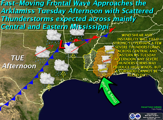
Tuesday afternoon and evening could see the development of strong to severe thunderstorms over a good portion of Mississippi.  Timing and severity are difficult to predict right now, as several variables are in play, including daytime heating & instability development, wind shear, and the amount of moisture available.  Right now, it looks like areas along and east of Interstate 55 will see the first development of rains Tuesday afternoon, then storms in western areas of the state will follow later in the day.  Rainfall amounts, however, should remain relatively low in any given location.

HAZARDOUS WEATHER OUTLOOK
NATIONAL WEATHER SERVICE JACKSON MS
230 PM CST MON NOV 14 2011

THIS HAZARDOUS WEATHER OUTLOOK IS FOR CENTRAL MISSISSIPPI...
NORTHEAST LOUISIANA...AND EXTREME SOUTHEAST ARKANSAS.

.DAY ONE...TONIGHT AND TUESDAY

THE PROBABILITY FOR WIDESPREAD HAZARDOUS WEATHER IS LOW.

.DAYS TWO THROUGH SEVEN...TUESDAY NIGHT THROUGH SUNDAY

STRONG TO SEVERE THUNDERSTORMS WILL DEVELOP TUESDAY NIGHT. THE
PRIMARY HAZARD WITH THESE STORMS WILL BE DAMAGING WIND GUSTS TO 60
MPH BUT WEAK TORNADOES CAN NOT BE RULED OUT.

THE FEED OF GULF MOISTURE INTO THE REGION WILL INCREASE AHEAD OF A
LOW PRESSURE SYSTEM THAT WILL MOVE INTO THE AREA TUESDAY EVENING.
THE AIR MASS WILL REMAIN MARGINALLY UNSTABLE BUT STRONG WIND SHEAR
THAT WILL DEVELOP AHEAD OF THE FRONT WILL BE SUFFICIENT TO SUPPORT
THE POTENTIAL FOR STRONG TO SEVERE STORMS.

.SPOTTER CALL TO ACTION STATEMENT...
THE ACTIVATION OF STORM SPOTTERS...HAM RADIO OPERATORS...AND
EMERGENCY MANAGEMENT PERSONNEL IN SUPPORT OF SEVERE WEATHER
OPERATIONS MAY BE NEEDED TUESDAY NIGHT.


***DO NOT USE THIS WEBSITE AS YOUR SOLE SOURCE OF WEATHER INFORMATION, ESPECIALLY WATCHES AND WARNINGS. THIS WEBSITE DELIVERS FOCUSED INFORMATION FOR A SPECIFIC GEOGRAPHIC AREA AND IS NOT INTENDED TO PROVIDE TIMELY WEATHER WARNING INFORMATION***

Thursday, November 10, 2011

Ham Radio in the 21st Century

Great article over at Electronics Design, Strategy and News on Ham Radio in the 21st Century.  Click and read an interesting piece. 

Freeze Warning Tonight - Nov 10-11, 2011

URGENT - WEATHER MESSAGE
NATIONAL WEATHER SERVICE JACKSON MS
408 AM CST THU NOV 10 2011

...COLD TEMPERATURES EXPECTED LATE TONIGHT INTO FRIDAY MORNING...

...FREEZE WARNING IN EFFECT FROM MIDNIGHT TONIGHT TO 8 AM CST
FRIDAY...

THE NATIONAL WEATHER SERVICE IN JACKSON HAS ISSUED A FREEZE
WARNING...WHICH IS IN EFFECT FROM MIDNIGHT TONIGHT TO 8 AM CST
FRIDAY.

* TIMING: TEMPERATURES ACROSS THE ARKLAMISS REGION WILL DROP DOWN
  INTO THE MID AND UPPER 30S AFTER MIDNIGHT TONIGHT. MANY LOCATIONS
  WILL LATER FALL TO OR JUST BELOW THE FREEZING MARK FOR A FEW HOURS
  BEFORE 8 AM FRIDAY MORNING. CONFIDENCE IN FREEZING AND BELOW
  FREEZING TEMPERATURES IS HIGHEST IN SHELTERED AND RURAL AREAS.

* IMPACTS: SHORT TERM EXPOSURE TO FREEZING TEMPERATURES WILL HAVE THE
  POTENTIAL TO DAMAGE NON HARDY VEGETATION. IN ADDITION...SOME PETS
  UNACCUSTOMED TO THE COLD COULD BE NEGATIVELY IMPACTED IF LEFT
  OUTDOORS THROUGH THE NIGHT.

PRECAUTIONARY/PREPAREDNESS ACTIONS...

A FREEZE WARNING MEANS SUB-FREEZING TEMPERATURES ARE IMMINENT OR
HIGHLY LIKELY. THESE CONDITIONS WILL KILL CROPS AND OTHER
SENSITIVE VEGETATION.


***DO NOT USE THIS WEBSITE AS YOUR SOLE SOURCE OF WEATHER INFORMATION, ESPECIALLY WATCHES AND WARNINGS. THIS WEBSITE DELIVERS FOCUSED INFORMATION FOR A SPECIFIC GEOGRAPHIC AREA AND IS NOT INTENDED TO PROVIDE TIMELY WEATHER WARNING INFORMATION***

Wednesday, November 9, 2011

National Emergency Alert System (EAS) Test - Nov 9, 2011 at 1:00pm CST


Open Letter: Nationwide Emergency Alert System Test

Posted by: Craig Fugate, Administrator, Federal Emergency Management Agency and Julius Genachowski, Chairman, Federal Communications Commission

The first ever nationwide test of the Emergency Alert System will occur on Wednesday, November 9, at 2:00 p.m. EST. As part of our public education campaign, we wrote this open letter to ensure that all Americans are aware of the test and know what to expect.

Please share this information with your friends, family, and coworkers:
Dear Partner,

As part of our nation’s ongoing efforts to strengthen our resilience against all hazards, the Federal Emergency Management Agency (FEMA) and the Federal Communications Commission (FCC), in close coordination with the National Oceanic and Atmospheric Association (NOAA), will conduct the first ever nationwide test of the Emergency Alert System on Wednesday, November 9, at 2:00 p.m. EST. The test will occur simultaneously across the United States and the U.S. territories and will last approximately 30 seconds, after which regular programming will resume. The test will appear on all broadcast radio and television stations, cable television systems, satellite radio and television systems, and wireline video service systems. The test will not involve landline or mobile phones or other infrastructure such as power grids.

The various disasters our country has faced this year underscore the need for effective and well-tested emergency alert and warning systems that could be used in a time of real national emergency, at a moment’s notice. Now, with the test less than a week away, we ask that you join us in efforts to educate your entire community about this important event.

Although the Emergency Alert System and its predecessors have been in existence for more than 50 years and are often tested at the local level, there has never been a nationwide test of these capabilities. The purpose of the test is to allow FEMA and the FCC to assess how well the Emergency Alert System would perform its primary function: alerting the public about a national emergency.

The first step toward building a modernized Emergency Alert System means testing the existing technology. Through preparations for the test, we have already identified areas that need improvement to ensure our entire population has full access to alerts and warnings. This nationwide test will help us identify any additional changes to the system that may be beneficial as we work to complete a modernized and fully accessible system.

A shortcoming of the system that we identified early in the process is that the fifty-year old system was not built to support open or closed captioning, translations, or other tools to supplement the audio portion of the test for broader accessibility. Consequently, many viewers, particularly cable television subscribers, will see the emergency alert on the screen that is accompanied by an audio explanation that "this is only a test," but may not see a corresponding visual message that "this is only a test." Knowing these limitations, FEMA and the FCC have targeted our outreach efforts to help ensure that the public knows what to expect when the test occurs. And, in these past weeks leading up to the test, the broadcast community, cable operators and programmers, and other communications service providers have conscientiously assisted in this effort by alerting their viewers and subscribers about the test—through visual and written communications.

Over the past year, our agencies have also been working extensively with our state, local, tribal, and territorial partners, and other critical stakeholders to help inform all members of the public regarding the nationwide Emergency Alert System test. In particular, we have conducted extensive outreach to the deaf and hard of hearing community to alert them about the test, including the technical limitations with the visual message, particularly with respect to cable television. To ensure that everyone is aware that the nationwide test on November 9 is only a test, we are also requesting your assistance with outreach. We particularly request that you provide information to people who are deaf and hard of hearing, people with cognitive or intellectual disabilities or mental health concerns, senior citizens, and people with limited English proficiency to build awareness and understanding about the test.

Specifically, we ask that you help us educate your communities regarding some important facts about the test:


  • The test will be approximately 30 seconds long and will look and sound very similar to the frequent local tests of the Emergency Alert System;
  • It will be transmitted via television and radio stations within the U.S., including Alaska, Hawaii, the territories of Puerto Rico, the U.S. Virgin Islands, and American Samoa;
  • An audio message will interrupt television and radio programming indicating: “This is only a test,” though text may not indicate this same message on the screen on every television channel;
  • Organizations that serve people with disabilities or people with limited English proficiency should be aware that they may receive requests for information or assistance from broadcasters or other communications service providers and emergency managers in the days leading up to, during, and after the test; and
  • When the test is over, regular programming will resume. In the coming days, our agencies will be releasing additional information to help inform the public about this test. Resources, including videos in accessible formats, can be found at www.fema.gov/eastest.

As with all of our work, we know that the support of our state, local, tribal and territorial partners, along with the private sector, our faith-based and disability communities, and other key stakeholders, will be vital to effectively raising the public’s awareness of the test and minimizing undue public concern. We greatly appreciate your continued partnership as we prepare for this unique event and important public service. Your efforts to help us get the message out will be invaluable.

Sincerely,

W. Craig Fugate
ADMINISTRATOR
Federal Emergency Management Agency

Julius Genachowski
CHAIRMAN
Federal Communications Commission


***DO NOT USE THIS WEBSITE AS YOUR SOLE SOURCE OF WEATHER INFORMATION, ESPECIALLY WATCHES AND WARNINGS. THIS WEBSITE DELIVERS FOCUSED INFORMATION FOR A SPECIFIC GEOGRAPHIC AREA AND IS NOT INTENDED TO PROVIDE TIMELY WEATHER WARNING INFORMATION***

Tuesday, November 8, 2011

**UPDATED** Hazardous Weather Outlook - Nov 8, 2011

**UPDATED at 3:30pm**

HAZARDOUS WEATHER OUTLOOK
NATIONAL WEATHER SERVICE JACKSON MS
215 PM CST TUE NOV 8 2011

THIS HAZARDOUS WEATHER OUTLOOK IS FOR PORTIONS OF CENTRAL
MISSISSIPPI...NORTHEAST LOUISIANA AND EXTREME SOUTHEAST ARKANSAS.

.DAY ONE...TONIGHT AND WEDNESDAY

A FEW STRONG TO SEVERE THUNDERSTORMS WILL BE POSSIBLE BETWEEN 10 PM
AND 1 AM AS A WEAKENING SQUALL LINE SWEEPS EAST ACROSS THE REGION AHEAD
OF A COLD FRONT. THE PRIMARY RISK WITH THIS ACTIVITY WILL BE
DAMAGING WIND GUSTS UP TO 60 MPH.

.DAYS TWO THROUGH SEVEN...WEDNESDAY NIGHT THROUGH MONDAY

A LIGHT FREEZE WILL BE POSSIBLE EARLY FRIDAY MORNING AS HIGH PRESSURE
SETTLES OVER THE REGION IN THE PRESENCE OF CLEAR SKIES AND LIGHT
WINDS. PRECAUTIONS SHOULD BE TAKEN TO PROTECT OUTDOOR ANIMALS AND
SENSITIVE VEGETATION.

.SPOTTER CALL TO ACTION STATEMENT...
THE ACTIVATION OF STORM SPOTTERS...HAM RADIO OPERATORS...AND
EMERGENCY MANAGEMENT PERSONNEL IN SUPPORT OF SEVERE WEATHER
OPERATIONS...MAY BE NEEDED TONIGHT.


***DO NOT USE THIS WEBSITE AS YOUR SOLE SOURCE OF WEATHER INFORMATION, ESPECIALLY WATCHES AND WARNINGS. THIS WEBSITE DELIVERS FOCUSED INFORMATION FOR A SPECIFIC GEOGRAPHIC AREA AND IS NOT INTENDED TO PROVIDE TIMELY WEATHER WARNING INFORMATION***

Hazardous Weather Outlook - Nov 8, 2011

HAZARDOUS WEATHER OUTLOOK
NATIONAL WEATHER SERVICE JACKSON MS
449 AM CST TUE NOV 8 2011

THIS HAZARDOUS WEATHER OUTLOOK IS FOR PORTIONS OF CENTRAL
MISSISSIPPI...NORTHEAST LOUISIANA...AND EXTREME SOUTHEAST ARKANSAS.

.DAY ONE...TODAY AND TONIGHT

STRONG TO SEVERE THUNDERSTORMS WILL BE POSSIBLE THIS EVENING INTO EARLY
WEDNESDAY MORNING AHEAD OF A COLD FRONT THAT WILL BE CROSSING THE
REGION. THE PRIMARY RISK WILL BE WIND GUSTS UP TO 60 MPH FOR
LOCATIONS GENERALLY NORTHWEST OF A ACME LOUISIANA...TO VICKSBURG...TO
GRENADA MISSISSIPPI LINE WITH A WEAKENING SQUALL LINE THAT LIKELY
WILL SWEEP EAST WITH THE FRONT. OTHERWISE...THE PROBABILITY FOR
WIDESPREAD HAZARDOUS WEATHER WILL BE LOW.

.DAYS TWO THROUGH SEVEN...WEDNESDAY THROUGH MONDAY

A LIGHT FREEZE WILL BE POSSIBLE LATE THURSDAY NIGHT AS HIGH PRESSURE
SETTLES OVER THE REGION IN THE PRESENCE OF CLEAR SKIES AND LIGHT
WINDS.

.SPOTTER CALL TO ACTION STATEMENT...
THE ACTIVATION OF STORM SPOTTERS...HAM RADIO OPERATORS...AND
EMERGENCY MANAGEMENT PERSONNEL IN SUPPORT OF SEVERE WEATHER
OPERATIONS...MAY BE NEEDED TONIGHT.


***DO NOT USE THIS WEBSITE AS YOUR SOLE SOURCE OF WEATHER INFORMATION, ESPECIALLY WATCHES AND WARNINGS. THIS WEBSITE DELIVERS FOCUSED INFORMATION FOR A SPECIFIC GEOGRAPHIC AREA AND IS NOT INTENDED TO PROVIDE TIMELY WEATHER WARNING INFORMATION***

Sunday, November 6, 2011

Hazardous Weather for Tuesday, Nov 8

HAZARDOUS WEATHER OUTLOOK
NATIONAL WEATHER SERVICE JACKSON MS
138 PM CST SUN NOV 6 2011

THIS HAZARDOUS WEATHER OUTLOOK IS FOR CENTRAL MISSISSIPPI...
NORTHEAST LOUISIANA...AND EXTREME SOUTHEAST ARKANSAS.

.DAY ONE...TONIGHT AND MONDAY

THE PROBABILITY FOR WIDESPREAD HAZARDOUS WEATHER IS LOW.

.DAYS TWO THROUGH SEVEN...MONDAY NIGHT THROUGH SATURDAY

STRONG THUNDERSTORMS WILL BE POSSIBLE TUESDAY EVENING INTO EARLY
WEDNESDAY MORNING AHEAD OF A COLD FRONT THAT WILL BE CROSSING THE REGION.
THE PRIMARY RISK WILL BE WIND GUSTS UP TO 50 MPH FOR LOCATIONS
GENERALLY NORTHWEST OF A ACME LOUISIANA...TO VICKSBURG...TO GRENADA
MISSISSIPPI LINE WITH A WEAKENING SQUALL LINE THAT LIKELY WILL SWEEP
EAST WITH THE FRONT. OTHERWISE...THE PROBABILITY FOR WIDESPREAD
HAZARDOUS WEATHER WILL BE LOW.

.SPOTTER CALL TO ACTION STATEMENT...
THE ACTIVATION OF STORM SPOTTERS...HAM RADIO OPERATORS...AND
EMERGENCY MANAGEMENT PERSONNEL IN SUPPORT OF SEVERE WEATHER
OPERATIONS IS NOT EXPECTED THROUGH NEXT SATURDAY.


***DO NOT USE THIS WEBSITE AS YOUR SOLE SOURCE OF WEATHER INFORMATION, ESPECIALLY WATCHES AND WARNINGS. THIS WEBSITE DELIVERS FOCUSED INFORMATION FOR A SPECIFIC GEOGRAPHIC AREA AND IS NOT INTENDED TO PROVIDE TIMELY WEATHER WARNING INFORMATION***