Watches, Warnings & Advisories for Sunflower Co.

Saturday, March 31, 2012

Storms Possible 3/31/12

HAZARDOUS WEATHER OUTLOOK
NATIONAL WEATHER SERVICE JACKSON MS
543 AM CDT SAT MAR 31 2012

THIS HAZARDOUS WEATHER OUTLOOK IS FOR NORTH...NORTHEAST AND EAST
CENTRAL MISSISSIPPI.

.DAY ONE...TODAY AND TONIGHT

PATCHY FOG THAT WAS LOCALLY DENSE IN PLACES WILL BURN OFF BY MID
MORNING. THEN...A FAST-MOVING UPPER LEVEL DISTURBANCE WILL CROSS
A HIGHLY UNSTABLE AIR MASS THIS AFTERNOON TO BRING A RISK FOR SEVERE
THUNDERSTORMS AND LOCALLY HEAVY RAINFALL TO THE OUTLOOK AREA FROM
ABOUT NOON UNTIL 9 PM TONIGHT...MAINLY ALONG AND NORTH OF A MERIDIAN
TO GREENVILLE MISSISSIPPI LINE. THESE STORMS WILL HAVE THE POTENTIAL
FOR HAIL UP TO HALF DOLLAR SIZE AND DAMAGING WIND GUSTS OF 65 MPH.
THE STORMS SHOULD DISSIPATE AFTER SUNSET.

.DAYS TWO THROUGH SEVEN...SUNDAY THROUGH FRIDAY

A STRONG SPRING STORM SYSTEM IS CURRENTLY EXPECTED TO PUSH INTO THE
OUTLOOK AREA SOMETIME DURING THE FIRST HALF OF THE NEW WORK WEEK...
BRINGING WITH IT A MULTIPLE CHANCES FOR SEVERE STORMS. MUCH
UNCERTAINTY REMAINS WITH THE EXACT TIMING AND TRACK OF THIS
SYSTEM...THEREFORE RESIDENTS ACROSS THE OUTLOOK AREA SHOULD CONTINUE
TO MONITOR THE LATEST FORECASTS CONCERNING THIS SEVERE WEATHER
POTENTIAL FOR NEXT WEEK.

.SPOTTER CALL TO ACTION STATEMENT...
THE ACTIVATION OF STORM SPOTTERS...HAM RADIO OPERATORS...AND
EMERGENCY MANAGEMENT PERSONNEL IN SUPPORT OF SEVERE WEATHER
OPERATIONS...MAY BE NEEDED THIS AFTERNOON AND EVENING...AND AGAIN
AT TIMES DURING THE FIRST HALF OF THE NEW WORK WEEK.


***DO NOT USE THIS WEBSITE AS YOUR SOLE SOURCE OF WEATHER INFORMATION, ESPECIALLY WATCHES AND WARNINGS. THIS WEBSITE DELIVERS FOCUSED INFORMATION FOR A SPECIFIC GEOGRAPHIC AREA AND IS NOT INTENDED TO PROVIDE TIMELY WEATHER WARNING INFORMATION***

Thursday, March 29, 2012

Storms possible Monday, 4/2/12

HAZARDOUS WEATHER OUTLOOK
NATIONAL WEATHER SERVICE JACKSON MS
431 AM CDT THU MAR 29 2012

THIS HAZARDOUS WEATHER OUTLOOK IS FOR EXTREME SOUTHEASTERN
ARKANSAS...NORTHEASTERN LOUISIANA AND CENTRAL MISSISSIPPI.

.DAY ONE...TODAY AND TONIGHT

THE PROBABILITY FOR WIDESPREAD HAZARDOUS WEATHER IS LOW.

.DAYS TWO THROUGH SEVEN...FRIDAY THROUGH WEDNESDAY

ISOLATED STRONG THUNDERSTORMS CAPABLE OF PRODUCING TORRENTIAL
DOWNPOURS...SMALL HAIL AND WIND GUSTS TO 50 MPH WILL BE POSSIBLE
FRIDAY AFTERNOON INTO THE EARLY EVENING HOURS...ESPECIALLY ALONG AND
SOUTH OF THE INTERSTATE TWENTY CORRIDOR.

STRONG SOUTHERLY WINDS OF 15 TO 30 MPH SHOULD DEVELOP MONDAY AS
THUNDERSTORMS INCLUDING ALL MODES OF SEVERE WEATHER WILL BE POSSIBLE
STARTING MONDAY AFTERNOON THROUGH MONDAY NIGHT. A POWERFUL SPRING
STORM SYSTEM WILL BE SWEEPING PLENTY OF INSTABILITY AND WIND SHEAR
THROUGH OUR REGION FROM THE SOUTHERN PLAINS BRINGING THE RISK FOR
SEVERE STORMS...INCLUDING TORNADOES. ALL RESIDENTS WILL NEED TO STAY
TUNED TO LATER FORECASTS CONCERNING THIS SEVERE WEATHER POTENTIAL.

.SPOTTER CALL TO ACTION STATEMENT...
THE ACTIVATION OF STORM SPOTTERS...HAM RADIO OPERATORS...AND
EMERGENCY MANAGEMENT PERSONNEL IN SUPPORT OF SEVERE WEATHER
OPERATIONS WILL PROBABLY BE NEEDED MONDAY INTO MONDAY NIGHT.


***DO NOT USE THIS WEBSITE AS YOUR SOLE SOURCE OF WEATHER INFORMATION, ESPECIALLY WATCHES AND WARNINGS. THIS WEBSITE DELIVERS FOCUSED INFORMATION FOR A SPECIFIC GEOGRAPHIC AREA AND IS NOT INTENDED TO PROVIDE TIMELY WEATHER WARNING INFORMATION***

Tuesday, March 20, 2012

Wet Week Ahead

It looks like we're in for a round of slow-moving rain over the next few days.  Generally, 1 to 3 to 5 inches of rain are forecast across Mississippi through Thursday.  Currently, the Highway 82 corridor appears to be in for up to 3 inches of rain, with higher amounts - up to 5 inches - to the south of the Delta.  A Flash Flood Watch is in effect for areas south of a line from Greenville to Laurel.

For Wednesday, there is a chance for strong to severe storms, but those should stay generally to the south of the Delta area.  However, heavy rainfall can be expected.

Here's  a couple of graphics that lay out the current forecast.


***DO NOT USE THIS WEBSITE AS YOUR SOLE SOURCE OF WEATHER INFORMATION, ESPECIALLY WATCHES AND WARNINGS. THIS WEBSITE DELIVERS FOCUSED INFORMATION FOR A SPECIFIC GEOGRAPHIC AREA AND IS NOT INTENDED TO PROVIDE TIMELY WEATHER WARNING INFORMATION***

Sunday, March 11, 2012

Hazardous Weather Outlook - 3/11/12

HAZARDOUS WEATHER OUTLOOK
NATIONAL WEATHER SERVICE JACKSON MS
224 PM CDT SUN MAR 11 2012

THIS HAZARDOUS WEATHER OUTLOOK IS FOR EXTREME SOUTHEASTERN
ARKANSAS...NORTHEASTERN LOUISIANA...AND PORTIONS OF WESTERN
MISSISSIPPI.

.DAY ONE...TONIGHT AND MONDAY

A FEW SEVERE THUNDERSTORMS WILL BE POSSIBLE THIS EVENING FOR AREAS
ALONG AND WEST OF A CLEVELAND...TO LAKE PROVIDENCE...TO ACME
LOUISIANA LINE AS A COLD FRONT PUSHES IN FROM THE WEST. THESE STORMS
WILL BE CAPABLE OF PRODUCING DAMAGING WIND GUSTS AND HAIL TO QUARTER
SIZE. TORNADOES WITH THIS ACTIVITY CANNOT BE RULED OUT...BUT THE
TORNADO RISK IS HIGHEST ACROSS SOUTHEASTERN ARKANSAS AND MOREHOUSE
PARISH IN LOUISIANA.

OTHERWISE...A FEW STRONG THUNDERSTORMS CAPABLE OF WIND GUSTS UP TO 50
MPH AND PENNY TO NICKEL SIZE HAIL ARE POSSIBLE THIS EVENING THROUGH
TONIGHT ALONG AND NORTHWEST OF A NATCHEZ...TO VICKSBURG...TO
GREENWOOD LINE. IN ADDITION...THERE WILL BE THE POTENTIAL FOR
REPEATED HEAVY DOWNPOURS OVER THIS PERIOD AND ISOLATED RAINFALL
TOTALS OF 1 TO 2 INCHES ARE POSSIBLE.

.DAYS TWO THROUGH SEVEN...MONDAY NIGHT THROUGH SATURDAY

THE SAME SLOW MOVING FRONTAL BOUNDARY SHOULD CONTINUE TO PRODUCE
THUNDERSTORM ACTIVITY ACROSS THE REGION MONDAY AFTERNOON. SOME OF
THESE STORMS WILL BE STRONG AND CAPABLE OF PRODUCING GUSTY WINDS TO
50 MPH AND PENNY TO NICKEL SIZE HAIL. A FEW SEVERE STORMS PRODUCING
DAMAGING WIND GUSTS AND HAIL UP TO QUARTER SIZE WILL BE POSSIBLE.

.SPOTTER CALL TO ACTION STATEMENT...
THE ACTIVATION OF STORM SPOTTERS...HAM RADIO OPERATORS...AND
EMERGENCY MANAGEMENT PERSONNEL IN SUPPORT OF SEVERE WEATHER
OPERATIONS...MAY BE NEEDED THIS EVENING AND TOMORROW AFTERNOON.
 

***DO NOT USE THIS WEBSITE AS YOUR SOLE SOURCE OF WEATHER INFORMATION, ESPECIALLY WATCHES AND WARNINGS. THIS WEBSITE DELIVERS FOCUSED INFORMATION FOR A SPECIFIC GEOGRAPHIC AREA AND IS NOT INTENDED TO PROVIDE TIMELY WEATHER WARNING INFORMATION***

Saturday, March 10, 2012

Disaster Preps: Information

Have you seen Doomsday Preppers on the National Geographic Channel?  Unfortunately Thankfully, we don't get the NatGeo channel on our satellite, so I haven't seen it.  But from what I've heard and read around the web, it's...um...interesting.  Something tells me the producers found the most radical people out there and put them on TV.  That's good for ratings I guess, but doing so casts a bad light on the notion of disaster preparedness for your family.  There are plenty of simple, relatively inexpensive steps you can take to soften the blow of a sudden emergency or disaster.

In a previous entry about Community Emergency Response Teams, I mentioned that we would offer simple ideas on a regular basis, to help you with planning for your family's protection.

Family disaster planning can be as small, or as big of a project as you want it to be.  In this series of articles, we'll give you an outline of themes - security, sustenance, supplies, safety, etc., and try not to get "down in the weeds" of details.

This week, I'm going to re-post an article we featured in October of 2011.  Recent major disasters have taught us that personal information is as important as food and water.  Yes, a notebook won't keep you alive, but the information contained within will give you an advantage when calamity visits.  Brief medical records, banking records, vital records, all are important to rebuild your post-disaster life.  The data about your life isn't the first thing you pack up to evacuate.  A week or two later though, you'll wish you had it.

Here's a re-run of that post entry:

Thursday, October 20, 2011

Preparedness: The Big Book

Disaster preparedness and planning can be a complex, lengthy, and sometimes expensive endeavor.  Communities, states, and federal authorities constantly refine their plans for response and recovery.  Mitigation projects like flood control systems and building codes help reduce the potential effects of disasters.  Preparedness requires that we acquire and maintain supplies, equipment, and trained personnel in a state of readiness.  While our governing authorities do what they can, there remains one area of preparedness that no governmental entity can address:  you and your family's own personal state of readiness.  By undertaking a family disaster planning project, you can reduce your household's potential demands on your community's response.  By extension, the more well-prepared families there are, the more prepared the overall community is.

There are dozens of resources online to guide you through various aspects of personal disaster preparedness.  www.ready.gov is a great place to find basic information on disaster kits, food and water supply ideas, and other simple steps you can take.

While food, water, clothing, and shelter are absolutely essential to survival, I want to use this blog entry to remind you that following the immediate threats of an emergency, information is as essential to your recovery as the items previously mentioned.

A highly useful tool that I'm adding to my family's growing emergency plan is The Big Book of Everything, compiled by Erik A. Dewey.  Clicking that link will take you to a page where you can download either an Adobe PDF, or Microsoft Excel version of The Big Book.

The Big Book may seem daunting at first, but by compiling the information in incremental steps over the period of a few weeks, you'll develop a comprehensive document that details emergency information such as family contacts, as well as capturing important financial and other critical data.

What do you do with all this valuable - and sensitive - information?  I wouldn't recommend having a printed copy laying around the house for burglars to find your banking information.  Instead, print out only those essential pages that contain emergency points of contact, and keep it safely stored in a location known by all family members.

An option that we're exploring is storing a non-editable PDF version of The Big Book on key-shaped flash drives.  These won't occupy valuable space in your pocket, but will allow you to keep vital information easily accessible.  Yes, it is sensitive data.  But you can easily encrypt it using a very lightweight program called TrueCrypt, for which the price is right: it's absolutely free.  We'll also store scanned copies of important documents in that encrypted file as well.  If you wish, it may be helpful to have a non-encrypted version of The Big Book on your jump drive.  Just redact any information that could be used should the drive become lost. (Think CIA black pen marks - just black out the sensitive information on Excel then save it as a PDF).

We'll most likely have multiple copies of these flash drives, distributed out to family members both locally and non-local.  Twice a year (or more often if needed) they'll be collected and updated as information changes.

Why go through this exercise?  We have the capacity to digitize a huge portion of our lives, for relatively little cost.  I have several years worth of bank records, payroll records, and other documents stored digitally in multiple locations.  In the unlikely event that a disaster requires our evacuation, consider how much time we would save by not having to identify, find, collect, and store the paper documents.  Digital copies will never replace certified originals. Having volumes of information compressed into something the size of my house key, easily portable and securely encrypted will give my family the chance of a less-stressful recovery should we need it.

The Big Book isn't - and shouldn't be - your family's entire disaster plan.  It is just one part of a multifaceted plan that includes out-of-town/state contacts, pre-determined family evacuation locations (in town, out of town), basic food & water supplies, and emergency action steps for specific hazards like fires and thunderstorms.  The Big Book does, however, give you a one-stop-shop for a host of critical information that you'll wish you had.

What's your plan?

Make a Change....

Want to make two quick, positive changes for you family tonight?  Two simple things that can keep you on time, and possibly save your lives?

Set your clocks ahead one hour tonight before bedtime!


And, change the batteries in your smoke detectors!

Quick, simple, easy...

Hazardous Weather Outlook for 3/11-12/12

HAZARDOUS WEATHER OUTLOOK
NATIONAL WEATHER SERVICE JACKSON MS
349 AM CST SAT MAR 10 2012

THIS HAZARDOUS WEATHER OUTLOOK IS FOR NORTHEAST LOUISIANA...EXTREME
SOUTHEAST ARKANSAS AND PORTIONS OF WESTERN MISSISSIPPI.

.DAY ONE...TODAY AND TONIGHT

THE PROBABILITY FOR WIDESPREAD HAZARDOUS WEATHER IS LOW.

.DAYS TWO THROUGH SEVEN...SUNDAY THROUGH FRIDAY

A FEW STRONG THUNDERSTORMS CAPABLE OF WIND GUSTS UP TO 50 MPH AND
NICKEL TO PENNY SIZED HAIL COULD BE POSSIBLE LATE SUNDAY AFTERNOON
THROUGH SUNDAY NIGHT ALONG AND NORTH OF A NATCHEZ...TO VICKSBURG...TO
GRENADA LINE. IN ADDITION...ESPECIALLY ALONG AND NORTHWEST OF
WINNSBORO TO GREENWOOD LINE...THERE WILL BE THE POTENTIAL FOR
REPEATED HEAVY DOWNPOURS OVER THIS PERIOD AND ISOLATED RAINFALL
TOTALS OF 1 TO 2 INCHES ARE POSSIBLE. FLOODING IS GENERALLY NOT
ANTICIPATED ALTHOUGH A FEW PONDING OF WATER ISSUES MAY ARISE.

THE SAME SLOW MOVING FRONTAL BOUNDARY COULD CONTINUE TO PRODUCE
THUNDERSTORM ACTIVITY ACROSS THE REGION MONDAY AFTERNOON. A FEW OF
THESE STORMS...MAINLY ALONG AND NORTH OF THE HIGHWAY 82
CORRIDOR...COULD BE STRONG AND CAPABLE OF PRODUCING GUSTY WINDS TO 50
MPH AND NICKEL TO PENNY SIZE HAIL.

.SPOTTER CALL TO ACTION STATEMENT...
THE ACTIVATION OF STORM SPOTTERS...HAM RADIO OPERATORS...AND
EMERGENCY MANAGEMENT PERSONNEL IN SUPPORT OF SEVERE WEATHER
OPERATIONS IS NOT EXPECTED THROUGH NEXT FRIDAY.


***DO NOT USE THIS WEBSITE AS YOUR SOLE SOURCE OF WEATHER INFORMATION, ESPECIALLY WATCHES AND WARNINGS. THIS WEBSITE DELIVERS FOCUSED INFORMATION FOR A SPECIFIC GEOGRAPHIC AREA AND IS NOT INTENDED TO PROVIDE TIMELY WEATHER WARNING INFORMATION***

Thursday, March 8, 2012

Hazardous Weather Outlook 3/8/12

HAZARDOUS WEATHER OUTLOOK
NATIONAL WEATHER SERVICE JACKSON MS
321 AM CST THU MAR 8 2012

THIS HAZARDOUS WEATHER OUTLOOK IS FOR EXTREME SOUTHEAST
ARKANSAS...NORTHEAST LOUISIANA AND PORTIONS OF CENTRAL MISSISSIPPI.

.DAY ONE...TODAY AND TONIGHT

A STRONG COLD FRONT WILL MOVE SLOWLY INTO THE AREA TONIGHT...BRINGING
A SLIGHT RISK FOR SEVERE WEATHER DURING THE LATE AFTERNOON AND EVENING...
AND THEN THE POTENTIAL FOR VERY HEAVY RAINFALL OVERNIGHT.

A FEW STRONG TO SEVERE THUNDERSTORMS CAPABLE OF PRODUCING DAMAGING
WINDS UP TO 60 MPH AND HAIL UP TO QUARTER SIZE MAY DEVELOP LATE
THIS AFTERNOON AND EVENING...WITH THE RISK DIMINISHING BY MIDNIGHT.
ALSO A TORNADO OR TWO CANNOT BE RULED OUT. LOCATIONS WITH THE BEST
POTENTIAL FOR SEVERE STORMS WILL BE ALONG AND NORTHWEST OF THE
NATCHEZ TRACE CORRIDOR. THE CONCERN FOR VERY HEAVY RAINFALL WILL
INCREASE THROUGH THE NIGHT AS THE FRONT CONTINUES TO PUSH SLOWLY
SOUTHEAST. LOCATIONS ALONG AND NORTHWEST OF A BASTROP LOUISIANA TO
GRENADA MISSISSIPPI LINE COULD RECEIVE TWO TO THREE INCHES OF
RAINFALL BY FRIDAY MORNING...WITH LOCALLY HIGHER AMOUNTS POSSIBLE.

.DAYS TWO THROUGH SEVEN...FRIDAY THROUGH WEDNESDAY

ADDITIONAL ROUNDS OF HEAVY RAINFALL COULD DEVELOP SATURDAY NIGHT
AND PERSIST THROUGH AT LEAST MONDAY AS VERY MOIST AIR INTERACTS
WITH A STALLED FRONTAL BOUNDARY. IT APPEARS THE GREATER RISK FOR
HEAVY RAINFALL WILL REMAIN OVER THE ARKLAMISS DELTA REGION...WHERE
CONCERNS FOR FLASH FLOODING COULD DEVELOP. PLEASE STAY TUNED FOR
FUTURE UPDATES FROM THE NATIONAL WEATHER SERVICE.

.SPOTTER CALL TO ACTION STATEMENT...
THE ACTIVATION OF STORM SPOTTERS...HAM RADIO OPERATORS...AND
EMERGENCY MANAGEMENT PERSONNEL IN SUPPORT OF SEVERE WEATHER
OPERATIONS...MAY BE NEEDED THIS EVENING BUT IS OTHERWISE NOT EXPECTED
THROUGH WEDNESDAY.

***DO NOT USE THIS WEBSITE AS YOUR SOLE SOURCE OF WEATHER INFORMATION, ESPECIALLY WATCHES AND WARNINGS. THIS WEBSITE DELIVERS FOCUSED INFORMATION FOR A SPECIFIC GEOGRAPHIC AREA AND IS NOT INTENDED TO PROVIDE TIMELY WEATHER WARNING INFORMATION***

Tuesday, March 6, 2012

Community Emergency Response Teams

I've got an upcoming lecture to give on the 2011 Mississippi River Flood event.  Specifically, the lecture will be about how the flood impacted healthcare entities and response agencies.  In more a more broad sense, I'm planning for the presentation to feature the need for a renewal of individual and family preparedness efforts.  Disaster management is not a top-down process, driven by governmental entities.  Emergency management and disaster response begin with the lowest common denominator - you and your family.  As individuals and families become more ready to react to disaster, their neighborhoods and communities naturally become more resilient.

My preparation of this lecture reminded me of a topic that a few of us in Mississippi began looking at about 15 years ago...CERT - Community Emergency Response Teams.  Born of necessity after earthquakes in southern California, the CERT concept allowed emergency responders an opportunity to offer basic, life-saving training to people just like you: people who are willing to help, but don't know what to do.  Every disaster produces "spontaneous volunteers" willing to help, but in need of training.  The CERT model provides that training up front.

What basic things have you done for your family?  In the coming weeks, I'll post more information about CERT, and about preparedness steps you can take with your family.  They'll be simple, inexpensive things you can do.  Hopefully, it will spark some interest.  I'll be happy to answer any questions, so ask away in the comments section to this post.

Sunday, March 4, 2012

New 60 Meter Operating Guidelines

Starting on March 5, 2012, amateur radio operators in the United States, holding the license classes General, Advanced, and Extra, will have new operating privileges on the 60-meter band.  Remember, we're considered "secondary users" on five frequencies in this band, so operate with utmost courtesy towards other amateurs, and with complete respect to the primary users of this band.  It's a life lesson that we only gain the respect that we give others, so let's carry that thought into our operating practices as well.

In short, power limits have been increased to a maximum 100 watts effective radiated power (as compared to a dipole), digital and CW have been added to the list of allowable modes.

For phone operations on Upper Side Band (USB), with a maximum bandwidth of 2.8 kHz, dial frequencies are:
Channel 1: 5330.5 kHz
Channel 2: 5346.5 kHz
Channel 3: 5357.0 kHz
Channel 4: 5371.5 kHz
Channel 5: 5403.5 kHz

CW and Digital operation at the center of the chosen channel, therefore you should be 1.5 kHz above the suppressed carrier frequency shown above.  Therefore, the center channel frequencies are:
Channel 1:  5332.0 kHz
Channel 2:  5348.0 kHz
Channel 3:  5358.5 kHz
Channel 4:  5373.0 kHz
Channel 5:  5405.0 kHz

Note that some transmitters may automatically offset CW above the indicated frequency.  You'll need to check your operating manual to determine if this applies for you radio.

Digital operations on these frequencies is limited to PSK-31 and PACTOR-III.  While the "center" frequencies are as indicated, a more user-friendly way to be on the correct frequency when operating PSK-31 is to tune your transceiver for USB operations, using the first list of frequencies.  Then on your digital software, select the 1500 Hz mark on the waterfall to transmit.

As we're limited to five channels in the 60-meter band, the following guideline is given for finding clear channels:

USB (phone) operations are recommended to start at Channel 5 and work your way down to find a clear channel.

Digital operations are recommended to start at Channel 1 and work your way up.

Note that Channel 5 has become the preferred DX channel.  It is requested that domestic QSOs be conducted on other channels when possible.

From the Amateur Radio Relay League (ARRL):

SB QST @ ARL $ARLB004
ARLB004 ARRL Publishes New Guidelines for 60 Meters

ZCZC AG04
QST de W1AW
ARRL Bulletin 4  ARLB004
From ARRL Headquarters
Newington CT  February 28, 2012
To all radio amateurs

SB QST ARL ARLB004
ARLB004 ARRL Publishes New Guidelines for 60 Meters

Thanks to the FCC Report and Order issued November 18, 2011,
amateurs will enjoy a number of new privileges on the 60 meter band
beginning March 5, including a boost in effective radiated power
from 50 to 100 W, as well as the ability to use CW and certain
digital modes.

Late last year, the ARRL HF Band Planning committee surveyed 60
meter operators to gather opinions about how to best use the new
privileges. On the subject of creating a specific band plan, the
survey results indicated little consensus beyond the fact that
5403.5 kHz should retain its status as a de facto "DX channel."  On
the other hand, survey respondents made a number of suggestions for
general operating practices.

Based on the survey results and subsequent research, the committee
declined to propose a specific band plan for 60 meters at this time.
The committee instead created a "Recommended Practices" document
that is now available for downloading from the ARRL Web.

The link can be found at,
http://www.arrl.org/news/arrl-publishes-new-guidelines-for-60-meters.

The 60 Meter pages on the ARRL Web will also be updated to reflect
the changes brought about by the Report and Order.

The April issue of QST magazine will also include an article by ARRL
Regulatory Information Manager Dan Henderson, N1ND, which offers a
detailed discussion of the new 60 meter privileges and recommended
operating practices.
NNNN
/EX

Friday, March 2, 2012

Update for Friday, 3/2/12

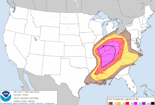
***DO NOT MINIMIZE YOUR RISK BASED ON INFORMATION BELOW***  Severe weather is expected all across Mississippi this afternoon.  The graphics in this post are estimates.  Do not interpret them as perfect predictions.

First - a TORNADO WATCH is in place until 9:00pm for the following Mississippi counties: 
     .    MISSISSIPPI COUNTIES INCLUDED ARE
     
     ALCORN               ATTALA              BENTON              
     CALHOUN              CARROLL             CHICKASAW           
     CHOCTAW              CLAY                GRENADA             
     HOLMES               HUMPHREYS           ITAWAMBA            
     LAFAYETTE            LEE                 LOWNDES             
     MARSHALL             MONROE              MONTGOMERY          
     NOXUBEE              OKTIBBEHA           PONTOTOC            
     PRENTISS             SHARKEY             TIPPAH              
     TISHOMINGO           UNION               WEBSTER             
     WINSTON              YALOBUSHA           YAZOO 


Additionally, a THUNDERSTORM WATCH is in effect until 9:00pm for the Western Delta counties


Storms are expected to develop along a boundary from Northeast Louisiana to the Golden Triangle area of Mississippi, starting between 2-4pm today.  These storms will progress southeast in the evening, gaining strength as they move.

A second line of storms can be expected to develop across the northwest Delta, particularly Bolivar, Washington, and Sunflower counties, sometime after 3pm.

From NWS Jackson -


From the Storm Prediction Center

Categorical Outlook for Friday:

Tornado outlook (illustrates chance of tornado within 25 miles of a given point)
Hail outlook (chance of hail within 25 miles of a given point)


Wind (chance of damaging winds within 25 miles of a given point)

***DO NOT USE THIS WEBSITE AS YOUR SOLE SOURCE OF WEATHER INFORMATION, ESPECIALLY WATCHES AND WARNINGS. THIS WEBSITE DELIVERS FOCUSED INFORMATION FOR A SPECIFIC GEOGRAPHIC AREA AND IS NOT INTENDED TO PROVIDE TIMELY WEATHER WARNING INFORMATION***

Hazardous Weather Outlook, Friday 3/2/12

HAZARDOUS WEATHER OUTLOOK
NATIONAL WEATHER SERVICE JACKSON MS
551 AM CST FRI MAR 2 2012 
 
MONTGOMERY & ATTALA COUNTIES 
THIS HAZARDOUS WEATHER OUTLOOK IS FOR PORTIONS OF NORTHEAST
LOUISIANA AND MUCH OF CENTRAL MISSISSIPPI. 

.DAY ONE...TODAY AND TONIGHT

SEVERE THUNDERSTORMS ARE EXPECTED TO DEVELOP LATER THIS AFTERNOON AND
TONIGHT ACROSS PARTS OF NORTHEAST LOUISIANA...NORTHERN AND CENTRAL
MISSISSIPPI. THERE WILL BE A COUPLE OF ROUNDS OF STORMS WITH THE
FIRST OCCURRING AHEAD OF THE FRONT STARTING AROUND 3PM. ADDITIONAL
SEVERE STORMS WILL OCCUR ALONG THE COLD FRONT AND AFFECT THE AREA
UNTIL 3AM. ANY STORMS WILL BE CAPABLE OF DAMAGING WINDS UP TO 75
MPH...HAIL UP TO GOLFBALL SIZE AND TORNADOES. A STRONG TORNADO COULD
ALSO OCCUR.

IN ADDITION...LOCALIZED HEAVY RAINFALL IS POSSIBLE...ESPECIALLY FROM
NATCHEZ TO DE KALB...WHERE THUNDERSTORMS MAY MOVE REPEATEDLY OVER THE
SAME AREA.

.DAYS TWO THROUGH SEVEN...SATURDAY THROUGH THURSDAY

THE PROBABILITY FOR WIDESPREAD HAZARDOUS WEATHER IS LOW.

BOLIVAR-SUNFLOWER-LEFLORE-GRENADA-CARROLL-WASHINGTON-HUMPHREYS-HOLMES
THIS HAZARDOUS WEATHER OUTLOOK IS FOR EXTREME SOUTHEAST
ARKANSAS...PORTIONS OF NORTHEAST LOUISIANA AND NORTHWEST MISSISSIPPI.

.DAY ONE...TODAY AND TONIGHT

SEVERE THUNDERSTORMS ARE EXPECTED TO DEVELOP LATE FRIDAY AFTERNOON
AND EVENING ALONG AN APPROACHING COLD FRONT. STORMS WILL LIKELY
OCCUR BETWEEN 4PM AND 8PM AND TRACK OFF TO THE SOUTH AND EAST THROUGH
THE EVENING. ALL SEVERE HAZARDS WILL BE POSSIBLE WITH THE STRONGEST
STORMS...WHICH INCLUDE DAMAGING WINDS TO 75 MPH...HAIL TO THE SIZE OF
GOLF BALLS...AND TORNADOES.

GUSTY SOUTH TO SOUTHWEST WINDS OF 25 MPH WITH GUSTS TO 40 MPH WILL
BE PRESENT TODAY AS A STRONG LOW PRESSURE SYSTEM MOVES NORTH OF THE
REGION AND THE PRESSURE GRADIENT TIGHTENS. THE STRONGEST WINDS WILL
OCCUR FROM 9AM TO 2PM. DUE TO THIS...A WIND ADVISORY IS IN EFFECT
THROUGH 4 PM.

.DAYS TWO THROUGH SEVEN...SATURDAY THROUGH THURSDAY

THE PROBABILITY FOR WIDESPREAD HAZARDOUS WEATHER IS LOW.

.SPOTTER CALL TO ACTION STATEMENT...
THE ACTIVATION OF STORM SPOTTERS...HAM RADIO OPERATORS...AND
EMERGENCY MANAGEMENT PERSONNEL IN SUPPORT OF SEVERE WEATHER
OPERATIONS WILL LIKELY BE NEEDED THIS AFTERNOON INTO TONIGHT. 


***DO NOT USE THIS WEBSITE AS YOUR SOLE SOURCE OF WEATHER INFORMATION, ESPECIALLY WATCHES AND WARNINGS. THIS WEBSITE DELIVERS FOCUSED INFORMATION FOR A SPECIFIC GEOGRAPHIC AREA AND IS NOT INTENDED TO PROVIDE TIMELY WEATHER WARNING INFORMATION***

Thursday, March 1, 2012

Storms for Friday, 3/2/2012

Another round of strong to severe thunderstorms are expected to develop over the Mississippi Delta on Friday afternoon, and progress south and east across Mississippi through the overnight hours.

Storms are expected to develop mid-afternoon, ahead of an advancing cold front.  While specific timing is uncertain, these storms may leave the Delta area by 5pm to 6pm.

Areas along and east of Interstate 55 have the highest risk for significant storms, including the possibility of hail, high winds, and tornadoes.

HAZARDOUS WEATHER OUTLOOK
NATIONAL WEATHER SERVICE JACKSON MS
545 AM CST THU MAR 1 2012

THIS HAZARDOUS WEATHER OUTLOOK IS FOR EXTREME SOUTHEAST
ARKANSAS...NORTHEAST LOUISIANA AND CENTRAL MISSISSIPPI.

.DAY ONE...TODAY AND TONIGHT

THE PROBABILITY FOR WIDESPREAD HAZARDOUS WEATHER IS LOW.

.DAYS TWO THROUGH SEVEN...FRIDAY THROUGH WEDNESDAY

SEVERE THUNDERSTORMS ARE EXPECTED TO DEVELOP LATE FRIDAY AFTERNOON
INTO FRIDAY NIGHT ALONG AND AHEAD OF A COLD FRONT MOVING THROUGH THE
REGION. ALL MODES OF SEVERE WEATHER WILL POSSIBLE INCLUDING DAMAGING
WINDS UP TO 70 MPH...LARGE HAIL UP TO GOLFBALL SIZE...AND TORNADOES.
SOME STRONG TORNADOES ARE POSSIBLE. WHILE ALL LOCATIONS WILL HAVE THE
POTENTIAL TO SEE THIS SEVERE WEATHER...LOCATIONS THAT ARE GENERALLY
ALONG AND EAST OF A LINE FROM PARCHMAN...TO VICKSBURG AND NORTH OF
INTERSTATE 20 WILL SEE AN ENHANCED RISK OF SEEING SIGNIFICANT SEVERE
STORMS. THE COLD FRONT WILL BE THROUGH THE REGION BY DAYBREAK
SATURDAY.

.SPOTTER CALL TO ACTION STATEMENT...
THE ACTIVATION OF STORM SPOTTERS...HAM RADIO OPERATORS...AND
EMERGENCY MANAGEMENT PERSONNEL IN SUPPORT OF SEVERE WEATHER
OPERATIONS WILL LIKELY BE NEEDED FRIDAY AFTERNOON INTO FRIDAY NIGHT.


***DO NOT USE THIS WEBSITE AS YOUR SOLE SOURCE OF WEATHER INFORMATION, ESPECIALLY WATCHES AND WARNINGS. THIS WEBSITE DELIVERS FOCUSED INFORMATION FOR A SPECIFIC GEOGRAPHIC AREA AND IS NOT INTENDED TO PROVIDE TIMELY WEATHER WARNING INFORMATION***