On the Air:
The radio was quiet for a week or so as I battled sinus issues. It's not easy to have QSO's when you've got little or no voice! By Christmas I was feeling better, and logged the following over the holidays:
Dec 23 - 5 QSOs, all PSK-31, one on 10 meters, four on 20 meters
Dec 27 - 15 QSOs, mixed PSK-31, Hellschreiber, SSB on 80, 20, and 17 meters
Dec 28 - 7 QSO's, one PSK-31 on 40 meters, and six JT65 on 20 and 40 meters. A special hat-tip to fellow blogger KD0BIK in Colorado, who's now in the log as my third JT65 contact
Dec 29 - 19 QSO's sizteen JT65, two PSK on 20 and 40 meters, and one FM 2 meter contact.
National & Regional
The Mississippi QSO Party has been scheduled for February 25, 2011. Rules are available at the Mississippi ARRL Section website, or directly at this link.
Local
The Delta A.R.E.S. Simplex Net will re-convene on January 1, 2012, after we skipped the Christmas holiday. If you're in the Mississippi Delta, join us on Sunday nights, 8:00pm Central Time, on 147.420 MHz, no tone needed.
The Mississippi ARRL Section will ring in the new year with a special-called Mississippi Section Phone Net, starting at 11:00pm (CST) on December 31, 2011, 3862 kHz. Drop by for a visit if you're on the air.
Around the Station:
I started using the JT65-HF operating mode this month, mainly out of curiosity. It's a slow mode, requiring about 6 to 7 minutes to complete a simple QSO of nothing more than signal reports. What makes JT65 interesting though, is that it doesn't require high power, and is very sensitive to weak signals, even signals below human hearing range. On my first night of operation with JT65, my signals were received in Russia, Sweden, Norway, the Netherlands, England, Switzerland, Italy, Spain, Argentina, Brazil, Venezuela, Curacao, and all across the United States on 40 and 20 meters, using 20 watts or less. (Country listing information retrieved from www.pskreporter.info.) The longest-distance reception report came from RN6AM in Krasnodar, Russia, 6168 miles away. I was transmitting 20 watts, which calculates to 308 miles-per-watt.
I received my ARRL Volunteer Examiner and W5YI Volunteer Examiner certification this month.
QSL Cards Received
W4DDK
QSL Cards Going Out
W1WAB - interesting story on this contact. William worked in the Hancock County (MS) Emergency Operations Center in the week or so after Hurricane Katrina. I was also there during that time, working for the State of Mississippi. I'm sure we crossed paths in the hall or cafeteria, but there were literally dozens of people there at that time. I met William on 20 meters, working PSK on December 23, where we exchanged brief Katrina stories. He's got information about his deployment with other Florida HAMs on www.sccarc.info/katrina.html.
WA8RPK
KD8JSP
KD2AIP
KD0NZY
KQ0J
AB9QU
W2FBS
K2CDP
AK4AT
KD0BIK - producer of the Practical Amateur Radio Podcast, I highly recommend it.
K0DSP
W2RON
NW5P
Until 2012....have a Happy (and safe) New Year!
73 de K5JAW
Saturday, December 31, 2011
Friday, December 30, 2011
2011 Review, 2012 Preview
As the year comes to an end, I've spent the last few days tending to my logs and catching up on QSL cards to send out. In doing so, I discovered that I've logged only 130 contacts (not counting regular nets that I participate in). That's only 2.5 contacts per week! What's worse is that almost half were in the month of December. I was more lazy with the radio than I thought!
2012 will remedy that. I'd considered taking on a QSO-365 Project, inspired by G6NHU in England, who's made at least one unique contact per day during the year. Work requires that I travel some, which would take me away from my station, thus making daily contacts difficult. In considering my own QSO-365, I thought of ways to work around being gone from time to time, including "banking" QSOs for use when I couldn't get on the air. I'd work in the spirit of the QSO-365 project, aiming for 365 contacts in the calendar year.
But after reviewing my pitiful logs for 2011 and previous years, I've come up with a different goal. Instead of working on daily contacts, I'm setting a goal of bringing my log up to 1000 contacts. As of this writing, there are 565 total contacts in my log, which means I'll have to make 435 contacts between now and January 1, 2013. That's three times the number of contacts from this year. I won't count regular net check-in's, but anything else logged under my call sign is fair game!
Other ideas for 2012 include participating in contests. I've never really cared for contesting, but I might be willing to give it a try in the new year. It's an aspect of amateur radio that I've obliquely participated in, giving the occasional report to stations who were contest participants. In 2009 I, somewhat accidentally, fell into an RTTY contest and logged 50 contacts in a day.
2012 Contests that are on my "might do" list:
ARRL RTTY Roundup - January 7-8
Mississippi QSO Party - February 25
ARRL Field Day - June 23 (not sure if I'll operate my own station, or as part of a club station)
There may be other contests to add to the list, but that's a fair start.
Other goals for 2012:
**Utilize this blog site for more amateur radio postings. The site was originally developed as a way to communicate pending severe weather information to a relatively small area of western Mississippi, but I've slowly expanded it to include my amateur radio operations. I'll post operating notes at least monthly, if not more often, outlining things going on around the shack.
**Become more vigilant about QSL status. I use ARRL's Logbook of the World, www.eqsl.cc, and regular paper QSL cards. My logbook automatically uploads to eqsl.cc when an entry is made, and I try to upload contacts to Logbook of the World at least monthly. Response rates for both online logging systems is around 30% (LOTW comes in at 26.6% confirmed QSOs, and eqsl.cc is at 31.2% confirmed QSOs). I don't send paper QSLs for each and every contact, simply because some operators don't QSL per their www.qrz.com information. I do send paper QSLs to contacts that I felt were notable, or otherwise highly desirable, such as some international contacts.
**Participate more in the National Traffic System (info here, and here). Not many messages are destined for my home county, which is fine, but there's no reason I can't put more messages into the system. Granted, in the day of instant messaging and email, some view the NTS as an archaic and slow means of sending a message across the country. But when the power is out and the cell system doesn't work, amateur radio operators in your area can get messages out in a timely manner. Sending birthday messages to out-of-state friends is one way to keep the practice and skill alive and functioning. If you're in my part of Mississippi and would like to send birthday, anniversary, or holiday greetings to someone, I'd be happy to help.
**Work towards getting an Extra Class license. My current General Class provides me access to large portions of all amateur radio bands. Some have said that the Extra Class test is a exponential leap in information and knowledge, just to gain a few kilohertz of band space. Maybe so, but it's a goal that I've let languish around in dusty corners of the shack for a few years. 2012 might just be the time to give it a try.
If you're an amateur radio operator, what are you goals for 2012? Please share them in the comments below.
Thanks to all the readers out there....maybe we'll find each other in the ether in 2012.
73 de K5JAW
Sunday, December 25, 2011
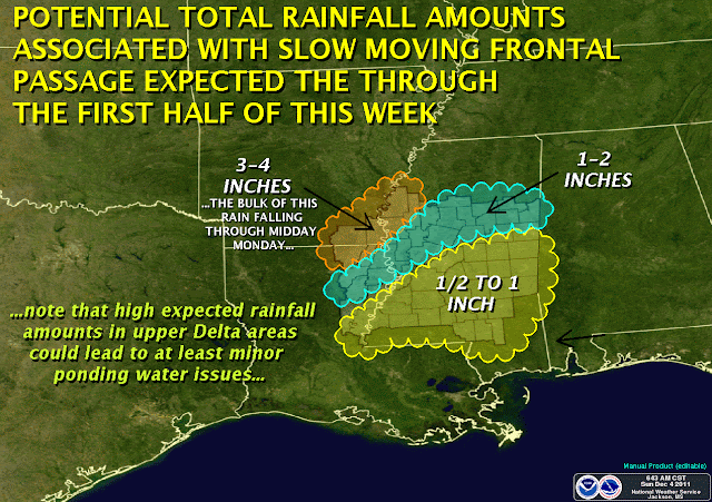
Wet Christmas, Part 2 (Update)
The rain forecast for today and Monday has changed slightly, with up to 4 inches of rain possible in some areas of the Delta. Travel safely over the holidays, and use caution on roads where water may be collected.

HAZARDOUS WEATHER OUTLOOK
NATIONAL WEATHER SERVICE JACKSON MS
501 AM CST SUN DEC 25 2011

THIS HAZARDOUS WEATHER OUTLOOK IS FOR CENTRAL MISSISSIPPI...
NORTHEAST LOUISIANA...AND EXTREME SOUTHEAST ARKANSAS.

.DAY ONE...TODAY AND TONIGHT

STEADY MODERATE TO HEAVY RAINS ONGOING AT THIS TIME AND THROUGH THIS
AFTERNOON WILL RESULT IN RAINFALL AMOUNTS OF 1 TO 2 INCHES. THESE
RAINFALL TOTALS WILL EFFECTIVELY SATURATE THE GROUND...LOW LYING
AREAS AND CREATE PONDING OF WATER ON ROADS. THE ADDITIONAL HEAVY
RAINFALL EXPECTED ON MONDAY WILL QUICKLY BECOME RUNOFF AND POSE AN
INCREASED FLASH FLOOD RISK.

.DAYS TWO THROUGH SEVEN...MONDAY THROUGH SATURDAY

A STRENGTHENING LOW PRESSURE SYSTEM AND ANOMALOUSLY HIGH MOISTURE WILL
COMBINE TO CREATE MODERATE TO HEAVY TRAINING RAIN SHOWERS AND
THUNDERSTORMS MONDAY THROUGH EARLY TUESDAY ACROSS MUCH OF THE
REGION. ADDITIONAL RAINFALL TOTALS OF 2 TO 3 INCHES WILL BE POSSIBLE.
COMBINED WITH RAINFALL AMOUNTS FROM SUNDAY...RAINFALL TOTALS NEARING 5
INCHES COULD POSSIBLE ACROSS SEVERAL AREAS OF THE ARKLAMISS REGION.
FLASH FLOODING WILL BECOME A CONCERN DURING THIS TIME FRAME BEFORE
RAIN TAPPERS DOWN TUESDAY MORNING.

.SPOTTER CALL TO ACTION STATEMENT...
THE ACTIVATION OF STORM SPOTTERS...HAM RADIO OPERATORS...AND
EMERGENCY MANAGEMENT PERSONNEL IN SUPPORT OF SEVERE WEATHER
OPERATIONS IS NOT EXPECTED THROUGH NEXT SATURDAY.

***DO NOT USE THIS WEBSITE AS YOUR SOLE SOURCE OF WEATHER INFORMATION, ESPECIALLY WATCHES AND WARNINGS. THIS WEBSITE DELIVERS FOCUSED INFORMATION FOR A SPECIFIC GEOGRAPHIC AREA AND IS NOT INTENDED TO PROVIDE TIMELY WEATHER WARNING INFORMATION***
Saturday, December 24, 2011
Christmas Message
NR 1201 R K5JAW ARL 3 INDIANOLA, MISS. DEC 24
READERS OF WWW.K5JAW.COM
ARL SIXTY ONE BT
JIM K5JAW
For you non-amateur radio folk, that says Wishing you a very Merry Christmas and a Happy New Year!
READERS OF WWW.K5JAW.COM
ARL SIXTY ONE BT
JIM K5JAW
For you non-amateur radio folk, that says Wishing you a very Merry Christmas and a Happy New Year!
Dreaming of a Wet Christmas...
No snow this Christmas for Mississippi, but it looks like we'll need to break out the waders and muck-boots as we go over the river and through the woods to grandmother's house....
Merry Christmas, everyone! Thanks for visiting here through the year. I hope the site has been useful to you, and look forward to bringing you more in 2012.

***DO NOT USE THIS WEBSITE AS YOUR SOLE SOURCE OF WEATHER INFORMATION, ESPECIALLY WATCHES AND WARNINGS. THIS WEBSITE DELIVERS FOCUSED INFORMATION FOR A SPECIFIC GEOGRAPHIC AREA AND IS NOT INTENDED TO PROVIDE TIMELY WEATHER WARNING INFORMATION***
Merry Christmas, everyone! Thanks for visiting here through the year. I hope the site has been useful to you, and look forward to bringing you more in 2012.
HAZARDOUS WEATHER OUTLOOK
NATIONAL WEATHER SERVICE JACKSON MS
612 AM CST SAT DEC 24 2011

THIS HAZARDOUS WEATHER OUTLOOK IS FOR CENTRAL MISSISSIPPI...
NORTHEAST LOUISIANA...AND EXTREME SOUTHEAST ARKANSAS.

.DAY ONE...TODAY AND TONIGHT

THE PROBABILITY FOR WIDESPREAD HAZARDOUS WEATHER IS LOW.

.DAYS TWO THROUGH SEVEN...SUNDAY THROUGH FRIDAY

A PROLONGED RAIN EVENT CAPABLE OF RAINFALL TOTALS BETWEEN 2 TO 4
INCHES BEGINNING EARLY SUNDAY AND LASTING THROUGH TUESDAY MORNING
WILL AFFECT MANY PORTIONS OF THE ARKLAMISS REGION. HIGH MOISTURE WILL
COMBINE WITH A DEEPENING LOW PRESSURE SYSTEM MOVING DIRECTLY OVER THE
REGION...RESULTING IN THE POTENTIAL FOR HEAVY TRAINING DOWNPOURS.
LOCALIZED FLOODING WILL BE POSSIBLE.

.SPOTTER CALL TO ACTION STATEMENT...
THE ACTIVATION OF STORM SPOTTERS...HAM RADIO OPERATORS...AND
EMERGENCY MANAGEMENT PERSONNEL IN SUPPORT OF SEVERE WEATHER
OPERATIONS IS NOT EXPECTED THROUGH NEXT FRIDAY.

***DO NOT USE THIS WEBSITE AS YOUR SOLE SOURCE OF WEATHER INFORMATION, ESPECIALLY WATCHES AND WARNINGS. THIS WEBSITE DELIVERS FOCUSED INFORMATION FOR A SPECIFIC GEOGRAPHIC AREA AND IS NOT INTENDED TO PROVIDE TIMELY WEATHER WARNING INFORMATION***
Wednesday, December 21, 2011
Wizardry: a great demonstration of Lenz’s Law!An induced...
From The NW7US Beacon:
Wizardry: a great demonstration of Lenz’s Law!
An induced electromotive force (emf) always gives rise to a current whose magnetic field opposes the original change in magnetic flux.
As the magnet moves through the copper pipe, an excellent conductor of electricity, the magnet is inducing a current in the pipe, in turn creating a secondary magnetic field that opposes the movement of the magnet down the pipe. This secondary field causes the magnet to slowly fall through the pipe.
Here is an explanation of Lenz’s Law:
Tuesday, December 20, 2011
NWS Releases reports on 2011 tornadoes
The National Weather Service recently released two reports on the Mississippi-Alabama-Georgia tornado outbreak of 2011, and the Joplin, Missouri tornado of May 22, 2011.
The Mississippi-Alabama-Georgia report can be found at http://www.nws.noaa.gov/os/assessments/pdfs/historic_tornadoes.pdf
The Joplin report can be found at http://www.nws.noaa.gov/os/assessments/pdfs/Joplin_tornado.pdf
The first report on the April 25-28, 2011 events, ranked as the third-worst tornado outbreak since 1950, provides a comprehensive review of the activities of various National Weather Service forecast offices across the states of Mississippi, Alabama, and Georgia. Interestingly, the weather service sought the support and input of social scientists when reviewing these events. Specifically, the weather service is acutely interested in how severe weather and tornado warnings are received by the community and how the warnings are acted upon.
The growth of smart-phone technology places a tremendous warning dissemination resource in the pockets of many. Even non-smart-phones that receive only calls and simple text messages can be a powerful tool. In the report on the April outbreak, the weather service found that "Peer warnings helped motivate people to take protective action. Nearby family and friends supplemented the warning system through personal contact," referring to friends and family using mobile communications technology to warn their neighbors and relatives of the oncoming storms. What does that mean? It means that you are a vital part of the warning chain. Don't hesitate pass information along, or assume that others are aware of warnings. A number of other "best practices" are offered in the report as well, some exclusive to the weather service, but many are applicable to the public.
A recurrent topic that is not limited to these two reports is that we should seek more than one source for weather warning information. NOAA Weather Radio provides a direct link from the weather service, but it is not infallible, as at least one NOAA transmitter was struck by an Alabama tornado. Utilizing multiple sources provides you the greatest potential to receive warnings in a timely manner.
Another salient point raised was the perception that people felt they needed personal, visual confirmation that a storm was going to affect them. The NWS strives to increase warning accuracy by carefully defining the warned area along the expected path of a storm. In waiting for visual confirmation of the imminent arrival of a tornado, persons in the path reduced their window of opportunity to seek shelter. In these cases, adequate warning lead-time had been given, yet people put themselves in unnecessary danger by "waiting to see."
Possibly the most important point to take from these reports is one that is not written in them. That point is that you are ultimately responsible for your actions before, during, and after a severe weather event. The National Weather Service, your county emergency management, your city public safety officials, and broadcast media can not provide you with instant, specific, and personalized instruction on how you should respond to an imminent weather emergency. Knowing how to receive warnings, how to interpret and react to them, and when, where, and how to take shelter are your life-saving responsibilities.
I encourage you to take some time to read through these reports, especially the sections that look at warning times, and public reception and actions based on the warnings.
Hazardous Weather Outlook for Tuesday, Dec 20, 2011
HAZARDOUS WEATHER OUTLOOK
NATIONAL WEATHER SERVICE JACKSON MS
606 AM CST TUE DEC 20 2011

THIS HAZARDOUS WEATHER OUTLOOK IS FOR WESTERN MISSISSIPPI...
NORTHEAST LOUISIANA...AND EXTREME SOUTHEAST ARKANSAS.

.DAY ONE...TODAY AND TONIGHT

STRONG TO SEVERE THUNDERSTORMS COULD DEVELOP THIS AFTERNOON AND
PERSIST INTO THE EARLY EVENING AS A LOW PRESSURE SYSTEM AND COLD
FRONT MOVE ACROSS THE AREA. ALL MODES OF SEVERE WEATHER WILL BE
POSSIBLE...INCLUDING DAMAGING WINDS UP TO 60 MPH...A FEW
TORNADOES...AND HAIL TO THE SIZE OF QUARTERS. THE RISK FOR SEVERE
WEATHER WILL GENERALLY BE GREATER FOR AREAS ALONG AND NORTH OF
INTERSTATE 20.

.DAYS TWO THROUGH SEVEN...WEDNESDAY THROUGH MONDAY

HEAVY RAINFALL OF ONE TO TWO INCHES WITH LOCALLY HIGHER AMOUNTS IS
EXPECTED TO DEVELOP LATE WEDNESDAY NIGHT AND PERSIST THROUGH MUCH OF
THURSDAY. PONDING OF WATER ISSUES WILL LIKELY MATERIALIZE AND
LOCALIZED FLASH FLOODING IS NOT OUT OF THE QUESTION IN LOCATIONS
EXPERIENCING THE HEAVIEST DOWNPOURS.

.SPOTTER CALL TO ACTION STATEMENT...
THE ACTIVATION OF STORM SPOTTERS...HAM RADIO OPERATORS...AND
EMERGENCY MANAGEMENT PERSONNEL IN SUPPORT OF SEVERE WEATHER
OPERATIONS MAY BE NECESSARY THIS AFTERNOON AND EVENING.
***DO NOT USE THIS WEBSITE AS YOUR SOLE SOURCE OF WEATHER INFORMATION, ESPECIALLY WATCHES AND WARNINGS. THIS WEBSITE DELIVERS FOCUSED INFORMATION FOR A SPECIFIC GEOGRAPHIC AREA AND IS NOT INTENDED TO PROVIDE TIMELY WEATHER WARNING INFORMATION***
Monday, December 19, 2011
Storms possible Tuesday, Dec 20, 2011
For the storms expected Tuesday, expect to see a broken line of storms move through the Delta area in the
afternoon and early evening hours. While there's no expectation of a widespread severe weather outbreak,
individual storms along the line, as well as discreet storms that form independently could bring significant winds
and the possibility of tornadoes to affected areas. Remain alert and stay tuned to NOAA Weather Radio and
local media outlets through the day for updated weather information.
It appears that the eastern half of Mississippi could see a better chance of organized severe weather later
Tuesday into Wednesday morning.
HAZARDOUS WEATHER OUTLOOK
NATIONAL WEATHER SERVICE JACKSON MS
104 PM CST MON DEC 19 2011

THIS HAZARDOUS WEATHER OUTLOOK IS FOR WESTERN MISSISSIPPI...
NORTHEAST LOUISIANA...AND EXTREME SOUTHEAST ARKANSAS.

.DAY ONE...TONIGHT THROUGH EARLY WEDNESDAY

SEVERE THUNDERSTORMS WILL BE POSSIBLE TUESDAY FROM 2PM TO 7PM. ALL
MODES OF SEVERE WEATHER WILL BE POSSIBLE...INCLUDING DAMAGING WINDS
UP TO 60 MPH...A FEW TORNADOES...AND HAIL TO THE SIZE OF QUARTERS.
THE RISK FOR SEVERE WEATHER WILL GENERALLY BE GREATER FOR AREAS
ALONG AND NORTH OF INTERSTATE 20 ON TUESDAY.

.DAYS TWO THROUGH SEVEN...WEDNESDAY THROUGH SUNDAY

HEAVY RAIN RESULTING IN RAINFALL TOTALS NEARING TWO INCHES WITH
LOCALLY HIGHER AMOUNTS COULD OCCUR ACROSS THE ARKLAMISS DELTA
THURSDAY AFTERNOON AND EVENING. EXCESSIVE TRAINING MAY BE ABLE TO
CREATE LOCALIZED FLASH FLOODING CONDITIONS...ESPECIALLY DEPENDING ON
HOW MUCH RAIN OCCURS ON TUESDAY. RAIN WILL END BY LATE THURSDAY
NIGHT.

.SPOTTER CALL TO ACTION STATEMENT...
THE ACTIVATION OF STORM SPOTTERS...HAM RADIO OPERATORS...AND
EMERGENCY MANAGEMENT PERSONNEL IN SUPPORT OF SEVERE WEATHER
OPERATIONS MAY BE NEEDED TUESDAY AFTERNOON THROUGH TUESDAY EVENING.


***DO NOT USE THIS WEBSITE AS YOUR SOLE SOURCE OF WEATHER INFORMATION, ESPECIALLY WATCHES AND WARNINGS. THIS WEBSITE DELIVERS FOCUSED INFORMATION FOR A SPECIFIC GEOGRAPHIC AREA AND IS NOT INTENDED TO PROVIDE TIMELY WEATHER WARNING INFORMATION***
Sunday, December 18, 2011
Update for Tuesday weather potential
HAZARDOUS WEATHER OUTLOOK
NATIONAL WEATHER SERVICE JACKSON MS
200 PM CST SUN DEC 18 2011
THIS HAZARDOUS WEATHER OUTLOOK IS FOR EXTREME SOUTHEAST
ARKANSAS...NORTHEAST LOUISIANA AND CENTRAL MISSISSIPPI...GENERALLY
ALONG AND NORTH OF INTERSTATE 20.

.DAY ONE...TONIGHT AND MONDAY

THE PROBABILITY FOR WIDESPREAD HAZARDOUS WEATHER IS LOW.

.DAYS TWO THROUGH SEVEN...MONDAY NIGHT THROUGH SATURDAY

SEVERE THUNDERSTORMS WILL BE POSSIBLE TUESDAY AND TUESDAY NIGHT AS A
STRONG LOW PRESSURE SYSTEM AND COLD FRONT MOVE ACROSS THE AREA. ALL
MODES OF SEVERE WEATHER WILL BE POSSIBLE...WHICH INCLUDE DAMAGING
WINDS UP TO 60 MPH...HAIL TO THE SIZE OF QUARTERS AND TORNADOES. THE
MAIN TIME PERIOD WILL BE FROM AROUND NOON TO 4 PM IN LOCATIONS WEST
OF THE INTERSTATE 55 CORRIDOR...AND FROM AROUND 3 PM TIL MIDNIGHT FOR
LOCATIONS EAST OF INTERSTATE 55.

.SPOTTER CALL TO ACTION STATEMENT...
THE ACTIVATION OF STORM SPOTTERS...HAM RADIO OPERATORS...AND
EMERGENCY MANAGEMENT PERSONNEL IN SUPPORT OF SEVERE WEATHER
OPERATIONS...MAY BE NEEDED TUESDAY AND TUESDAY NIGHT

***DO NOT USE THIS WEBSITE AS YOUR SOLE SOURCE OF WEATHER INFORMATION, ESPECIALLY WATCHES AND WARNINGS. THIS WEBSITE DELIVERS FOCUSED INFORMATION FOR A SPECIFIC GEOGRAPHIC AREA AND IS NOT INTENDED TO PROVIDE TIMELY WEATHER WARNING INFORMATION***
Saturday, December 17, 2011
Severe Weather Possible Tuesday, 12/20/2011
HAZARDOUS WEATHER OUTLOOK
NATIONAL WEATHER SERVICE JACKSON MS
154 PM CST SAT DEC 17 2011

THIS HAZARDOUS WEATHER OUTLOOK IS FOR CENTRAL MISSISSIPPI...
NORTHEAST LOUISIANA...AND EXTREME SOUTHEAST ARKANSAS.

.DAY ONE...TONIGHT AND SUNDAY

THE PROBABILITY FOR WIDESPREAD HAZARDOUS WEATHER IS LOW.

.DAYS TWO THROUGH SEVEN...SUNDAY NIGHT THROUGH FRIDAY

THERE IS A RISK FOR SEVERE THUNDERSTORMS TUESDAY WHEN A STRONG
LOW PRESSURE SYSTEM IS FORECAST TO MOVE ACROSS THE REGION. SOME
UNCERTAINTY REMAINS WITH THE TIMING AND INTENSITY OF THIS
SYSTEM...AND PERSONS IN THE ARKLAMISS SHOULD STAY TUNED FOR FURTHER
UPDATES.

.SPOTTER CALL TO ACTION STATEMENT...
THE ACTIVATION OF STORM SPOTTERS...HAM RADIO OPERATORS...AND
EMERGENCY MANAGEMENT PERSONNEL IN SUPPORT OF SEVERE WEATHER
OPERATIONS...MAY BE NEEDED TUESDAY.

***DO NOT USE THIS WEBSITE AS YOUR SOLE SOURCE OF WEATHER INFORMATION, ESPECIALLY WATCHES AND WARNINGS. THIS WEBSITE DELIVERS FOCUSED INFORMATION FOR A SPECIFIC GEOGRAPHIC AREA AND IS NOT INTENDED TO PROVIDE TIMELY WEATHER WARNING INFORMATION***
Friday, December 16, 2011
New Madrid, 200 Years Ago
Two hundred years ago today, December 16, 1811, the first two of several major earthquakes struck the New Madrid Seismic Zone. From that date through February 7, 1812, four major earthquakes were recorded, with intensity estimated as high as 8.1 on the Richter Scale. This series of quakes is the most powerful recorded in the Eastern United Sates. Church bells rang in Boston, and sidewalks cracked in Washington, D.C., as the vibration propagated through the earth.
The New Madrid Seismic Zone remains very active even today, with at least six recorded earthquakes in the past week.
Our vulnerability to earthquake damages are many. Unlike severe weather, damages from major earthquakes will be very widespread, and likely catastrophic in an order unknown in our society. Few first-hand accounts of the 1811-1812 events exist, and of those that do, most do not provide scientific data that would permit us to draw conclusions of what we might expect. Frequent experience with other hazards like severe weather, tornadoes, and hurricanes, provide us more frequent feedback about how well prepared we are, or are not. In the past two centuries, large cities and a multitude of smaller communities have built in and around the New Madrid Seismic Zone. Most were built with no knowledge of - or little attention given to - the need to build in seismic resistance. Our infrastructure of roadways and utility delivery pathways are vulnerable. A repeat of the 1811-1812 events would likely devastate the Memphis and/or St. Louis urban areas in a way that would make the sufferings wrought by Hurricane Katrina pale in comparison.
Doom and gloom isn't the point of this post. Awareness of your surroundings, and of the history that exists in our area provide you the opportunity to assess your own degree of readiness. Would you and your family be able to survive for one to two weeks without access to basic necessities? Even if roadways in your immediate area are passable, shipment of food and other commodities may be limited due to damage elsewhere. The 1811-1812 events occurred in the dead of winter. You may be able to shelter in your home, but if gas and electricity are interrupted for days, can you stave off the cold?
There are innumerable resources for you to research ways for your family to prepare for disasters. Learn what hazards exist in your area, and ask yourself how would you be affected by those hazards. Even though your home may not be impacted, what are your options if supply lines are interrupted? What are your plans to communicate to family and friends outside the affected area?
Web resource for the New Madrid Seismic Area and the New Madrid Bicentennial can be found at www.newmadrid2011.org.
Preparedness Information
www.ready.gov
US Geological Survey - Earthquake Information
USGS Handbook for Earthquakes in the Central United States (PDF file, 24.8 MB)
FEMA Earthquake Preparedness page
The Great Central US ShakeOut (Feb 7, 2012)
Monday, December 12, 2011
Dense Fog Advisory for Tonight, Tomorrow (12/12-13/2011)
URGENT - WEATHER MESSAGE
NATIONAL WEATHER SERVICE JACKSON MS
236 PM CST MON DEC 12 2011

LAZ009-016-023>026-MSZ025>033-035>066-072>074-130445-
/O.NEW.KJAN.FG.Y.0011.111213T0600Z-111213T1700Z/
EAST CARROLL-MADISON LA-FRANKLIN LA-CATAHOULA-TENSAS-CONCORDIA-
LEFLORE-GRENADA-CARROLL-MONTGOMERY-WEBSTER-CLAY-LOWNDES-CHOCTAW-
OKTIBBEHA-HUMPHREYS-HOLMES-ATTALA-WINSTON-NOXUBEE-ISSAQUENA-
SHARKEY-YAZOO-MADISON MS-LEAKE-NESHOBA-KEMPER-WARREN-HINDS-RANKIN-
SCOTT-NEWTON-LAUDERDALE-CLAIBORNE-COPIAH-SIMPSON-SMITH-JASPER-
CLARKE-JEFFERSON-ADAMS-FRANKLIN MS-LINCOLN-LAWRENCE-
JEFFERSON DAVIS-COVINGTON-JONES-MARION-LAMAR-FORREST-
236 PM CST MON DEC 12 2011

...DENSE FOG ADVISORY IN EFFECT FROM MIDNIGHT TONIGHT TO 11 AM
CST TUESDAY...

THE NATIONAL WEATHER SERVICE IN JACKSON HAS ISSUED A DENSE FOG
ADVISORY...WHICH IS IN EFFECT FROM MIDNIGHT TONIGHT TO 11 AM CST
TUESDAY.

FOG IS EXPECTED TO DEVELOP LATER THIS EVENING WITH DENSE FOG FORMING
AFTER MIDNIGHT AND DURING THE OVERNIGHT HOURS WHILE LINGERING INTO
MID MORNING TUESDAY.

* VISIBILITY: FREQUENTLY ONE QUARTER MILE OR LESS.

* IMPACTS: REDUCED VISIBILITIES WILL CREATE HAZARDOUS DRIVING
  CONDITIONS THROUGH THE OVERNIGHT AND EARLY MORNING HOURS.


PRECAUTIONARY/PREPAREDNESS ACTIONS...

A DENSE FOG ADVISORY MEANS VISIBILITIES WILL FREQUENTLY BE REDUCED TO
LESS THAN ONE QUARTER MILE. IF DRIVING...SLOW DOWN...USE YOUR
HEADLIGHTS...AND LEAVE PLENTY OF DISTANCE AHEAD OF YOU.
***DO NOT USE THIS WEBSITE AS YOUR SOLE SOURCE OF WEATHER INFORMATION, ESPECIALLY WATCHES AND WARNINGS. THIS WEBSITE DELIVERS FOCUSED INFORMATION FOR A SPECIFIC GEOGRAPHIC AREA AND IS NOT INTENDED TO PROVIDE TIMELY WEATHER WARNING INFORMATION***
Thursday, December 8, 2011
Operating Notes, 12/9/2011
On The Air:
National & Regional:
Santa Claus will take to the HF airwaves as we get closer to Christmas. If you've got a youngster who would enjoy talking with Santa via amateur radio, then take a look at these articles, and tune in:
Santa Net Special Event W2HO - Orange County Amateur Radio Club, Newburgh, NY on December 10, 2030Z to 2300Z, 7200 kHz and 3920 kHz. More info can also be found at the club's website http://www.ocarc-ny.org.
Santa on The Freewheelrs and The Tailgaters nets (Voice of Ham Radio, KE5GGY blog). December 13th, 15th, 19th, 21st, 23rd, and 24th 8:30 - 9:00 PM Central time, 3916 kHz.
Local:
Stations around the Mississippi Delta have been experimenting with Slow-Scan TV (SSTV) on 2 meters FM, at 145.510 MHz. SSTV gives us a means to transmit color or black-and-white images over the air to another amateur station. While the images are generally routine, the technology can be useful to get low resolution images of disaster damage when other means of communication are unavailable.
QSL Cards received this week:
K5ZRK
Outgoing QSL Cards from K5JAW:
UR8MH - Ukraine
PY3ED - Brazil
P43E - Aruba
ON4CAS - Belgium
OH7UE - Finland
MI0SAI - Northern Ireland
JA2XYO - Japan
IZ8QIX - Italy
IZ2JPN - Italy
IZ1PKV - Italy
HP3HSG - Panama
F4FFH - France
F4BKV - France
FO5QB - French Polynesia
EA8CDJ -Canary Islands
HK5/EA4AAZ -Spanish station operating in Colombia
CT1CDP - Portugal
ZL3NB - New Zealand
Tuesday, December 6, 2011
Cold blast tonight & Wednesday
It looks like we'll see a cold blast of air tonight and Wednesday morning, with a slight chance of frozen precipitation across then northern portion of the state. A 50% chance of snow/sleet mix overnight, diminishing to 30% in the morning. Little to no accumulation is expected, but use caution when crossing bridges on the way to work Wednesday morning. (click the picture for animated version)

***DO NOT USE THIS WEBSITE AS YOUR SOLE SOURCE OF WEATHER INFORMATION, ESPECIALLY WATCHES AND WARNINGS. THIS WEBSITE DELIVERS FOCUSED INFORMATION FOR A SPECIFIC GEOGRAPHIC AREA AND IS NOT INTENDED TO PROVIDE TIMELY WEATHER WARNING INFORMATION***

***DO NOT USE THIS WEBSITE AS YOUR SOLE SOURCE OF WEATHER INFORMATION, ESPECIALLY WATCHES AND WARNINGS. THIS WEBSITE DELIVERS FOCUSED INFORMATION FOR A SPECIFIC GEOGRAPHIC AREA AND IS NOT INTENDED TO PROVIDE TIMELY WEATHER WARNING INFORMATION***
Sunday, December 4, 2011
Amateur Radio Blogroll
I've started reading (via RSS) a number of other amateur radio operator blogs. Here's the current blogroll:
KB9MWR - Advancing Ham Radio
KC4BQK - The Future is Digital Communication
N5FDL's EMCOMM Journal - Amateur Radio & Emergency Communications
AI4WM Amateur Radio Blog
KD0BIK Amateur Radio Weblog (also producer of the Practical Amateur Radio Podcast)
KC5FM...focuses on Social Media in Emergency Management
K2DBK's Ham Radio Blog
KB6NU's Ham Radio Blog
K0NR: Radio Enthusiast
The NW7US Beacon
K9ZW With Varying Frequency - Amateur Radio Ponderings
Drop by these fine operators and enjoy their musings about the ether.
Wet Weather Update
The advancing cold front is moving slower than I originally thought, which means our rains won't start until mid-day today (as opposed to overnight last night). After the front passes, look for temperatures to fall through the week, to the mid-40's for highs, and mid-30's for lows around Wednesday, with continued clouds. Thursday should see a return of sunshine with highs in the 50's, but the clear skies will mean very cold nights toward the weekend.
Be careful for your Monday and Tuesday commute, as locally heavy rainfall can result in ponding of water on the roadway. Give yourself a little extra driving time, and get there safely!

Be careful for your Monday and Tuesday commute, as locally heavy rainfall can result in ponding of water on the roadway. Give yourself a little extra driving time, and get there safely!

***DO NOT USE THIS WEBSITE AS YOUR SOLE SOURCE OF WEATHER INFORMATION, ESPECIALLY WATCHES AND WARNINGS. THIS WEBSITE DELIVERS FOCUSED INFORMATION FOR A SPECIFIC GEOGRAPHIC AREA AND IS NOT INTENDED TO PROVIDE TIMELY WEATHER WARNING INFORMATION***
Saturday, December 3, 2011
Operating Notes - Dec 3, 2011
Enjoyed a good morning on the air for the National Weather Service's SKYWARN Recognition Day. NWS Stations logged today were:
K8DTX - NWS White Lake, Michigan (Detroit)
KC0NWS - NWS Central Region Headquarters, Kansas City, Missouri
N0W - NWS Grand Junction, Colorado (Special Event Callsign)
N7PI - NWS Pocatello, Idaho
W9NWS - NWS Indianapolis, Indiana
WX0GLD - NWS Goodland, Kansas
WX4MLB - NWS Melbourne, Florida
WX4NWS - NWS Louisville, Kentucky
WX4RNK - NWS Blacksburg, Virginia
WX5AMA - NWS Amarillo, Texas
WX5EWX - NWS Austin, Texas
WX5HGX - NWS Houston, Texas
WX5JAN - NWS Jackson, Mississippi
WX8GRR - NWS Grand Rapids, Michigan
WX8WIL - NWS Wilmington, Ohio
WX9ARX - NWS La Crosse, Wisconsin
WX9ILS - NWS Lincoln, Illinois
International Stations logged today:
EA5BZ - Ruben in Elche, Spain, 4873 miles
CX5BW - Pedro in Uruguay, 5208 miles
Friday, December 2, 2011
K5JAW Operating Notes - Dec 2, 2011
Busy week, not much radio time....
Plan to be on the air for the National Weather Service SKYWARN Recognition Day 2011. Amateur Radio enjoys a good relationship with the National Weather Service, and on-air events like this raise the radio community's awareness and interest in our mutually beneficial programs.
QSL cards are in the mail to: HI3/KL7JR, KE8YB, W4DDK, K5ZRK and NA1SS. More will be mailed out next week to international stations.
73, de K5JAW
Wet, Wet Weekend ahead
It looks like the weekend will turn soggy sometime Saturday night, and lasting into Tuesday. Relatively heavy rainfall amounts are expected as a cold front passes through the area. The graphics below show what we might expect.


***DO NOT USE THIS WEBSITE AS YOUR SOLE SOURCE OF WEATHER INFORMATION, ESPECIALLY WATCHES AND WARNINGS. THIS WEBSITE DELIVERS FOCUSED INFORMATION FOR A SPECIFIC GEOGRAPHIC AREA AND IS NOT INTENDED TO PROVIDE TIMELY WEATHER WARNING INFORMATION***


***DO NOT USE THIS WEBSITE AS YOUR SOLE SOURCE OF WEATHER INFORMATION, ESPECIALLY WATCHES AND WARNINGS. THIS WEBSITE DELIVERS FOCUSED INFORMATION FOR A SPECIFIC GEOGRAPHIC AREA AND IS NOT INTENDED TO PROVIDE TIMELY WEATHER WARNING INFORMATION***
Monday, November 28, 2011
Winter Weather?
There's a slim chance that the Delta area could see snow mixed with rain overnight, but no accumulation is expected due to warmer ground temperatures. Light amounts of accumulation on elevated surfaces and grassy areas could be seen north of a line from Carrollton to Macon, MS.
For the remainder of the week, expect daytime temperatures around 50 for Tuesday and Wednesday. Wednesday night into Thursday morning will be the coldest we've seen this fall, with lows around 22 to 27 degrees expected.
Our next best chance of rain will be Sunday or Monday of the coming week.

For the remainder of the week, expect daytime temperatures around 50 for Tuesday and Wednesday. Wednesday night into Thursday morning will be the coldest we've seen this fall, with lows around 22 to 27 degrees expected.
Our next best chance of rain will be Sunday or Monday of the coming week.
HAZARDOUS WEATHER OUTLOOK
NATIONAL WEATHER SERVICE JACKSON MS
140 PM CST MON NOV 28 2011

THIS HAZARDOUS WEATHER OUTLOOK IS FOR CENTRAL MISSISSIPPI...
NORTHEAST LOUISIANA...AND EXTREME SOUTHEAST ARKANSAS.

.DAY ONE...TONIGHT AND TUESDAY

LIGHT RAIN TONIGHT MAY MIX WITH AND EVEN CHANGE OVER TO LIGHT SNOW
ACROSS LOCATIONS MAINLY NORTH OF A ROLLING FORK TO CARTHAGE TO DE
KALB MISSISSIPPI LINE...ESPECIALLY AFTER MIDNIGHT. THERE COULD BE A
LIGHT DUSTING OF SNOW ON ELEVATED SURFACES AND IN GRASSY AREAS EARLY
TUESDAY. AS A WORSE CASE...LOCATIONS ALONG AND NORTH OF A GRENADA TO
KOSCIUSKO TO MACON LINE MAY RECEIVE UP TO ONE INCH. HOWEVER...IF THAT
OCCURS...NO IMPACT ON ROADWAYS IS EXPECTED DUE TO THE WARM GROUND
CONDITIONS.

.DAYS TWO THROUGH SEVEN...TUESDAY NIGHT THROUGH SUNDAY

THE PROBABILITY FOR WIDESPREAD HAZARDOUS WEATHER IS LOW.

.SPOTTER CALL TO ACTION STATEMENT...
THE ACTIVATION OF STORM SPOTTERS...HAM RADIO OPERATORS...AND
EMERGENCY MANAGEMENT PERSONNEL IN SUPPORT OF SEVERE WEATHER
OPERATIONS IS NOT EXPECTED THROUGH NEXT SUNDAY.

***DO NOT USE THIS WEBSITE AS YOUR SOLE SOURCE OF WEATHER INFORMATION, ESPECIALLY WATCHES AND WARNINGS. THIS WEBSITE DELIVERS FOCUSED INFORMATION FOR A SPECIFIC GEOGRAPHIC AREA AND IS NOT INTENDED TO PROVIDE TIMELY WEATHER WARNING INFORMATION***
Saturday, November 26, 2011
Catching Up...
I've spent the better part of the day cleaning up my radio log book, and WOW...discovered I'm way behind on sending out contact confirmations. QSL cards represent a written confirmation of contact between two amateur radio stations. The traditional card has been in use for just shy of one hundred years. With the advent and prevalence of the internet, and computerized logging systems, a lot of QSL'ing is now done electronically through various online systems. At my station, I use two online systems, and get a fair amount of feedback through them. It's quick, easy, and free.
However, there's something missing from a simple online confirmation. Getting a printed card in the mail from other amateur radio operators in far-flung locations is far more fulfilling. Instead of an electronic notification, the QSL card includes that personal contact - handwriting, pictures, tidbits of interesting information - from someone in another land.
I've relied exclusively on electronic confirmation for too long. It's time to put my hand back to my own cards, and send them out to the world. Cards to Portugal, the Canary Islands, French Polynesia, France, Panama, Italy, Japan, Northern Ireland, Finland, Aruba, Brazil, Ukraine, New Zealand and the Dominican Republic will be sent, along with cards to closer to home in Mississippi, South Carolina, and West Virginia.
UPDATED Hazardous WX Outlook for Nov 26, 2011
UPDATED at 2:45pm

***DO NOT USE THIS WEBSITE AS YOUR SOLE SOURCE OF WEATHER INFORMATION, ESPECIALLY WATCHES AND WARNINGS. THIS WEBSITE DELIVERS FOCUSED INFORMATION FOR A SPECIFIC GEOGRAPHIC AREA AND IS NOT INTENDED TO PROVIDE TIMELY WEATHER WARNING INFORMATION***
HAZARDOUS WEATHER OUTLOOK
NATIONAL WEATHER SERVICE JACKSON MS
205 PM CST SAT NOV 26 2011

THIS HAZARDOUS WEATHER OUTLOOK IS FOR SOUTHEAST ARKANSAS...NORTHEAST
LOUISIANA...AND MUCH OF CENTRAL AND SOUTHERN MISSISSIPPI.

.DAY ONE...TODAY AND TONIGHT
A BAND OF STRONG TO ISOLATED SEVERE THUNDERSTORMS WILL MOVE ACROSS
THE REGION LATE THIS AFTERNOON AND TONIGHT AHEAD OF A SLOW MOVING
COLD FRONT. WIND GUSTS TO 60 MPH WILL BE THE MAIN SEVERE WEATHER
THREAT...BUT A TORNADO COULD ALSO BE POSSIBLE. THE MAIN BAND OF
THUNDERSTORMS IS EXPECTED TO AFFECT AREAS ALONG AND WEST OF THE
MISSISSIPPI RIVER BETWEEN 3 AND 7 PM...BE ALONG THE INTERSTATE 55
CORRIDOR BETWEEN 8 AND 11 PM...AND BE OVER EASTERN MISSISSIPPI
BETWEEN 11 PM AND 4 AM.

.DAYS TWO THROUGH SEVEN...SUNDAY THROUGH FRIDAY
THE PROBABILITY OF WIDESPREAD HAZARDOUS WEATHER IS LOW.

.SPOTTER CALL TO ACTION STATEMENT...
THE ACTIVATION OF STORM SPOTTERS...HAM RADIO OPERATORS...AND
EMERGENCY MANAGEMENT PERSONNEL IN SUPPORT OF SEVERE WEATHER
OPERATIONS...COULD BE NEEDED THIS AFTERNOON AND TONIGHT.
***DO NOT USE THIS WEBSITE AS YOUR SOLE SOURCE OF WEATHER INFORMATION, ESPECIALLY WATCHES AND WARNINGS. THIS WEBSITE DELIVERS FOCUSED INFORMATION FOR A SPECIFIC GEOGRAPHIC AREA AND IS NOT INTENDED TO PROVIDE TIMELY WEATHER WARNING INFORMATION***
Hazardous Weather Outlook, Saturday, Nov 26, 2011
HAZARDOUS WEATHER OUTLOOK
NATIONAL WEATHER SERVICE JACKSON MS
542 AM CST SAT NOV 26 2011
**THIS HAZARDOUS WEATHER OUTLOOK IS FOR PORTIONS OF CENTRAL
MISSISSIPPI...NORTHEAST LOUISIANA...AND EXTREME SOUTHEAST ARKANSAS
(Highway 82 Corridor).

STRONG THUNDERSTORMS CAPABLE OF PRODUCING WIND GUSTS OF 40
TO 50 MPH WILL BE POSSIBLE LATE THIS AFTERNOON AND EVENING. THESE
STORMS ARE EXPECTED TO DEVELOP ALONG AND AHEAD OF A COLD FRONT THAT
WILL BE MOVING ACROSS THE REGION. THE COLD FRONT IS EXPECTED TO BE
JUST EAST OF THE MISSISSIPPI RIVER BY MIDNIGHT AND SOUTHEAST OF THE
OUTLOOK AREA WELL BEFORE SUNRISE.

**THIS HAZARDOUS WEATHER OUTLOOK IS FOR PORTIONS OF CENTRAL
MISSISSIPPI AND EAST CENTRAL LOUISIANA (Interstate 20 Corridor and south).

.DAY ONE...TODAY AND TONIGHT

STRONG TO SEVERE STORMS WILL BE POSSIBLE FROM LATE THIS AFTERNOON
THROUGH TONIGHT ALONG AND JUST AHEAD OF A STRONG COLD FRONT THAT WILL
BE MOVING ACROSS THE REGION. WIND GUSTS TO 60 MPH WILL BE THE MAIN
THREAT BUT A TORNADO OR TWO WILL ALSO BE POSSIBLE. THE COLD FRONT IS
EXPECTED TO BE NEAR THE MISSISSIPPI RIVER BY MIDNIGHT AND BE OVER
SOUTHEAST MISSISSIPPI BY SUNRISE SUNDAY MORNING.

.DAYS TWO THROUGH SEVEN...SUNDAY THROUGH FRIDAY

THE PROBABILITY FOR WIDESPREAD HAZARDOUS WEATHER IS LOW.

.SPOTTER CALL TO ACTION STATEMENT...
THE ACTIVATION OF STORM SPOTTERS...HAM RADIO OPERATORS...AND
EMERGENCY MANAGEMENT PERSONNEL IN SUPPORT OF SEVERE WEATHER
OPERATIONS...MAY BE NEEDED LATER THIS AFTERNOON AND TONIGHT.


***DO NOT USE THIS WEBSITE AS YOUR SOLE SOURCE OF WEATHER INFORMATION, ESPECIALLY WATCHES AND WARNINGS. THIS WEBSITE DELIVERS FOCUSED INFORMATION FOR A SPECIFIC GEOGRAPHIC AREA AND IS NOT INTENDED TO PROVIDE TIMELY WEATHER WARNING INFORMATION***
Thursday, November 24, 2011
60 Meter Band Changes Proposed
The FCC recently published changes to the 60-Meter band. The entire Report & Order can be found here. Or click here for a PDF version. The American Radio Relay League's article on the changes can be found here. As of Thursday morning, 11/24/2011, the Report & Order had not been published in the Federal Register. The rule changes will not take effect until 30 days after publication.
Various articles on this change can be found on www.eham.com, www.60meters.net, here, here, here, here, and here.
Under the new plan, the 60 meter band 5MHz Channel List will be:
5330.5 kHz USB (center of channel 5332.0)
5346.5 kHz USB (center of channel 5348.0)
5357.0 kHz USB (center of channel 5358.5)
5371.5 kHz USB (center of channel 5373.0)
5403.5 kHz USB (center of channel 5405.0)
Monday, November 21, 2011
Hazardous Weather Outlook for Tuesday Nov 22, 2011
As promised, here is the most current thinking on the potential for severe weather on Tuesday, 11/22/2011
As a cold front approaches western Mississippi early tomorrow, a line of thunderstorms will develop along the front. Additionally, there is the potential for discrete thunderstorms to develop independently ahead of the frontal boundary. Hail, high winds and locally heavy rainfall are all possible with these storms. Tornado development cannot be ruled out as these storms pass.
Storm development is expected to begin in the western portions of Mississippi around daybreak, from 6am through noon. Areas along the Natchez Trace corridor should see storms move through between 11am and 5pm, and finally areas of southeastern Mississippi will see the front pass through between 3pm and midnight. The greatest potential for severe weather development is expected to be south of a line from Grenada, Mississippi, to Morehouse Parish, Louisiana. While this indicates less risk for the western portion of the Mississippi Delta (Bolivar, Sunflower, Washington counties), readers in those area should remain alert to developing weather conditions.
Illustrative graphics can be found below the hazardous weather outlook.
HAZARDOUS WEATHER OUTLOOK
NATIONAL WEATHER SERVICE JACKSON MS
311 PM CST MON NOV 21 2011

THIS HAZARDOUS WEATHER OUTLOOK IS FOR CENTRAL MISSISSIPPI...
NORTHEAST LOUISIANA...AND EXTREME SOUTHEAST ARKANSAS.

.DAY ONE...TONIGHT THROUGH TUESDAY

SEVERE THUNDERSTORMS WILL BE POSSIBLE TUESDAY INTO TUESDAY EVENING.
THE PRIMARY HAZARD WITH THESE STORMS WILL BE DAMAGING WINDS...BUT
TORNADOES AND LARGE HAIL WILL ALSO BE POSSIBLE. A SQUALL LINE IS
EXPECTED TO DEVELOP ALONG AND JUST AHEAD OF A COLD FRONT EARLY
TUESDAY AND PROGRESS EASTWARD. THE LINE IS EXPECTED TO MOVE INTO
THE WESTERN PORTIONS OF THE AREA BY MID MORNING...THE CENTRAL
PORTIONS OF THE AREA DURING THE AFTERNOON...AND EXIT THE SOUTHEAST
TUESDAY EVENING. ALTHOUGH THE SEVERE STORMS WILL BE POSSIBLE OVER THE
WHOLE OUTLOOK AREA...THE AREA ALONG AND EAST OF A LINE FROM WINNSBORO
LOUISIANA TO GRENADA MISSISSIPPI APPEARS TO HAVE THE GREATEST CHANCE
OF EXPERIENCING SEVERE STORMS TUESDAY.

.DAYS TWO THROUGH SEVEN...TUESDAY NIGHT THROUGH SUNDAY

THE PROBABILITY FOR WIDESPREAD HAZARDOUS WEATHER IS LOW.

.SPOTTER CALL TO ACTION STATEMENT...
THE ACTIVATION OF STORM SPOTTERS...HAM RADIO OPERATORS...AND
EMERGENCY MANAGEMENT PERSONNEL IN SUPPORT OF SEVERE WEATHER
OPERATIONS...WILL LIKELY BE NEEDED TUESDAY INTO TUESDAY EVENING.


***DO NOT USE THIS WEBSITE AS YOUR SOLE SOURCE OF WEATHER INFORMATION, ESPECIALLY WATCHES AND WARNINGS. THIS WEBSITE DELIVERS FOCUSED INFORMATION FOR A SPECIFIC GEOGRAPHIC AREA AND IS NOT INTENDED TO PROVIDE TIMELY WEATHER WARNING INFORMATION***
Stand by for updates for Tuesday's weather
As of this morning, there's no real new information concerning the possibility of severe weather for Tuesday, Nov 22. We'll be on a conference call with the weather service this afternoon, and will post more information following that call.
Sunday, November 20, 2011
Severe weather possible Tuesday, 11/22/2011
It looks like we'll have another opportunity for severe weather this week, Tuesday and Tuesday evening. A cold front is expected to move through the region on Tuesday. A line of severe thunderstorms are expected to develop ahead of this front as it moves into the Delta around mid-day. The line should pass through the south-east portion of Mississippi around midnight Tuesday night. Forecasters expect the air mass ahead of the front to be unstable enough to produce severe isolated storms ahead of the squall line. These isolated thunderstorms and the later squall line could produce hail, damaging winds, and possibly tornadoes. With a moisture-rich air mass in place, locally heavy rains are also possible.
I'll have more information around mid-afternoon on Monday, and will keep this site updated. As always, precise predictions this far in advance are almost impossible, but computer models have been in agreement since Friday on this potential for Tuesday. Below you'll find today's Hazardous Weather Outlook as well as some graphics from the National Weather Service office in Jackson, as well as the Storm Prediction Center in Oklahoma.
Remember, November is our "second season" for severe weather and tornadoes in Mississippi. Please keep abreast of changing weather conditions by monitoring local media outlets and NOAA Weather Radio.
 Below graphic is Day-3 (Tuesday) Probabilistic Outlook. This depicts the probability of severe weather within 25 miles of any given point.

I'll have more information around mid-afternoon on Monday, and will keep this site updated. As always, precise predictions this far in advance are almost impossible, but computer models have been in agreement since Friday on this potential for Tuesday. Below you'll find today's Hazardous Weather Outlook as well as some graphics from the National Weather Service office in Jackson, as well as the Storm Prediction Center in Oklahoma.
Remember, November is our "second season" for severe weather and tornadoes in Mississippi. Please keep abreast of changing weather conditions by monitoring local media outlets and NOAA Weather Radio.
HAZARDOUS WEATHER OUTLOOK
NATIONAL WEATHER SERVICE JACKSON MS
209 PM CST SUN NOV 20 2011

THIS HAZARDOUS WEATHER OUTLOOK IS FOR PORTIONS OF CENTRAL MISSISSIPPI...NORTHEAST
LOUISIANA AND EXTREME SOUTHEAST ARKANSAS.

.DAY ONE...TONIGHT AND MONDAY

THE PROBABILITY FOR WIDESPREAD HAZARDOUS WEATHER IS LOW.

.DAYS TWO THROUGH SEVEN...MONDAY NIGHT THROUGH SATURDAY

SEVERE THUNDERSTORMS WILL BE POSSIBLE TUESDAY INTO TUESDAY EVENING. THESE
STORMS WILL HAVE THE POTENTIAL FOR DAMAGING WINDS...HAIL AND
TORNADOES. GULF MOISTURE WILL CONTINUE TO PUSH INTO THE AREA TO
PRODUCE AN UNSTABLE AIR MASS THAT WILL BE IN PLACE WHEN A STRONG COLD
FRONT MOVES ACROSS THE REGION EARLY THIS WEEK. LOCALLY HEAVY RAINFALL
WILL ALSO BE POSSIBLE WITH THE STORMS. PLEASE CONTINUE TO MONITOR
THE LATEST FORECASTS AND OUTLOOKS FOR UPDATES ON THIS DEVELOPING
WEATHER EPISODE.

.SPOTTER CALL TO ACTION STATEMENT...
THE ACTIVATION OF STORM SPOTTERS...HAM RADIO OPERATORS...AND
EMERGENCY MANAGEMENT PERSONNEL IN SUPPORT OF SEVERE WEATHER
OPERATIONS...WILL BE NEEDED FOR TUESDAY AND TUESDAY NIGHT.


***DO NOT USE THIS WEBSITE AS YOUR SOLE SOURCE OF WEATHER INFORMATION, ESPECIALLY WATCHES AND WARNINGS. THIS WEBSITE DELIVERS FOCUSED INFORMATION FOR A SPECIFIC GEOGRAPHIC AREA AND IS NOT INTENDED TO PROVIDE TIMELY WEATHER WARNING INFORMATION***
Thursday, November 17, 2011
Severe Weather Survey
The National Weather Service offices in Jackson and Memphis have collaborated with Mississippi State University to develop a survey on the reception of, and response to severe weather warnings in Mississippi and surrounding states. The NWS offices plan to use the information gathered in this survey to improve their warnings, services, and severe weather educational efforts.
Clicking here will carry you to an online version of the survey. Your responses will not be associated with your name, so anonymity is assured.
NWS Jackson excels in their relationship with Mississippi's emergency management community. Their forecasters work very closely with your local emergency planners to provide you the most timely and reliable information possible. Please take a few moments to complete this survey and help them continue to improve their services. Feel free to share the survey link to friends and relatives, too. You may see this survey link posted in other social media such as Facebook and Twitter. You only need to participate in the survey once.
Tuesday, November 15, 2011
Updated Hazardous Weather Outlook for tonight, 11/15/2011
HAZARDOUS WEATHER OUTLOOK
NATIONAL WEATHER SERVICE JACKSON MS
246 PM CST TUE NOV 15 2011

THIS HAZARDOUS WEATHER OUTLOOK IS FOR EXTREME SOUTHEAST
ARKANSAS...NORTHEAST LOUISIANA AND PORTIONS OF CENTRAL MISSISSIPPI
WEST OF THE INTERSTATE 55 CORRIDOR.

.DAY ONE...TONIGHT AND WEDNESDAY

STRONG TO SEVERE STORMS WILL BE POSSIBLE THIS EVENING INTO THE EARLY
OVERNIGHT HOURS AS AN UPPER DISTURBANCE MOVES ACROSS THE REGION.
ENOUGH INSTABILITY AND WIND SHEAR WILL BE PRESENT FOR WINDS UP TO 60
MPH AND A WEAK TORNADO CANNOT BE RULED OUT. THE MAIN TIMEFRAME FOR
THIS ACTIVITY WILL BE FROM AROUND 8 PM TO 2 AM.

.DAYS TWO THROUGH SEVEN...WEDNESDAY NIGHT THROUGH MONDAY

THE PROBABILITY FOR WIDESPREAD HAZARDOUS WEATHER WILL BE LOW.

.SPOTTER CALL TO ACTION STATEMENT...
THE ACTIVATION OF STORM SPOTTERS...HAM RADIO OPERATORS...AND
EMERGENCY MANAGEMENT PERSONNEL IN SUPPORT OF SEVERE WEATHER
OPERATIONS...MAY BE NEEDED THIS EVENING INTO TONIGHT BUT OTHERWISE
IS NOT EXPECTED THROUGH NEXT MONDAY.


Storm Prediction Center Tornado outlook for tonight & tomorrow

***DO NOT USE THIS WEBSITE AS YOUR SOLE SOURCE OF WEATHER INFORMATION, ESPECIALLY WATCHES AND WARNINGS. THIS WEBSITE DELIVERS FOCUSED INFORMATION FOR A SPECIFIC GEOGRAPHIC AREA AND IS NOT INTENDED TO PROVIDE TIMELY WEATHER WARNING INFORMATION***
Hazardous Weather Outlook 11/15/2011, 10:30am
It appears the timing for today's storms may have shifted to later afternoon and overnight. Some areas of South Mississippi are starting to see rain showers this morning. Eastern areas of the state should start experiencing rain later in the afternoon. Western areas could see the development of storms through midnight overnight, and possibly into Wednesday morning.

 Storm Prediction Center's outlook for severe weather today

Storm Prediction Center Tornado Outlook for today

Storm Prediction Center Wind Outlook for today

HAZARDOUS WEATHER OUTLOOK
NATIONAL WEATHER SERVICE JACKSON MS
513 AM CST TUE NOV 15 2011

THIS HAZARDOUS WEATHER OUTLOOK IS FOR EXTREME SOUTHEAST
ARKANSAS...NORTHEAST LOUISIANA AND PORTIONS OF CENTRAL MISSISSIPPI.

.DAY ONE...TODAY AND TONIGHT

STRONG TO SEVERE THUNDERSTORMS WILL BE POSSIBLE TONIGHT THROUGH MID
MORNING WEDNESDAY AS A FRONTAL SYSTEM AND ATMOSPHERIC DISTURBANCE
AFFECT THE REGION. THE MAIN RISK WITH ANY SEVERE STORMS WILL BE WIND
GUSTS TO 60 MPH...BUT A TORNADO OR TWO CANNOT BE RULED OUT
CONSIDERING THE EXPECTED PRESENCE OF STRONG ATMOSPHERIC WIND SHEAR.

.DAYS TWO THROUGH SEVEN...WEDNESDAY THROUGH MONDAY

THE RISK OF ANY STRONG TO SEVERE THUNDERSTORMS SHOULD BE DIMINISHING
QUICKLY BY MIDDAY WEDNESDAY.

.SPOTTER CALL TO ACTION STATEMENT...
THE ACTIVATION OF STORM SPOTTERS...HAM RADIO OPERATORS...AND
EMERGENCY MANAGEMENT PERSONNEL IN SUPPORT OF SEVERE WEATHER
OPERATIONS...MAY BE NEEDED TONIGHT THROUGH WEDNESDAY MORNING...BUT IS
OTHERWISE NOT ANTICIPATED THROUGH NEXT MONDAY.


Storm Prediction Center Tornado Outlook for today

Storm Prediction Center Wind Outlook for today

***DO NOT USE THIS WEBSITE AS YOUR SOLE SOURCE OF WEATHER INFORMATION, ESPECIALLY WATCHES AND WARNINGS. THIS WEBSITE DELIVERS FOCUSED INFORMATION FOR A SPECIFIC GEOGRAPHIC AREA AND IS NOT INTENDED TO PROVIDE TIMELY WEATHER WARNING INFORMATION***
Monday, November 14, 2011
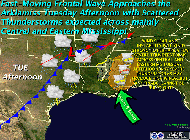
Hazardous Weather Outlook, Tuesday 11/15/2011
Tuesday afternoon and evening could see the development of strong to severe thunderstorms over a good portion of Mississippi. Timing and severity are difficult to predict right now, as several variables are in play, including daytime heating & instability development, wind shear, and the amount of moisture available. Right now, it looks like areas along and east of Interstate 55 will see the first development of rains Tuesday afternoon, then storms in western areas of the state will follow later in the day. Rainfall amounts, however, should remain relatively low in any given location.


HAZARDOUS WEATHER OUTLOOK
NATIONAL WEATHER SERVICE JACKSON MS
230 PM CST MON NOV 14 2011

THIS HAZARDOUS WEATHER OUTLOOK IS FOR CENTRAL MISSISSIPPI...
NORTHEAST LOUISIANA...AND EXTREME SOUTHEAST ARKANSAS.

.DAY ONE...TONIGHT AND TUESDAY

THE PROBABILITY FOR WIDESPREAD HAZARDOUS WEATHER IS LOW.

.DAYS TWO THROUGH SEVEN...TUESDAY NIGHT THROUGH SUNDAY

STRONG TO SEVERE THUNDERSTORMS WILL DEVELOP TUESDAY NIGHT. THE
PRIMARY HAZARD WITH THESE STORMS WILL BE DAMAGING WIND GUSTS TO 60
MPH BUT WEAK TORNADOES CAN NOT BE RULED OUT.

THE FEED OF GULF MOISTURE INTO THE REGION WILL INCREASE AHEAD OF A
LOW PRESSURE SYSTEM THAT WILL MOVE INTO THE AREA TUESDAY EVENING.
THE AIR MASS WILL REMAIN MARGINALLY UNSTABLE BUT STRONG WIND SHEAR
THAT WILL DEVELOP AHEAD OF THE FRONT WILL BE SUFFICIENT TO SUPPORT
THE POTENTIAL FOR STRONG TO SEVERE STORMS.

.SPOTTER CALL TO ACTION STATEMENT...
THE ACTIVATION OF STORM SPOTTERS...HAM RADIO OPERATORS...AND
EMERGENCY MANAGEMENT PERSONNEL IN SUPPORT OF SEVERE WEATHER
OPERATIONS MAY BE NEEDED TUESDAY NIGHT.


***DO NOT USE THIS WEBSITE AS YOUR SOLE SOURCE OF WEATHER INFORMATION, ESPECIALLY WATCHES AND WARNINGS. THIS WEBSITE DELIVERS FOCUSED INFORMATION FOR A SPECIFIC GEOGRAPHIC AREA AND IS NOT INTENDED TO PROVIDE TIMELY WEATHER WARNING INFORMATION***
Thursday, November 10, 2011
Ham Radio in the 21st Century
Great article over at Electronics Design, Strategy and News on Ham Radio in the 21st Century. Click and read an interesting piece.
Freeze Warning Tonight - Nov 10-11, 2011
URGENT - WEATHER MESSAGE
NATIONAL WEATHER SERVICE JACKSON MS
408 AM CST THU NOV 10 2011

...COLD TEMPERATURES EXPECTED LATE TONIGHT INTO FRIDAY MORNING...

...FREEZE WARNING IN EFFECT FROM MIDNIGHT TONIGHT TO 8 AM CST
FRIDAY...

THE NATIONAL WEATHER SERVICE IN JACKSON HAS ISSUED A FREEZE
WARNING...WHICH IS IN EFFECT FROM MIDNIGHT TONIGHT TO 8 AM CST
FRIDAY.

* TIMING: TEMPERATURES ACROSS THE ARKLAMISS REGION WILL DROP DOWN
  INTO THE MID AND UPPER 30S AFTER MIDNIGHT TONIGHT. MANY LOCATIONS
  WILL LATER FALL TO OR JUST BELOW THE FREEZING MARK FOR A FEW HOURS
  BEFORE 8 AM FRIDAY MORNING. CONFIDENCE IN FREEZING AND BELOW
  FREEZING TEMPERATURES IS HIGHEST IN SHELTERED AND RURAL AREAS.

* IMPACTS: SHORT TERM EXPOSURE TO FREEZING TEMPERATURES WILL HAVE THE
  POTENTIAL TO DAMAGE NON HARDY VEGETATION. IN ADDITION...SOME PETS
  UNACCUSTOMED TO THE COLD COULD BE NEGATIVELY IMPACTED IF LEFT
  OUTDOORS THROUGH THE NIGHT.

PRECAUTIONARY/PREPAREDNESS ACTIONS...

A FREEZE WARNING MEANS SUB-FREEZING TEMPERATURES ARE IMMINENT OR
HIGHLY LIKELY. THESE CONDITIONS WILL KILL CROPS AND OTHER
SENSITIVE VEGETATION.
***DO NOT USE THIS WEBSITE AS YOUR SOLE SOURCE OF WEATHER INFORMATION, ESPECIALLY WATCHES AND WARNINGS. THIS WEBSITE DELIVERS FOCUSED INFORMATION FOR A SPECIFIC GEOGRAPHIC AREA AND IS NOT INTENDED TO PROVIDE TIMELY WEATHER WARNING INFORMATION***
Wednesday, November 9, 2011
National Emergency Alert System (EAS) Test - Nov 9, 2011 at 1:00pm CST
Open Letter: Nationwide Emergency Alert System Test
Posted by: Craig Fugate, Administrator, Federal Emergency Management Agency and Julius Genachowski, Chairman, Federal Communications CommissionThe first ever nationwide test of the Emergency Alert System will occur on Wednesday, November 9, at 2:00 p.m. EST. As part of our public education campaign, we wrote this open letter to ensure that all Americans are aware of the test and know what to expect.
Please share this information with your friends, family, and coworkers:
Dear Partner,
As part of our nation’s ongoing efforts to strengthen our resilience against all hazards, the Federal Emergency Management Agency (FEMA) and the Federal Communications Commission (FCC), in close coordination with the National Oceanic and Atmospheric Association (NOAA), will conduct the first ever nationwide test of the Emergency Alert System on Wednesday, November 9, at 2:00 p.m. EST. The test will occur simultaneously across the United States and the U.S. territories and will last approximately 30 seconds, after which regular programming will resume. The test will appear on all broadcast radio and television stations, cable television systems, satellite radio and television systems, and wireline video service systems. The test will not involve landline or mobile phones or other infrastructure such as power grids.
The various disasters our country has faced this year underscore the need for effective and well-tested emergency alert and warning systems that could be used in a time of real national emergency, at a moment’s notice. Now, with the test less than a week away, we ask that you join us in efforts to educate your entire community about this important event.
Although the Emergency Alert System and its predecessors have been in existence for more than 50 years and are often tested at the local level, there has never been a nationwide test of these capabilities. The purpose of the test is to allow FEMA and the FCC to assess how well the Emergency Alert System would perform its primary function: alerting the public about a national emergency.
The first step toward building a modernized Emergency Alert System means testing the existing technology. Through preparations for the test, we have already identified areas that need improvement to ensure our entire population has full access to alerts and warnings. This nationwide test will help us identify any additional changes to the system that may be beneficial as we work to complete a modernized and fully accessible system.
A shortcoming of the system that we identified early in the process is that the fifty-year old system was not built to support open or closed captioning, translations, or other tools to supplement the audio portion of the test for broader accessibility. Consequently, many viewers, particularly cable television subscribers, will see the emergency alert on the screen that is accompanied by an audio explanation that "this is only a test," but may not see a corresponding visual message that "this is only a test." Knowing these limitations, FEMA and the FCC have targeted our outreach efforts to help ensure that the public knows what to expect when the test occurs. And, in these past weeks leading up to the test, the broadcast community, cable operators and programmers, and other communications service providers have conscientiously assisted in this effort by alerting their viewers and subscribers about the test—through visual and written communications.
Over the past year, our agencies have also been working extensively with our state, local, tribal, and territorial partners, and other critical stakeholders to help inform all members of the public regarding the nationwide Emergency Alert System test. In particular, we have conducted extensive outreach to the deaf and hard of hearing community to alert them about the test, including the technical limitations with the visual message, particularly with respect to cable television. To ensure that everyone is aware that the nationwide test on November 9 is only a test, we are also requesting your assistance with outreach. We particularly request that you provide information to people who are deaf and hard of hearing, people with cognitive or intellectual disabilities or mental health concerns, senior citizens, and people with limited English proficiency to build awareness and understanding about the test.
Specifically, we ask that you help us educate your communities regarding some important facts about the test:
- The test will be approximately 30 seconds long and will look and sound very similar to the frequent local tests of the Emergency Alert System;
- It will be transmitted via television and radio stations within the U.S., including Alaska, Hawaii, the territories of Puerto Rico, the U.S. Virgin Islands, and American Samoa;
- An audio message will interrupt television and radio programming indicating: “This is only a test,” though text may not indicate this same message on the screen on every television channel;
- Organizations that serve people with disabilities or people with limited English proficiency should be aware that they may receive requests for information or assistance from broadcasters or other communications service providers and emergency managers in the days leading up to, during, and after the test; and
- When the test is over, regular programming will resume. In the coming days, our agencies will be releasing additional information to help inform the public about this test. Resources, including videos in accessible formats, can be found at www.fema.gov/eastest.
As with all of our work, we know that the support of our state, local, tribal and territorial partners, along with the private sector, our faith-based and disability communities, and other key stakeholders, will be vital to effectively raising the public’s awareness of the test and minimizing undue public concern. We greatly appreciate your continued partnership as we prepare for this unique event and important public service. Your efforts to help us get the message out will be invaluable.
Sincerely,
W. Craig Fugate
ADMINISTRATOR
Federal Emergency Management Agency
Julius Genachowski
CHAIRMAN
Federal Communications Commission
***DO NOT USE THIS WEBSITE AS YOUR SOLE SOURCE OF WEATHER INFORMATION, ESPECIALLY WATCHES AND WARNINGS. THIS WEBSITE DELIVERS FOCUSED INFORMATION FOR A SPECIFIC GEOGRAPHIC AREA AND IS NOT INTENDED TO PROVIDE TIMELY WEATHER WARNING INFORMATION***
Tuesday, November 8, 2011
**UPDATED** Hazardous Weather Outlook - Nov 8, 2011
**UPDATED at 3:30pm**

***DO NOT USE THIS WEBSITE AS YOUR SOLE SOURCE OF WEATHER INFORMATION, ESPECIALLY WATCHES AND WARNINGS. THIS WEBSITE DELIVERS FOCUSED INFORMATION FOR A SPECIFIC GEOGRAPHIC AREA AND IS NOT INTENDED TO PROVIDE TIMELY WEATHER WARNING INFORMATION***
HAZARDOUS WEATHER OUTLOOK
NATIONAL WEATHER SERVICE JACKSON MS
215 PM CST TUE NOV 8 2011

THIS HAZARDOUS WEATHER OUTLOOK IS FOR PORTIONS OF CENTRAL
MISSISSIPPI...NORTHEAST LOUISIANA AND EXTREME SOUTHEAST ARKANSAS.

.DAY ONE...TONIGHT AND WEDNESDAY

A FEW STRONG TO SEVERE THUNDERSTORMS WILL BE POSSIBLE BETWEEN 10 PM
AND 1 AM AS A WEAKENING SQUALL LINE SWEEPS EAST ACROSS THE REGION AHEAD
OF A COLD FRONT. THE PRIMARY RISK WITH THIS ACTIVITY WILL BE
DAMAGING WIND GUSTS UP TO 60 MPH.

.DAYS TWO THROUGH SEVEN...WEDNESDAY NIGHT THROUGH MONDAY

A LIGHT FREEZE WILL BE POSSIBLE EARLY FRIDAY MORNING AS HIGH PRESSURE
SETTLES OVER THE REGION IN THE PRESENCE OF CLEAR SKIES AND LIGHT
WINDS. PRECAUTIONS SHOULD BE TAKEN TO PROTECT OUTDOOR ANIMALS AND
SENSITIVE VEGETATION.

.SPOTTER CALL TO ACTION STATEMENT...
THE ACTIVATION OF STORM SPOTTERS...HAM RADIO OPERATORS...AND
EMERGENCY MANAGEMENT PERSONNEL IN SUPPORT OF SEVERE WEATHER
OPERATIONS...MAY BE NEEDED TONIGHT.

***DO NOT USE THIS WEBSITE AS YOUR SOLE SOURCE OF WEATHER INFORMATION, ESPECIALLY WATCHES AND WARNINGS. THIS WEBSITE DELIVERS FOCUSED INFORMATION FOR A SPECIFIC GEOGRAPHIC AREA AND IS NOT INTENDED TO PROVIDE TIMELY WEATHER WARNING INFORMATION***
Hazardous Weather Outlook - Nov 8, 2011
HAZARDOUS WEATHER OUTLOOK
NATIONAL WEATHER SERVICE JACKSON MS
449 AM CST TUE NOV 8 2011

THIS HAZARDOUS WEATHER OUTLOOK IS FOR PORTIONS OF CENTRAL
MISSISSIPPI...NORTHEAST LOUISIANA...AND EXTREME SOUTHEAST ARKANSAS.

.DAY ONE...TODAY AND TONIGHT

STRONG TO SEVERE THUNDERSTORMS WILL BE POSSIBLE THIS EVENING INTO EARLY
WEDNESDAY MORNING AHEAD OF A COLD FRONT THAT WILL BE CROSSING THE
REGION. THE PRIMARY RISK WILL BE WIND GUSTS UP TO 60 MPH FOR
LOCATIONS GENERALLY NORTHWEST OF A ACME LOUISIANA...TO VICKSBURG...TO
GRENADA MISSISSIPPI LINE WITH A WEAKENING SQUALL LINE THAT LIKELY
WILL SWEEP EAST WITH THE FRONT. OTHERWISE...THE PROBABILITY FOR
WIDESPREAD HAZARDOUS WEATHER WILL BE LOW.

.DAYS TWO THROUGH SEVEN...WEDNESDAY THROUGH MONDAY

A LIGHT FREEZE WILL BE POSSIBLE LATE THURSDAY NIGHT AS HIGH PRESSURE
SETTLES OVER THE REGION IN THE PRESENCE OF CLEAR SKIES AND LIGHT
WINDS.

.SPOTTER CALL TO ACTION STATEMENT...
THE ACTIVATION OF STORM SPOTTERS...HAM RADIO OPERATORS...AND
EMERGENCY MANAGEMENT PERSONNEL IN SUPPORT OF SEVERE WEATHER
OPERATIONS...MAY BE NEEDED TONIGHT.

***DO NOT USE THIS WEBSITE AS YOUR SOLE SOURCE OF WEATHER INFORMATION, ESPECIALLY WATCHES AND WARNINGS. THIS WEBSITE DELIVERS FOCUSED INFORMATION FOR A SPECIFIC GEOGRAPHIC AREA AND IS NOT INTENDED TO PROVIDE TIMELY WEATHER WARNING INFORMATION***
Sunday, November 6, 2011
Hazardous Weather for Tuesday, Nov 8
HAZARDOUS WEATHER OUTLOOK
NATIONAL WEATHER SERVICE JACKSON MS
138 PM CST SUN NOV 6 2011

THIS HAZARDOUS WEATHER OUTLOOK IS FOR CENTRAL MISSISSIPPI...
NORTHEAST LOUISIANA...AND EXTREME SOUTHEAST ARKANSAS.

.DAY ONE...TONIGHT AND MONDAY

THE PROBABILITY FOR WIDESPREAD HAZARDOUS WEATHER IS LOW.

.DAYS TWO THROUGH SEVEN...MONDAY NIGHT THROUGH SATURDAY

STRONG THUNDERSTORMS WILL BE POSSIBLE TUESDAY EVENING INTO EARLY
WEDNESDAY MORNING AHEAD OF A COLD FRONT THAT WILL BE CROSSING THE REGION.
THE PRIMARY RISK WILL BE WIND GUSTS UP TO 50 MPH FOR LOCATIONS
GENERALLY NORTHWEST OF A ACME LOUISIANA...TO VICKSBURG...TO GRENADA
MISSISSIPPI LINE WITH A WEAKENING SQUALL LINE THAT LIKELY WILL SWEEP
EAST WITH THE FRONT. OTHERWISE...THE PROBABILITY FOR WIDESPREAD
HAZARDOUS WEATHER WILL BE LOW.

.SPOTTER CALL TO ACTION STATEMENT...
THE ACTIVATION OF STORM SPOTTERS...HAM RADIO OPERATORS...AND
EMERGENCY MANAGEMENT PERSONNEL IN SUPPORT OF SEVERE WEATHER
OPERATIONS IS NOT EXPECTED THROUGH NEXT SATURDAY.
***DO NOT USE THIS WEBSITE AS YOUR SOLE SOURCE OF WEATHER INFORMATION, ESPECIALLY WATCHES AND WARNINGS. THIS WEBSITE DELIVERS FOCUSED INFORMATION FOR A SPECIFIC GEOGRAPHIC AREA AND IS NOT INTENDED TO PROVIDE TIMELY WEATHER WARNING INFORMATION***
Thursday, October 20, 2011
Preparedness: The Big Book
Disaster preparedness and planning can be a complex, lengthy, and sometimes expensive endeavor. Communities, states, and federal authorities constantly refine their plans for response and recovery. Mitigation projects like flood control systems and building codes help reduce the potential effects of disasters. Preparedness requires that we acquire and maintain supplies, equipment, and trained personnel in a state of readiness. While our governing authorities do what they can, there remains one area of preparedness that no governmental entity can address: you and your family's own personal state of readiness. By undertaking a family disaster planning project, you can reduce your household's potential demands on your community's response. By extension, the more well-prepared families there are, the more prepared the overall community is.
There are dozens of resources online to guide you through various aspects of personal disaster preparedness. www.ready.gov is a great place to find basic information on disaster kits, food and water supply ideas, and other simple steps you can take.
While food, water, clothing, and shelter are absolutely essential to survival, I want to use this blog entry to remind you that following the immediate threats of an emergency, information is as essential to your recovery as the items previously mentioned.
A highly useful tool that I'm adding to my family's growing emergency plan is The Big Book of Everything, compiled by Erik A. Dewey. Clicking that link will take you to a page where you can download either an Adobe PDF, or Microsoft Excel version of The Big Book.
The Big Book may seem daunting at first, but by compiling the information in incremental steps over the period of a few weeks, you'll develop a comprehensive document that details emergency information such as family contacts, as well as capturing important financial and other critical data.
What do you do with all this valuable - and sensitive - information? I wouldn't recommend having a printed copy laying around the house for burglars to find your banking information. Instead, print out only those essential pages that contain emergency points of contact, and keep it safely stored in a location known by all family members.
An option that we're exploring is storing a non-editable PDF version of The Big Book on key-shaped flash drives. These won't occupy valuable space in your pocket, but will allow you to keep vital information easily accessible. Yes, it is sensitive data. But you can easily encrypt it using a very lightweight program called TrueCrypt, for which the price is right: it's absolutely free. We'll also store scanned copies of important documents in that encrypted file as well. If you wish, it may be helpful to have a non-encrypted version of The Big Book on your jump drive. Just redact any information that could be used should the drive become lost. (Think CIA black pen marks - just black out the sensitive information on Excel then save it as a PDF).
We'll most likely have multiple copies of these flash drives, distributed out to family members both locally and non-local. Twice a year (or more often if needed) they'll be collected and updated as information changes.
Why go through this exercise? We have the capacity to digitize a huge portion of our lives, for relatively little cost. I have several years worth of bank records, payroll records, and other documents stored digitally in multiple locations. In the unlikely event that a disaster requires our evacuation, consider how much time we would save by not having to identify, find, collect, and store the paper documents. Digital copies will never replace certified originals. Having volumes of information compressed into something the size of my house key, easily portable and securely encrypted will give my family the chance of a less-stressful recovery should we need it.
The Big Book isn't - and shouldn't be - your family's entire disaster plan. It is just one part of a multifaceted plan that includes out-of-town/state contacts, pre-determined family evacuation locations (in town, out of town), basic food & water supplies, and emergency action steps for specific hazards like fires and thunderstorms. The Big Book does, however, give you a one-stop-shop for a host of critical information that you'll wish you had.
What's your plan?
Subscribe to:
Posts (Atom)