FLASH FLOODING: Flash floods can occur within a few minutes or up to 6 hours after excessive rainfall, a dam or levee failure, or a sudden release of water held by an ice jam or mud slide. Flash floods can wash out roads, destroy buildings an d bridges. Because flash floods happen in a short period of time (less than six hours after the causative event) they are more life threatening than other types of flooding. Areas most susceptible to flash flooding are mountainous streams and rivers, urban areas, low-lying areas, storm drains, and culverts.
A Flash Flood Warning is issued when flash flooding has been reported or is imminent. It focuses on specific communities, creeks or streams, or other geographic areas where flooding is imminent or occurring.
RIVER FLOODING: This type of flooding is caused by an increased water level in established watercourses, such as a rivers, creeks, or streams. River flooding is slower to develop than flash flooding (more than 6 hours after the causative event), however, some smaller creeks and streams have a short lag time between the runoff from heavy rain and the onset of flooding. On the other hand, it may take several days for a flood crest to pass downstream points on major rivers such as the Lower Pearl, and Mississippi Rivers. The NWS issues River Flood Warnings when rivers are expected to rise above flood stage. Persons in the warned area are advised to take necessary precautions immediately. River stages and crest forecasts are given for selected forecast points along with known flood stages for each forecast point. While there is usually more advanced warning time with river floods than with flash floods, persons should be familiar with the flood prone areas they live and work in, and must know what action to take and where to go if a flood occurs. Advance planning and preparation is essential.
FLOOD SAFETY RULES: Follow these tips to stay safe during flood conditions…
When a warning is issued get out of areas subject to flooding. These may include dips, low spots, stream beds, drainage ditches and culverts. If caught in low areas during flooding, go to high ground immediately.
Avoid already flooded and high velocity flow areas. A rapidly flowing stream or ditch can sweep you off your feet or even carry your car or truck downstream. Never drive through a flooded area as the road bed may be washed away. Play it safe! If you encounter a flooded road - TURN AROUND, DON’T DROWN!
Be especially cautious at night when it is harder to recognize flood conditions, and never drive around a barricaded road.
Most flood deaths occur at night and when people become trapped in automobiles that stall in areas that are flooded. If your vehicle stalls, abandon it immediately and seek higher ground. The rising water may engulf the vehicle and the occupants inside. Do not camp or park your vehicle along streams or washes during threatening conditions.
When a FLOOD WARNING is issued for your area, act quickly to save yourself. You may only have seconds!
**Source: National Weather Service - Jackson, MS Forecast Office, Mississippi Severe Weather Awareness Week 2011 Brochure which can be viewed/downloaded by clicking the link.
Tuesday, February 22, 2011


Monday, February 21, 2011
Severe Weather Awareness Week - Severe Thunderstorms
Each day this week, we'll post information on various aspects of severe weather for Severe Weather Awareness Week 2011. Feel free copy, paste, or share this information. Today, we discuss severe thunderstorms and hail.
What is a Severe Thunderstorm?
A severe thunderstorm is a thunderstorm that produces one or more of the following: hail that has a diameter of one inch (quarter size) or larger, winds greater than or equal to 58 mph, and tornadoes. About 10% of all thunderstorms in the U.S. meet severe criteria.
Severe thunderstorms can occur at any time of year, although the most common time of occurrence is during the spring months of March, April, and May. In addition, pulse-type thunderstorms during the summer months can produce high winds, frequent lightning, and torrential downpours.
There is also a secondary season of organized severe weather in Mississippi, in November and early December.
What is the Difference between a Watch and a Warning?
A severe thunderstorm watch means that conditions are favorable for severe thunderstorms to develop. These are issued by the Storm Prediction Center in Norman, OK, typically before severe weather is developing.
A severe thunderstorm warning means that a severe thunderstorm has either been indicated on radar or witnessed by storm spotters. Your local NWS Forecast Office issues severe thunderstorm warnings when severe weather is developing or occurring.
How Is Hail Formed?
Hail is formed when water droplets are drawn into an area of strong upward moving air, known as an up-
draft, of a storm. Once the water droplets are transported above the freezing level, they combine with tiny airborne particles, such as dirt, salt, volcanic ash, etc., and freeze on contact, forming tiny ice particles. These ice particles are light enough that they remain suspended in the cloud, where they undergo processes that allow them to combine with other supercooled water droplets and grow into hail stones. Once the hail stones are heavy enough to overcome the upward force of the updraft, they fall out of the cloud. By definition, hail stones are 5 millimeters or larger, and can inflict significant damage to automobiles, buildings, crops, and even people.
Mississippi's primary season for significant hail (1 inch or larger) runs from March to May, but hail is possible year-round.
As of January 5, 2010, the National Weather Service has changed the severe hail criteria from 3/4 inch to 1 inch. Why the change? There are a couple of reasons. Research has shown that significant damage caused by hail does not occur until the hail diameter reaches one inch (approximately quarter size) or larger. Requests from NWS partners such as emergency managers and the media further prompted the decision to increase the severe hail criteria due to the fact that more frequent severe thunderstorm warnings may act to desensitize the public from their meaningfulness. Such an effect could cause people not to take caution during such a warning, which could lead to unnecessary damage or injury. The change means that severe thunderstorm warnings for hail will be issued less frequently so that a greater emphasis can be placed on more substantial hail threats.
Hail Size Estimates
Pea - 1/4 inch
Penny - 3/4 inch
Quarter - 1 inch
Half Dollar - 1 1/4 inches
Golf Ball - 1 3/4 inches
Tennis Ball - 2 1/2 inches
Baseball - 2 3/4 inches
Grapefruit - 4 inches
**Source: National Weather Service - Jackson, MS Forecast Office, Mississippi Severe Weather Awareness Week 2011 Brochure which can be viewed/downloaded by clicking the link.
What is a Severe Thunderstorm?
A severe thunderstorm is a thunderstorm that produces one or more of the following: hail that has a diameter of one inch (quarter size) or larger, winds greater than or equal to 58 mph, and tornadoes. About 10% of all thunderstorms in the U.S. meet severe criteria.
Severe thunderstorms can occur at any time of year, although the most common time of occurrence is during the spring months of March, April, and May. In addition, pulse-type thunderstorms during the summer months can produce high winds, frequent lightning, and torrential downpours.
There is also a secondary season of organized severe weather in Mississippi, in November and early December.
What is the Difference between a Watch and a Warning?
A severe thunderstorm watch means that conditions are favorable for severe thunderstorms to develop. These are issued by the Storm Prediction Center in Norman, OK, typically before severe weather is developing.
A severe thunderstorm warning means that a severe thunderstorm has either been indicated on radar or witnessed by storm spotters. Your local NWS Forecast Office issues severe thunderstorm warnings when severe weather is developing or occurring.
How Is Hail Formed?
Hail is formed when water droplets are drawn into an area of strong upward moving air, known as an up-
draft, of a storm. Once the water droplets are transported above the freezing level, they combine with tiny airborne particles, such as dirt, salt, volcanic ash, etc., and freeze on contact, forming tiny ice particles. These ice particles are light enough that they remain suspended in the cloud, where they undergo processes that allow them to combine with other supercooled water droplets and grow into hail stones. Once the hail stones are heavy enough to overcome the upward force of the updraft, they fall out of the cloud. By definition, hail stones are 5 millimeters or larger, and can inflict significant damage to automobiles, buildings, crops, and even people.
Mississippi's primary season for significant hail (1 inch or larger) runs from March to May, but hail is possible year-round.
As of January 5, 2010, the National Weather Service has changed the severe hail criteria from 3/4 inch to 1 inch. Why the change? There are a couple of reasons. Research has shown that significant damage caused by hail does not occur until the hail diameter reaches one inch (approximately quarter size) or larger. Requests from NWS partners such as emergency managers and the media further prompted the decision to increase the severe hail criteria due to the fact that more frequent severe thunderstorm warnings may act to desensitize the public from their meaningfulness. Such an effect could cause people not to take caution during such a warning, which could lead to unnecessary damage or injury. The change means that severe thunderstorm warnings for hail will be issued less frequently so that a greater emphasis can be placed on more substantial hail threats.
Hail Size Estimates
Pea - 1/4 inch
Penny - 3/4 inch
Quarter - 1 inch
Half Dollar - 1 1/4 inches
Golf Ball - 1 3/4 inches
Tennis Ball - 2 1/2 inches
Baseball - 2 3/4 inches
Grapefruit - 4 inches
**Source: National Weather Service - Jackson, MS Forecast Office, Mississippi Severe Weather Awareness Week 2011 Brochure which can be viewed/downloaded by clicking the link.
Wednesday, February 9, 2011

Tuesday, February 8, 2011
Winter Weather for Wednesday & Thursday
URGENT - WINTER WEATHER MESSAGE
NATIONAL WEATHER SERVICE JACKSON MS
345 PM CST TUE FEB 8 2011

...WINTER STORM WARNING NOW IN EFFECT FROM NOON WEDNESDAY THROUGH
WEDNESDAY NIGHT FOR EXTREME SOUTHEAST ARKANSAS...AND PORTIONS OF
NORTHEAST LOUISIANA AND CENTRAL MISSISSIPPI. WINTER STORM WATCH
IN EFFECT FROM NOON WEDNESDAY THROUGH WEDNESDAY NIGHT FOR MUCH OF
NORTHEAST LOUISIANA AND CENTRAL MISSISSIPPI...

.A DEEP COLD AIR MASS WILL BE IN PLACE AS A LOW PRESSURE SYSTEM
MOVES ACROSS THE ARKLAMISS WEDNESDAY AND WEDNESDAY NIGHT. THIS
WILL RESULT IN THE POTENTIAL FOR ACCUMULATING SNOW FOR MUCH OF
THE AREA ALONG AND NORTH OF A WINNSOBORO LOUISIANA TO JACKSON AND
DEKALB MISSISSIPPI LINE.
* TIMING: SNOW MAY BEGIN TO FALL AND ACCUMULATE UP TO 2 INCHES
  BY MID AFTERNOON WEDNESDAY. SNOW MAY THEN INCREASE IN COVERAGE
  AND INTENSITY LATE WEDNESDAY AFTERNOON AND CONTINUE INTO THE
  EVENING.

* MAIN IMPACT: SNOW ACCUMULATIONS OF 3 TO 5 INCHES WITH LOCALLY
  HIGHER AMOUNTS WILL BE POSSIBLE.

* OTHER IMPACTS: AS TEMPERATURES DROP BELOW FREEZING WEDNESDAY
  AFTERNOON...HAZARDOUS TRAVEL CONDITIONS COULD DEVELOP...
  ESPECIALLY ON BRIDGES AND ELEVATED ROAD SURFACES.

PRECAUTIONARY/PREPAREDNESS ACTIONS...

A WINTER STORM WARNING FOR HEAVY SNOW MEANS THAT A WINTER STORM
SYSTEM IS EXPECTED TO IMPACT THE AREA WITH SIGNIFICANT AMOUNTS OF
SNOW POSSIBLE. THIS WILL MAKE TRAVEL VERY HAZARDOUS TO
IMPOSSIBLE.


Monday, February 7, 2011
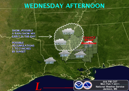
Winter Weather this week
NOTE: As always, it's difficult to accurately predict winter weather,
especially in the South. The information outlined below may change before
Wednesday. URGENT - WINTER WEATHER MESSAGE NATIONAL WEATHER SERVICE JACKSON MS 321 PM CST MON FEB 7 2011 ...WINTER STORM WATCH IN EFFECT FROM WEDNESDAY NOON THROUGH WEDNESDAY NIGHT FOR NORTHEAST LOUISIANA...SOUTHEAST ARKANSAS AND NORTHWEST MISSISSIPPI... .A COLD AIR MASS WILL MOVE IN BEHIND THE COLD FRONT THAT TRACKED ACROSS THE AREA TODAY. THIS COLD AIR MASS WILL REMAIN IN PLACE WHEN THE NEXT WEATHER SYSTEM MOVES IN DURING THE WEDNESDAY TO WEDNESDAY NIGHT TIME FRAME. THIS WILL RESULT IN THE POTENTIAL FOR SNOW FOR MUCH OF THE AREA WITH THE BEST POTENTIAL FOR ACCUMULATING SNOWFALL OVER NORTHEAST LOUISIANA...SOUTHEAST ARKANSAS AND NORTHWEST MISSISSIPPI THROUGH SUNRISE THURSDAY.
...WINTER STORM WATCH IN EFFECT FROM WEDNESDAY AFTERNOON THROUGH
LATE WEDNESDAY NIGHT...

THE NATIONAL WEATHER SERVICE IN JACKSON HAS ISSUED A WINTER STORM
WATCH...WHICH IS IN EFFECT FROM WEDNESDAY AFTERNOON THROUGH LATE
WEDNESDAY NIGHT.

* TIMING: SNOW WILL BEGIN TO ACCUMULATE OVER THE WATCH AREA
  WEDNESDAY AFTERNOON. SNOW FALL WILL INCREASE IN COVERAGE AND
  INTENSITY WEDNESDAY EVENING AND CONTINUE OVERNIGHT.

* MAIN IMPACT: SNOW ACCUMULATIONS OF 2 TO 4 INCHES ARE EXPECTED OVER
  THE AREA BY SUNRISE THURSDAY WITH HIGHER AMOUNTS POSSIBLE.

* OTHER IMPACTS: HAZARDOUS TRAVEL CONDITIONS ARE EXPECTED TO
  DEVELOP...ESPECIALLY ON BRIDGES AND ELEVATED ROAD SURFACES.
PRECAUTIONARY/PREPAREDNESS ACTIONS...

A WINTER STORM WATCH MEANS THERE IS A POTENTIAL FOR SIGNIFICANT
SNOW ACCUMULATIONS THAT MAY IMPACT TRAVEL. CONTINUE TO MONITOR THE
LATEST FORECASTS.

Friday, February 4, 2011
For Tonight 2/4/2011
All winter weather advisories, watches, and warnings have expired for our area. Here's the last graphic for this storm.


Bragging Rights
I recently discovered this audio clip of Col. Doug Wheelock aboard the International Space Station, recognizing my call sign (K5JAW) during an overpass of the United States on November 7, 2010. The ISS maintains an amateur radio station, and is on the air frequently. It's a challenge to have relatively weak earth-based signals heard aboard the ISS, orbiting about 200 miles above the surface of the earth. Of course, being that high, it's relatively easy to hear their signals. I've heard them on a number of previous passes, but this was my first confirmed contact.
Subscribe to:
Posts (Atom)