Watches, Warnings & Advisories for Sunflower Co.

Friday, August 31, 2012

Hazardous Weather Outlook: 31AUG12, Noon


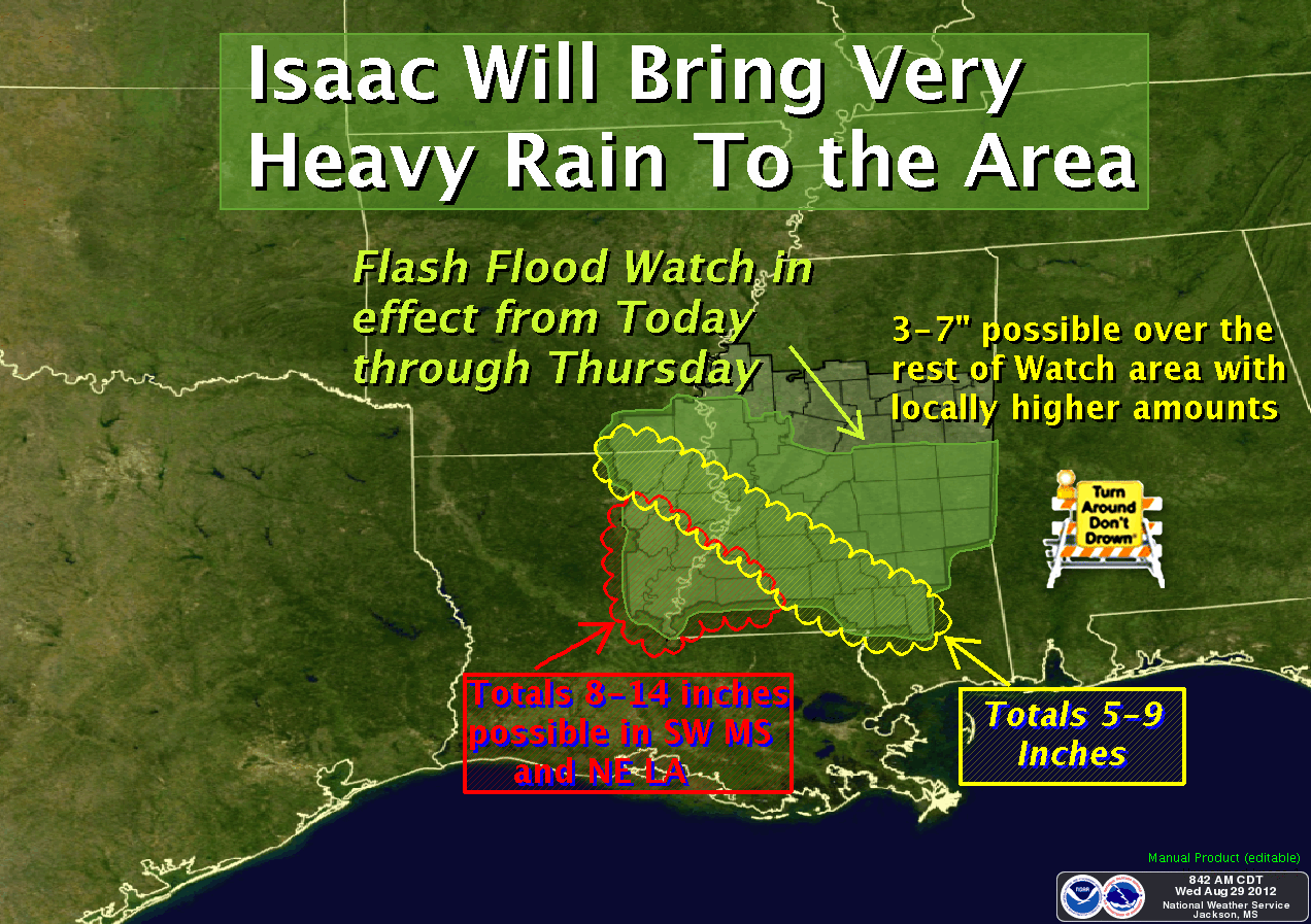
HAZARDOUS WEATHER OUTLOOK...UPDATED
NATIONAL WEATHER SERVICE JACKSON MS
1059 AM CDT FRI AUG 31 2012

GRENADA-CARROLL-MONTGOMERY-WEBSTER-CLAY-LOWNDES-CHOCTAW-OKTIBBEHA-
HOLMES-ATTALA-WINSTON-NOXUBEE-MADISON MS-LEAKE-NESHOBA-KEMPER-
HINDS-RANKIN-SCOTT-NEWTON-LAUDERDALE-COPIAH-SIMPSON-SMITH-JASPER-
CLARKE-LINCOLN-LAWRENCE-JEFFERSON DAVIS-COVINGTON-JONES-MARION-
LAMAR-FORREST-
1059 AM CDT FRI AUG 31 2012

THIS HAZARDOUS WEATHER OUTLOOK IS FOR MOST OF CENTRAL MISSISSIPPI
GENERALLY ALONG AND EAST OF INTERSTATE 55.

.DAY ONE...TODAY AND TONIGHT...THERE WILL BE THE POTENTIAL FOR
ISOLATED TORNADOES TODAY AS THE REMANANT OF ISSAC PUSHES INTO
MISSOURI TODAY. ADEQUATE WINDSHEAR...COMBINED WITH DAYTIME
HEATING...RESULTING IN SUFFICIENT INSTABILITY...WILL CAUSE STORMS TO
DEVELOP OVER THE AREA WHICH COULD PRODUCE ISOLATED TORNADOES THROUGH
EARLY THIS EVENING.

.DAYS TWO THROUGH SEVEN...SATURDAY THROUGH THURSDAY

THE PROBABILITY FOR WIDESPREAD HAZARDOUS WEATHER IS LOW.

.SPOTTER CALL TO ACTION STATEMENT...
THE ACTIVATION OF STORM SPOTTERS...HAM RADIO OPERATORS...AND
EMERGENCY MANAGEMENT PERSONNEL IN SUPPORT OF SEVERE WEATHER
OPERATIONS...MAY BE NEEDED THROUGH EARLY THIS EVENING.

$$

ASHLEY-CHICOT-MOREHOUSE-WEST CARROLL-EAST CARROLL-RICHLAND-
MADISON LA-FRANKLIN LA-CATAHOULA-TENSAS-CONCORDIA-BOLIVAR-
SUNFLOWER-LEFLORE-WASHINGTON-HUMPHREYS-ISSAQUENA-SHARKEY-YAZOO-
WARREN-CLAIBORNE-JEFFERSON-ADAMS-FRANKLIN MS-
1059 AM CDT FRI AUG 31 2012

THIS HAZARDOUS WEATHER OUTLOOK IS FOR SOUTHEAST ARKANSAS...NORTHEAST
LOUISIANA AND WESTERN PORTION OF CENTRAL MISSISSIPPI WEST OF
INTERSTATE 55.

.DAY ONE...TODAY AND TONIGHT
THERE WILL BE THE BETTER POTENTIAL FOR TORNADOES TODAY ACROSS THIS
AREA AS THE REMANANTS OF ISSAC PUSHES INTO MISSOURI TODAY. ADEQUATE
WINDSHEAR...COMBINED WITH DAYTIME HEATING...RESULTING IN SUFFICIENT
INSTABILITY...WILL CAUSE STORMS TO DEVELOP OVER THE AREA WHICH COULD
PRODUCE TORNADOES THROUGH EARLY THIS EVENING.

THERE WILL ALSO BE THE POTENTIAL FOR LOCALLY HEAVY RAINS AS BANDS OF HEAVY
RAINS PUSH NORTHWARD OVER THE REGION.  RAIN BANDS ASSOCIATED WITH ISAAC
WILL PIVOT ACROSS THE REGION BRINGING RAINFALL RATES OCCASIONALLY IN
EXCESS OF AN INCH PER HOUR...WHICH MAY CAUSE SOME LOCALIZED FLOODING.

.DAYS TWO THROUGH SEVEN...SATURDAY THROUGH THURSDAY

.SPOTTER CALL TO ACTION STATEMENT...
THE ACTIVATION OF STORM SPOTTERS...HAM RADIO OPERATORS...AND
EMERGENCY MANAGEMENT PERSONNEL IN SUPPORT OF SEVERE WEATHER
OPERATIONS...THROUGH EARLY THIS EVENING.


***DO NOT USE THIS WEBSITE AS YOUR SOLE SOURCE OF WEATHER INFORMATION, ESPECIALLY WATCHES AND WARNINGS. THIS WEBSITE DELIVERS FOCUSED INFORMATION FOR A SPECIFIC GEOGRAPHIC AREA AND IS NOT INTENDED TO PROVIDE TIMELY WEATHER WARNING INFORMATION***

Thursday, August 30, 2012

Rainfall Estimates

The graphic below is the rainfall estimate for the period between August 30 and September 1, superimposed onto a Google Earth map.  Remember, these are estimates.  Any given location may see slightly more, or less, than anticipated.

Beware of flash flooding and flooded areas.  Do not drive through flood waters!


***DO NOT USE THIS WEBSITE AS YOUR SOLE SOURCE OF WEATHER INFORMATION, ESPECIALLY WATCHES AND WARNINGS. THIS WEBSITE DELIVERS FOCUSED INFORMATION FOR A SPECIFIC GEOGRAPHIC AREA AND IS NOT INTENDED TO PROVIDE TIMELY WEATHER WARNING INFORMATION***

Hazardous Weather Outlook 11:15am 30 AUG 12

HAZARDOUS WEATHER OUTLOOK...UPDATED
NATIONAL WEATHER SERVICE JACKSON MS
1116 AM CDT THU AUG 30 2012

ASHLEY-CHICOT-BOLIVAR-SUNFLOWER-WASHINGTON-HUMPHREYS-HOLMES-
ATTALA-ISSAQUENA-SHARKEY-YAZOO-MADISON MS-LEAKE-NESHOBA-KEMPER-
SCOTT-NEWTON-LAUDERDALE-JASPER-CLARKE-
1116 AM CDT THU AUG 30 2012

THIS HAZARDOUS WEATHER OUTLOOK IS FOR EXTREME SOUTHEAST ARKANSAS AND
PORTIONS OF CENTRAL MISSISSIPPI.

.DAY ONE...TODAY AND TONIGHT

AS TROPICAL STORM ISAAC CONTINUES TO MOVE SLOWLY NORTHWEST OVER
NORTHEAST LOUISIANA TODAY...EXPECT GUSTY WINDS TO CONTINUE TO AFFECT
EXTREME SOUTHEAST ARKANSAS AND SOME CENTRAL PORTIONS OF THE ARKLAMISS
REGION. A WIND ADVISORY IN IS IN EFFECT FOR THESE LOCATIONS...AND
OCCASIONAL WIND GUSTS ABOVE 35 ARE POSSIBLE THROUGH AT LEAST LATE
TODAY. A FEW DEAD OR WEAK TREES MAY BE BLOWN DOWN THROUGH THE COURSE
OF TODAY...WITH SOME FALLING ONTO POWER LINES RESULTING IN POWER
OUTAGES.

A FLASH FLOOD WATCH IS IN EFFECT FOR MOST OF THESE AREAS AS HEAVY
RAIN IS EXPECTED TO CONTINUE THROUGH TODAY. RAIN BANDS ASSOCIATED
WITH ISAAC WILL PIVOT ACROSS THE REGION BRINGING RAINFALL RATES
OCCASIONALLY IN EXCESS OF AN INCH PER HOUR. THIS HEAVY RAIN WILL
EVENTUALLY RESULT IN FLASH FLOODING POTENTIAL.

IN ADDITION...THE POTENTIAL FOR TORNADOES WILL ALSO EXIST ACROSS THE
OUTLOOK AREA TODAY THROUGH THIS AFTERNOON. THIS RISK FOR TORNADOES
WILL BE GREATEST OVER AREAS ALONG AND EAST OF A GREENVILLE TO
BROOKHAVEN LINE.


.DAYS TWO THROUGH SEVEN...FRIDAY THROUGH WEDNESDAY

THE REMNANTS OF ISAAC WILL BE PULLING AWAY FROM OUR REGION INTO
NORTHERN ARKANSAS AND SOUTHERN MISSOURI TOMORROW NIGHT INTO FRIDAY.
LOCALLY HEAVY RAIN AND SOME GUSTY WINDS MAY PERSIST IN AT LEAST THE
ARKLAMISS DELTA THURSDAY EVENING...BUT SHOULD BE DIMINISHING A GREAT
DEAL BY FRIDAY.


.SPOTTER CALL TO ACTION STATEMENT...
THE ACTIVATION OF STORM SPOTTERS...HAM RADIO OPERATORS...AND
EMERGENCY MANAGEMENT PERSONNEL IN SUPPORT OF SEVERE WEATHER
OPERATIONS...WILL BE NEEDED THROUGH TONIGHT.

$$

MSZ025>033-038-039-311630-
LEFLORE-GRENADA-CARROLL-MONTGOMERY-WEBSTER-CLAY-LOWNDES-CHOCTAW-
OKTIBBEHA-WINSTON-NOXUBEE-
1116 AM CDT THU AUG 30 2012

THIS HAZARDOUS WEATHER OUTLOOK IS FOR NORTH CENTRAL AND NORTHEAST MISSISSIPPI.

.DAY ONE...TODAY AND TONIGHT

AS TROPICAL STORM ISAAC CONTINUES SLOWLY MOVING NORTHWEST OVER
NORTHEAST LOUISIANA...EXPECT LOCALLY HEAVY RAINS TO CONTINUE OVER
OVER NORTH CENTRAL AND NORTHEAST PORTIONS OF MISSISSIPPI...MAINLY
ALONG AND NORTH OF THE HIGHWAY 82 CORRIDOR. RAIN BANDS ASSOCIATED
WITH ISAAC WILL PIVOT ACROSS THE REGION MORE FREQUENTLY TODAY. THIS
HEAVY RAIN MAY EVENTUALLY RESULT IN THE PONDING OF WATER ON
ROADS...AS WELL AS IN LOW LYING AND POOR DRAINAGE AREAS THROUGH
TODAY.

IN ADDITION...THE POTENTIAL FOR TORNADOES WILL ALSO EXIST ACROSS THE
OUTLOOK AREA THROUGH THIS AFTERNOON. THIS RISK FOR TORNADOES WILL BE
GREATEST OVER AREAS ALONG AND EAST OF A GREENVILLE TO BROOKHAVEN
LINE.


.DAYS TWO THROUGH SEVEN...FRIDAY THROUGH WEDNESDAY

THE PROBABILITY OF WIDESPREAD HAZARDOUS WEATHER IS LOW.

.SPOTTER CALL TO ACTION STATEMENT...
THE ACTIVATION OF STORM SPOTTERS...HAM RADIO OPERATORS...AND
EMERGENCY MANAGEMENT PERSONNEL IN SUPPORT OF SEVERE WEATHER
OPERATIONS...WILL BE NEEDED TODAY.


***DO NOT USE THIS WEBSITE AS YOUR SOLE SOURCE OF WEATHER INFORMATION, ESPECIALLY WATCHES AND WARNINGS. THIS WEBSITE DELIVERS FOCUSED INFORMATION FOR A SPECIFIC GEOGRAPHIC AREA AND IS NOT INTENDED TO PROVIDE TIMELY WEATHER WARNING INFORMATION***

Hazardous Weather Outlook 30 AUG 12, 10:00am

Today will be a very active weather day as the remnants of Isaac pass to our west.  The current track is a bit more east than originally forecast, which means we have an increased risk of severe weather, tornadoes, and torrential rainfall today and tonight.

A TORNADO WATCH is in effect for Attala, Leflore, Montgomery, Holmes, Humphreys, and Carroll counties until 4:00pm

We can expect to see scattered downing of trees today, which can cause power outages.  Be prepared to deal with extended power outages, as power companies may not deploy personnel under extreme weather conditions.  Additionally, with the widespread damage in south Mississippi, power crews are extremely busy and it may take some time to restore power in your area.

Instead of starting with the Hazardous Weather Outlook text, I'll present this morning's graphics for you.  The HWO text follows.


HAZARDOUS WEATHER OUTLOOK
NATIONAL WEATHER SERVICE JACKSON MS
651 AM CDT THU AUG 30 2012

ASHLEY-CHICOT-BOLIVAR-SUNFLOWER-WASHINGTON-HUMPHREYS-HOLMES-
ATTALA-ISSAQUENA-SHARKEY-YAZOO-MADISON MS-LEAKE-NESHOBA-KEMPER-
SCOTT-NEWTON-LAUDERDALE-JASPER-CLARKE-
651 AM CDT THU AUG 30 2012

THIS HAZARDOUS WEATHER OUTLOOK IS FOR EXTREME SOUTHEAST ARKANSAS AND
PORTIONS OF CENTRAL MISSISSIPPI.

.DAY ONE...TODAY AND TONIGHT...

AS TROPICAL STORM ISAAC CONTINUES TO MOVE SLOWLY NORTHWEST AWAY FROM
THE COAST TODAY...EXPECT GUSTY WINDS TO CONTINUE TO AFFECT EXTREME
SOUTHEAST ARKANSAS AND SOME CENTRAL PORTIONS OF THE ARKLAMISS
REGION. A WIND ADVISORY IN IS IN EFFECT FOR THESE LOCATIONS...AND
OCCASIONAL WIND GUSTS ABOVE 35 ARE POSSIBLE THROUGH AT LEAST LATE
TODAY. A FEW DEAD OR WEAK TREES MAY BE BLOWN DOWN THROUGH THE COURSE
OF TODAY...WITH SOME FALLING ONTO POWER LINES RESULTING IN POWER OUTAGES.

A FLASH FLOOD WATCH IS IN EFFECT FOR MOST OF THESE AREAS AS HEAVY
RAIN IS EXPECTED TO CONTINUE THROUGH TODAY. RAIN BANDS ASSOCIATED
WITH ISAAC WILL PIVOT ACROSS THE REGION BRINGING RAINFALL RATES
OCCASIONALLY IN EXCESS OF AN INCH PER HOUR. THIS HEAVY RAIN WILL
EVENTUALLY RESULT IN FLASH FLOODING POTENTIAL.

IN ADDITION...THE POTENTIAL FOR TORNADOES WILL ALSO EXIST ACROSS THE
OUTLOOK AREA TODAY...ESPECIALLY FROM LATE THIS MORNING THROUGH THIS
AFTERNOON. THIS RISK FOR TORNADOES WILL BE GREATEST OVER AREAS ALONG
AND EAST OF A GREENVILLE TO BROOKHAVEN LINE.

.DAYS TWO THROUGH SEVEN...FRIDAY THROUGH WEDNESDAY...

THE REMNANTS OF ISAAC WILL BE PULLING AWAY FROM OUR REGION INTO
NORTHERN ARKANSAS AND SOUTHERN MISSOURI TOMORROW NIGHT INTO FRIDAY.
LOCALLY HEAVY RAIN AND SOME GUSTY WINDS MAY PERSIST IN AT LEAST THE
ARKLAMISS DELTA THURSDAY EVENING...BUT SHOULD BE DIMINISHING A GREAT
DEAL BY FRIDAY.

.SPOTTER CALL TO ACTION STATEMENT...
THE ACTIVATION OF STORM SPOTTERS...HAM RADIO OPERATORS...AND
EMERGENCY MANAGEMENT PERSONNEL IN SUPPORT OF SEVERE WEATHER
OPERATIONS WILL BE NEEDED THROUGH AT LEAST TONIGHT.
 
LEFLORE-GRENADA-CARROLL-MONTGOMERY-WEBSTER-CLAY-LOWNDES-CHOCTAW-
OKTIBBEHA-WINSTON-NOXUBEE-
651 AM CDT THU AUG 30 2012

THIS HAZARDOUS WEATHER OUTLOOK IS FOR PORTIONS OF NORTH CENTRAL
MISSISSIPPI...INCLUDING THE GOLDEN TRIANGLE AREA.

.DAY ONE...TODAY AND TONIGHT...

AS TROPICAL STORM ISAAC CONTINUES SLOWLY MORNING NORTHWEST AWAY FROM
THE COAST TODAY...EXPECT LOCALLY HEAVY RAINS TO GRADUALLY INCREASE OVER
NORTH CENTRAL PORTIONS OF MISSISSIPPI...MAINLY ALONG AND NORTH OF THE
HIGHWAY 82 CORRIDOR. RAIN BANDS ASSOCIATED WITH ISAAC WILL PIVOT
ACROSS THE REGION MORE FREQUENTLY TODAY. THIS HEAVY RAIN MAY
EVENTUALLY RESULT IN THE PONDING OF WATER ON ROADS...AS WELL AS IN
LOW LYING AND POOR DRAINAGE AREAS THROUGH TODAY.

IN ADDITION...THE POTENTIAL FOR TORNADOES WILL ALSO EXIST ACROSS THE
OUTLOOK AREA TODAY...ESPECIALLY FROM LATE THIS MORNING THROUGH THIS
AFTERNOON. THIS RISK FOR TORNADOES WILL BE GREATEST OVER AREAS ALONG
AND EAST OF A GREENVILLE TO BROOKHAVEN LINE.

.DAYS TWO THROUGH SEVEN...FRIDAY THROUGH WEDNESDAY...

THE PROBABILITY OF WIDESPREAD HAZARDOUS WEATHER IS LOW.

.SPOTTER CALL TO ACTION STATEMENT...
THE ACTIVATION OF STORM SPOTTERS...HAM RADIO OPERATORS...AND
EMERGENCY MANAGEMENT PERSONNEL IN SUPPORT OF SEVERE WEATHER
OPERATIONS...MAY BE NEEDED TODAY. 

***DO NOT USE THIS WEBSITE AS YOUR SOLE SOURCE OF WEATHER INFORMATION, ESPECIALLY WATCHES AND WARNINGS. THIS WEBSITE DELIVERS FOCUSED INFORMATION FOR A SPECIFIC GEOGRAPHIC AREA AND IS NOT INTENDED TO PROVIDE TIMELY WEATHER WARNING INFORMATION***

Wednesday, August 29, 2012

Hazardous Weather Outlook: 29-30 Aug 12

HAZARDOUS WEATHER OUTLOOK
NATIONAL WEATHER SERVICE JACKSON MS
416 PM CDT WED AUG 29 2012

ARZ074-075-MSZ034>037-040>046-050>052-057-058-302115-
ASHLEY-CHICOT-WASHINGTON-HUMPHREYS-HOLMES-ATTALA-ISSAQUENA-
SHARKEY-YAZOO-MADISON MS-LEAKE-NESHOBA-KEMPER-SCOTT-NEWTON-
LAUDERDALE-JASPER-CLARKE-
416 PM CDT WED AUG 29 2012

THIS HAZARDOUS WEATHER OUTLOOK IS FOR EXTREME SOUTHEAST ARKANSAS AND
PORTIONS OF CENTRAL AND EAST CENTRAL MISSISSIPPI.

.DAY ONE...TONIGHT AND THURSDAY

AS STRONG TROPICAL STORM ISAAC MOVES SLOWLY NORTHWEST AWAY FROM THE
COAST THROUGH TOMORROW EXPECT GUSTY WINDS TO AFFECT EXTREME SOUTHEAST
ARKANSAS AND SOME CENTRAL PORTIONS OF THE ARKLAMISS REGION. A
WIND ADVISORY IN IS IN EFFECT FOR THESE LOCATIONS...AND OCCASIONAL
WIND GUSTS ABOVE 35 ARE POSSIBLE THROUGH AT LEAST EARLY TOMORROW. A
FEW DEAD OR WEAK TREES MAY BE BLOWN DOWN BY LATER TONIGHT AFTER THE
GROUND BECOMES SATURATED.

A FLASH FLOOD WATCH IS IN EFFECT FOR MOST OF THESE AREAS AS HEAVY
RAIN IS EXPECTED TO CONTINUE THROUGH THURSDAY. RAIN BANDS ASSOCIATED
WITH ISAAC WILL PIVOT ACROSS THE REGION BRINGING RAINFALL RATES
OCCASIONALLY IN EXCESS OF AN INCH PER HOUR. THIS HEAVY RAIN WILL
EVENTUALLY RESULT IN AT LEAST ISOLATED FLASH FLOOD POTENTIAL.

IN ADDITION...THE POTENTIAL FOR BRIEF TORNADOES WILL EXPAND FROM
MAINLY SOUTHEASTERN MISSISSIPPI THIS AFTERNOON TO INCLUDE CENTRAL
MISSISSIPPI TONIGHT. THIS RISK WILL ENCOMPASS THE WHOLE OF THE AREA
ON THURSDAY...BUT WILL LIKELY TAPER OFF IN SOUTHEASTERN MISSISSIPPI
IN THE AFTERNOON HOURS.

.DAYS TWO THROUGH SEVEN...THURSDAY NIGHT THROUGH TUESDAY

THE REMNANTS OF ISAAC WILL BE PULLING AWAY FROM OUR REGION INTO
NORTHERN ARKANSAS AND SOUTHERN MISSOURI TOMORROW NIGHT INTO FRIDAY.
LOCALLY HEAVY RAIN AND SOME GUSTY WINDS MAY PERSIST IN AT LEAST THE
ARKLAMISS DELTA THURSDAY EVENING...BUT SHOULD BE DIMINISHING A GREAT
DEAL BY FRIDAY.

.SPOTTER CALL TO ACTION STATEMENT...
THE ACTIVATION OF STORM SPOTTERS...HAM RADIO OPERATORS...AND
EMERGENCY MANAGEMENT PERSONNEL IN SUPPORT OF SEVERE WEATHER
OPERATIONS...WILL BE NECESSARY THROUGH TOMORROW.

$$

MSZ018-019-025>033-038-039-302115-
BOLIVAR-SUNFLOWER-LEFLORE-GRENADA-CARROLL-MONTGOMERY-WEBSTER-CLAY-
LOWNDES-CHOCTAW-OKTIBBEHA-WINSTON-NOXUBEE-
416 PM CDT WED AUG 29 2012

THIS HAZARDOUS WEATHER OUTLOOK IS FOR PORTIONS OF NORTH CENTRAL
MISSISSIPPI...INCLUDING THE GOLDEN TRIANGLE.

.DAY ONE...TONIGHT AND THURSDAY

AS STRONG TROPICAL STORM ISAAC MOVES SLOWLY NORTHWEST AWAY FROM THE
COAST THROUGH TOMORROW EXPECT LOCALLY HEAVY RAINS TO GRADUALLY
INCREASE OVER NORTH CENTRAL PORTIONS OF MISSISSIPPI...MAINLY ALONG
AND NORTH OF THE HIGHWAY 82 CORRIDOR. RAIN BANDS ASSOCIATED WITH
ISAAC WILL PIVOT ACROSS THE REGION MORE FREQUENTLY LATE TONIGHT INTO
EARLY TOMORROW. THIS HEAVY RAIN MAY EVENTUALLY RESULT IN AT LEAST
A FEW PONDING OF WATER ISSUES BY LATE THURSDAY OR THURSDAY NIGHT.

IN ADDITION...THE POTENTIAL FOR BRIEF TORNADOES SHOULD EXPAND NORTH
INTO THE AREA TOMORROW.

.DAYS TWO THROUGH SEVEN...THURSDAY NIGHT THROUGH TUESDAY

THE REMNANTS OF ISAAC WILL BE PULLING AWAY FROM OUR REGION INTO
NORTHERN ARKANSAS AND SOUTHERN MISSOURI TOMORROW NIGHT INTO FRIDAY.
LOCALLY HEAVY RAIN AND SOME GUSTY WINDS MAY PERSIST IN AT LEAST THE
ARKLAMISS DELTA THURSDAY EVENING...BUT SHOULD BE DIMINISHING A GREAT
DEAL BY FRIDAY.

.SPOTTER CALL TO ACTION STATEMENT...
THE ACTIVATION OF STORM SPOTTERS...HAM RADIO OPERATORS...AND
EMERGENCY MANAGEMENT PERSONNEL IN SUPPORT OF SEVERE WEATHER
OPERATIONS...MAY BE NEEDED THROUGH TOMORROW.


***DO NOT USE THIS WEBSITE AS YOUR SOLE SOURCE OF WEATHER INFORMATION, ESPECIALLY WATCHES AND WARNINGS. THIS WEBSITE DELIVERS FOCUSED INFORMATION FOR A SPECIFIC GEOGRAPHIC AREA AND IS NOT INTENDED TO PROVIDE TIMELY WEATHER WARNING INFORMATION***

Health & Welfare

As I write this entry, I'm winding down a two-hour stint as the net control station for the Mississippi Emergency Net, established to handle health & welfare traffic from areas of the state affected by Hurricane Isaac.

In disasters, telephone circuits can become overloaded very quickly, provided they're not damaged by the emergency itself.  Cellular telephone systems are vulnerable to this overload as well.  In times when normal communications systems are unavailable, a tried-and-true system of passing messaged to loved ones remains available: amateur radio.

Amateur radio operators have the ability to link to other stations across the state and nation.  "Passing traffic", or relaying important messages for friends and family, is a core function of the amateur radio service.

If you live in an area affected by disaster and cannot contact friends and family outside of the area, you may find amateur radio stations set up at shelters and county emergency operations centers.  There, radio operators can assist you compose a telegram-like message, called a Radiogram, to send out of the area.

Examples of pre-formatted health & welfare messages include the following:

ARL-One: Everyone safe here.  Please don't worry
ARL-Two: Coming home as soon as possible
ARL-Three: Am in _____ hospital.  Receiving excellent care and recovering fine.
ARL-Four: Only slight property damage here.  Do not be concerned about disaster reports.

There are many more emergency-related pre-formatted messages, or you can format your own unique message to communicate your status and well-being to relatives.

You can also send Radiograms during non-emergency times.  Greetings for holidays, birthdays, or other special events can be sent in this old-fashioned, but proven method.

Amateur radio may seem like a quaint and somewhat antiquated hobby, but when other methods fail, you can depend on an amateur radio operator to pass your message along!

Hurricane Isaac #14, 29 AUG 12, 10:00AM

Hurricane Isaac continues to deluge southern Mississippi and southeast Louisiana with torrential rainfall as it slows down to a 6 mile-per-hour crawl in forward speed.  The forecast track for Isaac has shifted westward again, which hopefully improves the situation for Mississippi.

Forecast conditions for the Mississippi Delta have improved with this new forecast track.  Wind and rainfall estimates have continued to be revised downward.  Wind conditions across the Mississippi Delta through Thursday will consist of sustained 15-25mph winds with gusts of 35-45mph possible in some areas of the Detla.  Rainfall estimates now range from 1 to 4 inches, with the highest amounts expected in Washington and Humphreys counties and areas to the south.  A Flash Flood Watch is in effect for a large portion of central and south Mississippi, generally along the Highway 16 corridor counties from the Alabama line to Yazoo County, then northwestward to include Washington and Humphreys counties.

The risk for severe weather, including tornadoes, increases through Thursday as Isaac passes to our west.  


***DO NOT USE THIS WEBSITE AS YOUR SOLE SOURCE OF WEATHER INFORMATION, ESPECIALLY WATCHES AND WARNINGS. THIS WEBSITE DELIVERS FOCUSED INFORMATION FOR A SPECIFIC GEOGRAPHIC AREA AND IS NOT INTENDED TO PROVIDE TIMELY WEATHER WARNING INFORMATION***

Tuesday, August 28, 2012

Hurricane Isaac #13 28 AUG 12, 6:00pm

Isaac attained hurricane status this afternoon, and now holds 80 mile per hour sustained wind speeds near the center.  With Advisory #31 issued this afternoon, the projected tropical storm wind fields have contracted somewhat, excluding most of the Mississippi Delta.  While we will likely see sustained winds and occasionally higher gusts, the Delta shouldn't see sustained winds over 39mph.

As Isaac has changed, our expected rainfall totals have also gone down somewhat.  Please see the graphic below for expected rainfall totals between now and Saturday.  Please note, this graphic represents widespread rainfall totals...locally higher amounts could be seen.

Finally, the risk for severe weather, including tornadoes, increases as Isaac approaches through Thursday.  We will post Hazardous Weather Outlooks as they develop.


***DO NOT USE THIS WEBSITE AS YOUR SOLE SOURCE OF WEATHER INFORMATION, ESPECIALLY WATCHES AND WARNINGS. THIS WEBSITE DELIVERS FOCUSED INFORMATION FOR A SPECIFIC GEOGRAPHIC AREA AND IS NOT INTENDED TO PROVIDE TIMELY WEATHER WARNING INFORMATION***

Mississippi Amateur Radio info for Hurricane #Isaac

Emergency Net Information for Mississippi during Hurricane Isaac and its tropical storm aftermath.  Thanks to K1REZ for the information.

VHF Nets and Repeater Availability:
Florence Repeater: (146.760 77Hz tone) Priority and Emergency Traffic only from 2:00 pm Tuesday until returned to normal use (36-48+ hours)  Will be linked to repeaters all the way down to the gulf coast.

Raymond Repeater: (145.940 100Hz tone) SKYWARN traffic only 12:00 Noon Tuesday until returned to normal use (36-48+ hours) 

Brandon Repeater: (147.345 100H z tone) This repeater may be used for normal communications, unless the Rankin County ARES Team activates. Be prepared to relinquish the net.

Pelahatchie Repeater: (145.390 77Hz tone) This repeater may be used for normal communications, unless the Scott County ARES Team activates. Be prepared to relinquish the net.

Sharon Repeater: (145.440 77Hz tone) This repeater may be used for normal communications, unless the Madison County ARES Team activates. Be prepared to relinquish the net.

Jackson Repeater: 146.000 77Hz tone) This repeater may be used for normal communications, unless the Hinds County ARES Team activates it. Be prepared to relinquish the net.

HF Nets:

Hurricane Watch Net/ 14.325 (www.HWN.org)

The Mississippi Emergency Net will activate at 12:00 Noon CDST on Tuesday, August 28.  This is a joint operation between the Magnolia Section Net and the Mississippi Section Phone Net.  Daily operation will begin at 6:00 am and continue until 10:00 pm or later if activity warrants. The frequencies will be 7238 (day) and 3.862 (night).  The shift between bands will be at the discretion of the Net Manager and/or NCS.  This net will primarily handle Health-and-Welfare traffic and other issues related to Isaac.  A moratorium on inbound H/W traffic may be declared if it is obviously impossible to deliver the traffic due to storm damage. 

The Delta Division ARES EMCOMM Net will activate at 12:00 Noon on Tuesday, August 28, on a 24 Hour basis.  The frequencies will be 7.275 (day) and 3.890 (night).  The shift between bands will be at the
discretion of the Net Manager and/or NCS.  This net will primarily handle Tactical Traffic.  KM5EMA (MEMA) will be on this frequency beginning at 1:00 pm CDST. 

There may be periods on these Nets when there are relatively long period of silence.  Please help to keep the Net frequency clear.  If you wish to rag chew, please make arrangements and move off frequency. If a net frequency is in use by others tune either side to find the Hurricane Net operation. 

MEMA / RACES - If you are an active member of RACES and have a non-expired MEMA ID and can volunteer to man the radios at MEMA for a couple of hours please contact Jim Rapp WS7EOC 

Hinds County EOC
Has operators scheduled from 12:00-22:00 (Tuesday and from 08:00-13:00 Wednesday.  

Hancock County EOC
Ham Station Operators are needed at the Hancock County EOC in response to Isaac.  If you can help please contact Tom Kelly, AB6Z.

Isaac is expected to be a category 1 hurricane (not over 95 miles per hour) at its fastest. So folks up here in central Mississippi don't need to panic, but it is important to be prepared in central Mississippi for strong winds, heavy rains, flooding, mesocyclones and possible tornados. And the resulting loss of electricity and water for several days to a week and runs on gas stations and grocery stores.

Disaster Supply List

Each Saturday, we're updating a series of posts designed to help you build a disaster supply kit for your home.  You can find all the previous posts in that series by looking up our Disaster Preparedness tags, or by simply clicking here.

With Hurricane Isaac now at our doorstep, I've had requests to post the entire supply list.  You'll find that list outlined below.  If you want a printable version, click here.  Before making purchases, inventory your home as you likely have a number of the general supplies already available.

Remember to check back here each Saturday morning for a weekly "shopping list" of supplies.  You'll find it easier to make a series of small purchases along the way, as opposed to trying to buy everything at once.

www.K5JAW.com Disaster Supply List
**NOTE** For food products, this list is designed to supply one person for approximately FOUR
DAYS
. Multiply this for each additional person in your household, or for additional days.


Food Products (for each person)
  • 4 - Gallons of Water (one 24-count case of 16.9oz (500ml) bottled water contains three gallons)
  • 1 - Small Peanut Butter
  • 2 - Large cans fruit juice
  • 5 - Cans meat (can be chili, spaghetti, tuna, chicken, tamales, etc)
  • 4 - Cans fruit
  • 4 - Cans vegetables
  • 2 - Cans ready-to-eat soup

Food Products (bulk/boxed purchase)
  • Instant coffee, tea, powdered soft drinks
  • Quick energy snacks (nuts, raisins, granola bars, etc)
  • Graham crackers
  • Dry cereal

Food Storage
  • Assorted plastic containers with lids (for food storage)
  • Large plastic food bags
  • Plastic wrap
  • Aluminum foil

First Aid/Medical Supplies
  • Pain relief medication (aspirin, ibuprofen, acetaminophen)
  • Anti-diarrheal medication
  • Ipecac syrup and activated charcoal
  • Rubbing alcohol
  • Latex gloves
  • Compresses
  • Rolls of gauze or bandage
  • First aid tape
  • Adhesive bandages - assorted sizes
  • Scissors
  • Tweezers
  • Antiseptic
  • Thermometer
  • Liquid hand soap
  • Disposable hand wipes
  • Sewing kit
  • Feminine hygiene supplies

Tools
  • Crescent wrench
  • Heavy rope
  • Duct tape
  • Bungee cords
  • Crowbar
  • Pliers
  • Vise Grips
  • Masking tape
  • Hammer
  • Camping or utility knife
  • Heavy work gloves
  • Dust masks
  • Screwdriver
  • Safety goggles

General Supplies
  • Permanent marking pen
  • 2 flashlights and spare batteries (tip: try to use common battery sizes - what do you already use
  • at home...AA’s, C’s, etc?)
  • Toilet paper
  • Waterproof portable container for important documents
  • Portable AM/FM battery powered (or hand crank) radio
  • Paper towels
  • Whistle
  • Kleenex/tissues
  • Heavy duty garbage bags
  • Manual can opener (get two)
  • Camping lantern


TS Isaac #12 28 AUG 12 10:00AM

Tropical Storm Isaac continues to slowly move northwestward toward the Gulf Coast, with landfall expected to occur at or near the mouth of the Mississippi River tonight.  This morning's update indicates that wind fields for the Mississippi Delta will not be as extensive as was thought yesterday.  Rainfall estimates have also been reduced downward, with 3 to 5 inches possible across the Delta in the next 5 days.

Amateur Radio:
The Delta Division EMCOMM Net will activate at Noon, 1200hrs Central Time, on a 24-hour basis, on 7.275 MHz (day) and 3.890 MHz (night).  The shift between frequencies will be at the discretion of the Net Control Station.  This net will primarily handle tactical traffic.  KM5EMA, the station at the Mississippi State Emergency Operations Center, will be on frequency.

The Mississippi Emergency Net will activate at Noon, 1200hrs Central Time, on Tuesday, August 28.  Daily operation will begin at 0600hrs and end at 2200hrs or later if activity warrants.  Frequencies will be 7.238 MHz (day) and 3.862 (night), and Net Control will determine when to shift frequencies.  This net will handle Health-and-Welfare traffic and other Isaac-related issues.  A moratorium on inbound H/W traffic may be declared if it is obviously impossible to deliver the traffic due to storm damage.

The following report is centered on Washington County, Mississippi.

Storm Summary for Tropical Storm Isaac
Tuesday, August 28, 2012 at 10 AM CDT
(Output from Hurrevac, based on National Hurricane Center Forecast Advisory # 30)


Isaac is currently a tropical storm on the Saffir-Simpson Hurricane Wind Scale, with maximum sustained
winds of 70 mph (60 kts), moving northwest at 10 mph. The estimated minimum central pressure is 976
mb. Tropical storm-force winds extend outward up to 185 miles (295 km) from the storm center.

Wind Analysis for Washington, MS
(Based upon Tropical Storm Isaac Advisory #30)


Wind Probabilities
Jackson, MS, the closest reporting location, has within the 5-day forecast period of this advisory, a 1%
chance of at hurricane-force (64kt/74mph) winds, a 8% chance of at least strong tropical storm-force
(50kt/58mph) winds, and a 55% chance of at least tropical storm-force (34kt/39mph) winds.

Peak Wind*
Winds in Washington, MS are projected to peak at 34kt/39mph around 6:00 AM on Thursday, August 30,
2012

Wind Arrival and Duration*
Tropical storm-force winds (34kt/39mph) are forecast to begin in Washington, MS on Thursday, August
30, 2012 at 6:00 AM. Winds of this magnitude or higher are forecast to continue for 5 hours.
50kt/58mph winds are not forecast for Washington, MS.
64kt/74mph winds are not forecast for Washington, MS.

* These wind estimations are limited to the first 72 hours (3 days) following advisory issuance, and are
subject to considerable forecast uncertainty and generalization, especially if the storm is distant.
Maximum sustained winds (the highest surface wind maintained over a 1 minute period) are reported
here. Wind gusts and winds at higher elevations will be greater.

Estimated Wind Field distribution based on Advisory #30

Estimated Rainfall for Tuesday, August 28, based on Advisory #30
Estimated Rainfall for Wednesday, August 29, based on Advisory #30
Estimated Rainfall for Thursday, August 30, based on Advisory #30

***DO NOT USE THIS WEBSITE AS YOUR SOLE SOURCE OF WEATHER INFORMATION, ESPECIALLY WATCHES AND WARNINGS. THIS WEBSITE DELIVERS FOCUSED INFORMATION FOR A SPECIFIC GEOGRAPHIC AREA AND IS NOT INTENDED TO PROVIDE TIMELY WEATHER WARNING INFORMATION***

Hazardous Weather Outlook: 28 AUG 12 9:00AM

HAZARDOUS WEATHER OUTLOOK
NATIONAL WEATHER SERVICE JACKSON MS
535 AM CDT TUE AUG 28 2012
 
ARZ074-075-LAZ007>009-MSZ018-019-025>027-034>036-040>043-291045-
ASHLEY-CHICOT-MOREHOUSE-WEST CARROLL-EAST CARROLL-BOLIVAR-
SUNFLOWER-LEFLORE-GRENADA-CARROLL-WASHINGTON-HUMPHREYS-HOLMES-
ISSAQUENA-SHARKEY-YAZOO-MADISON MS-
535 AM CDT TUE AUG 28 2012
 
THIS HAZARDOUS WEATHER OUTLOOK IS FOR THE DELTA PORTION OF
MISSISSIPPI...EXTREME NORTHEAST LOUISIANA AND EXTREME SOUTHEAST
ARKANSAS.

.DAY ONE...TODAY AND TONIGHT

THE PROBABILITY OF WIDESPREAD HAZARDOUS WEATHER IS LOW.

.DAYS TWO THROUGH SEVEN...WEDNESDAY THROUGH MONDAY

TROPICAL STORM ISAAC IS EXPECTED TO INTENSIFY AND MAKE LANDFALL AS A
CATEGORY ONE HURRICANE OVER SOUTHEAST LOUISIANA THIS EVENING...AND
THEN MOVE SLOWLY NORTHWEST INTO SOUTHWEST MISSISSIPPI AND NORTHEAST
LOUISIANA THROUGH THURSDAY WHILE WEAKENING TO A TROPICAL STORM. AS A
RESULT...A VARIETY OF HAZARDOUS WEATHER CONDITIONS ARE EXPECTED TO
BEGIN OVERSPREADING THE AREA WEDNESDAY...CONTINUING INTO THURSDAY
AFTERNOON.

WIDESPREAD HEAVY RAINFALL IS LIKELY OVER MUCH OF THE AREA STARTING
WEDNESDAY MORNING CONTINUING THROUGH THURSDAY AFTERNOON. FLASH
FLOODING AND RIVER FLOODING WILL BE POSSIBLE. IN ADDITION...20 TO 30 MPH
WINDS WITH HIGHER GUSTS WILL OVERSPREAD THE OUTLOOK AREA WEDNESDAY
AFTERNOON...CONTINUING INTO THURSDAY MORNING. A FEW TORNADOES WILL
ALSO BE POSSIBLE ON WEDNESDAY AND THURSDAY.

WEATHER CONDITIONS WILL BEGIN TO IMPROVE BY FRIDAY AS THE STORM
SYSTEM PULLS AWAY TO THE NORTH.

.SPOTTER CALL TO ACTION STATEMENT...
THE ACTIVATION OF STORM SPOTTERS...HAM RADIO OPERATORS...AND
EMERGENCY MANAGEMENT PERSONNEL IN SUPPORT OF SEVERE WEATHER
OPERATIONS...WILL BE NEEDED WEDNESDAY INTO THURSDAY. 
 
MSZ028>033-037>039-044>046-050>052-291045-
MONTGOMERY-WEBSTER-CLAY-LOWNDES-CHOCTAW-OKTIBBEHA-ATTALA-WINSTON-
NOXUBEE-LEAKE-NESHOBA-KEMPER-SCOTT-NEWTON-LAUDERDALE-
535 AM CDT TUE AUG 28 2012

THIS HAZARDOUS WEATHER OUTLOOK IS FOR PORTIONS OF EAST CENTRAL
MISSISSIPPI.

.DAY ONE...TODAY AND TONIGHT

THE PROBABILITY OF WIDESPREAD HAZARDOUS WEATHER IS LOW.

.DAYS TWO THROUGH SEVEN...WEDNESDAY THROUGH MONDAY

TROPICAL STORM ISAAC IS EXPECTED TO INTENSIFY AND MAKE LANDFALL AS A
CATEGORY ONE HURRICANE OVER SOUTHEAST LOUISIANA THIS EVENING...AND
THEN MOVE SLOWLY NORTHWEST INTO SOUTHWEST MISSISSIPPI AND NORTHEAST
LOUISIANA THROUGH THURSDAY WHILE WEAKENING TO A TROPICAL STORM. AS A
RESULT...A VARIETY OF HAZARDOUS WEATHER CONDITIONS ARE EXPECTED TO
BEGIN OVERSPREADING THE AREA WEDNESDAY...CONTINUING INTO THURSDAY
AFTERNOON.

AREAS OF HEAVY RAINFALL WILL BE POSSIBLE OVER MUCH OF THE AREA
STARTING WEDNESDAY MORNING CONTINUING THROUGH THURSDAY AFTERNOON. IN
ADDITION...20 TO 25 MPH WINDS WITH HIGHER GUSTS WILL BE POSSIBLE
WEDNESDAY AFTERNOON...CONTINUING INTO WEDNESDAY NIGHT. A FEW
TORNADOES WILL ALSO BE POSSIBLE ON WEDNESDAY AND THURSDAY.

WEATHER CONDITIONS WILL BEGIN TO IMPROVE BY FRIDAY AS THE STORM
SYSTEM PULLS AWAY TO THE NORTH.

.SPOTTER CALL TO ACTION STATEMENT...
THE ACTIVATION OF STORM SPOTTERS...HAM RADIO OPERATORS...AND
EMERGENCY MANAGEMENT PERSONNEL IN SUPPORT OF SEVERE WEATHER
OPERATIONS...WILL BE NEEDED WEDNESDAY INTO THURSDAY. 

***DO NOT USE THIS WEBSITE AS YOUR SOLE SOURCE OF WEATHER INFORMATION, ESPECIALLY WATCHES AND WARNINGS. THIS WEBSITE DELIVERS FOCUSED INFORMATION FOR A SPECIFIC GEOGRAPHIC AREA AND IS NOT INTENDED TO PROVIDE TIMELY WEATHER WARNING INFORMATION***

Monday, August 27, 2012

TS Isaac #11 Hydrologic Outlook 27 AUG 12

HYDROLOGIC OUTLOOK
NATIONAL WEATHER SERVICE JACKSON MS
629 PM CDT MON AUG 27 2012

...TROPICAL STORM ISAAC EXPECTED TO PRODUCE MODERATE TO MAJOR FLOODING
 ACROSS SOUTH MISSISSIPPI AND MINOR TO MODERATE FLOODING IN CENTRAL MISSISSIPPI...

TROPICAL STORM ISAAC IS APPROACHING THE MISSISSIPPI AND SOUTHEAST
LOUISIANA COASTLINES. THE STORM IS EXPECTED TO BRING AN INFLUX OF
DEEP TROPICAL MOISTURE TO SOUTH MISSISSIPPI AS IT MOVES INLAND. HEAVY
RAINFALL WILL DEVELOP AS SOME OF THE OUTER FEEDER BANDS MOVE INTO
SOUTHEAST MISSISSIPPI ON TUESDAY AFTERNOON. ISAAC WILL MOVE INLAND
TUESDAY NIGHT NEAR THE MOUTH OF THE MISSISSIPPI RIVER AND WILL SLOWLY
MOVE TO SOUTHWEST MISSISSIPPI BY THURSDAY. THE SLOW MOVEMENT WILL
ENHANCE RAINFALL TOTALS ACROSS SOUTH AND PORTIONS OF CENTRAL
MISSISSIPPI. SOME HEAVY RAINFALL COULD ALSO BE POSSIBLE ACROSS
NORTHEAST LOUISIANA AND SOUTHEAST ARKANSAS AS THE SYSTEM PROGRESSES
INTO THE REGION. FLASH FLOODING AND SIGNIFICANT RIVER FLOODING ARE
PROBABLE.

RAINFALL TOTALS FROM 5 TO 10 INCHES WITH LOCALLY HEAVIER AMOUNTS
ARE POSSIBLE FROM TUESDAY NIGHT INTO WEDNESDAY NIGHT ACROSS SOUTH
MISSISSIPPI WITH AMOUNTS UP TO 15 INCHES POSSIBLE BY THE TIME THE
STORM MOVES OUT OF THE SOUTH. RAINFALL ACROSS CENTRAL MISSISSIPPI COULD
APPROACH 5 INCHES FROM WEDNESDAY MORNING TO THURSDAY MORNING WITH STORM
TOTALS APPROACHING FROM 8 TO 10 INCHES BY THE TIME THE STORM MOVES
OUT OF THIS AREA. OUR NORTHERN AREAS OF MISSISSIPPI CAN EXPECT
RAINFALL AMOUNTS FROM 4 TO 7 INCHES. RAINFALL AMOUNTS FROM 4 TO 7
INCHES ARE ALSO POSSIBLE ACROSS NORTHEAST LOUISIANA AND SOUTHEAST
ARKANSAS.

THIS COULD POSSIBLY BE THE MOST SIGNIFICANT TROPICAL RAINFALL EVENT TO
OCCUR ACROSS SOUTH MISSISSIPPI IN MANY YEARS. MODERATE TO MAJOR RIVER
FLOODING IS POSSIBLE ACROSS THE LOWER PEARL RIVER, LEAF RIVER,
TALLAHALA CREEK, AND POSSIBLY THE CHICKASAWHAY RIVER. MINOR TO
MODERATE FLOODING IS POSSIBLE ALONG THE HOMOCHITTO RIVER AS THE
SYSTEM MOVES NEAR THAT AREA ON THURSDAY. THE PEARL RIVER AND BIG
BLACK RIVERS IN CENTRAL MISSISSIPPI COULD SEE MINOR TO MODERATE
FLOODING. RIVERS IN NORTHEAST LOUISIANA AND SOUTHEAST ARKANSAS SHOULD
SEE SIGNIFICANT RISES AND COULD APPROACH MINOR FLOOD STAGE AS THE
SYSTEM MOVES NORTHWARD ON THURSDAY INTO FRIDAY. MINOR FLOODING IS
POSSIBLE ACROSS SOME OF THE YAZOO RIVER BASIN TRIBUTARIES. HEAVY
RAINFALL ALONG OUTER BANDS COULD CAUSE SIGNIFICANT RISES ALONG OUR
TOMBIGBEE TRIBUTARIES AS WELL.

THIS SYSTEM WARRANTS KEEPING A CLOSE WATCH FOR THOSE LIVING IN FLOOD
PRONE AREAS ACROSS THE SOUTHERN TWO THIRDS OF MISSISSIPPI, NORTHEAST
LOUISIANA, AND SOUTHEAST ARKANSAS.

***DO NOT USE THIS WEBSITE AS YOUR SOLE SOURCE OF WEATHER INFORMATION, ESPECIALLY WATCHES AND WARNINGS. THIS WEBSITE DELIVERS FOCUSED INFORMATION FOR A SPECIFIC GEOGRAPHIC AREA AND IS NOT INTENDED TO PROVIDE TIMELY WEATHER WARNING INFORMATION***

TS Isaac #10, 27 AUG 12 5:00pm

Little has changed with the 4:00pm update for Tropical Storm Isaac.  Mississippi can expect to see tropical storm force winds generally south of a Greenville - Meridian line.  In addition to sustained winds, heavy rainfall amounts could produce local flash flooding problems as well as flooding along rivers and streams that may last for several days.  Current projections indicate the Mississippi Delta could see over 6 inches of rainfall.  Graphics below depict the National Hurricane Center's current forecast, projected rainfall amounts, and the projected wind field distribution across south Mississippi.

The following is a report centered on Washington County, MS.  Neighboring counties can anticipate similar wind intensities and timing.

Storm Summary for Tropical Storm Isaac
Monday, August 27, 2012 at 4 PM CDT
(Output from Hurrevac, based on National Hurricane Center Forecast Advisory # 27)


Isaac is currently a tropical storm on the Saffir-Simpson Hurricane Wind Scale, with maximum sustained
winds of 70 mph (60 kts), moving northwest at 12 mph. The estimated minimum central pressure is 981
mb. Tropical storm-force winds extend outward up to 205 miles (335 km) from the storm center.

Certain coastal locations are under Hurricane Warning, Hurricane Watch, Tropical Storm Warning, and
Tropical Storm Watch as illustrated in the map below. The geographic extents of these watches and
warnings are detailed in the advisory text at the end of this report.

Wind Analysis for Washington County, MS
(Based upon Tropical Storm Isaac Advisory #27)


Wind Probabilities
Jackson, MS, the closest reporting location, has within the 5-day forecast period of this advisory, a 4%
chance of at hurricane-force (64kt/74mph) winds, a 16% chance of at least strong tropical storm-force
(50kt/58mph) winds, and a 66% chance of at least tropical storm-force (34kt/39mph) winds.

Peak Wind*
Winds in Washington, MS are projected to peak at 34kt/39mph around 7:00 AM on Thursday, August 30,
2012

Wind Arrival and Duration*
Tropical storm-force winds (34kt/39mph) are forecast to begin in Washington, MS on Thursday, August
30, 2012 at 7:00 AM. Winds of this magnitude or higher are forecast to continue for 10 hours.
50kt/58mph winds are not forecast for Washington, MS.
64kt/74mph winds are not forecast for Washington, MS.

* These wind estimations are limited to the first 72 hours (3 days) following advisory issuance, and are
subject to considerable forecast uncertainty and generalization, especially if the storm is distant.
Maximum sustained winds (the highest surface wind maintained over a 1 minute period) are reported
here. Wind gusts and winds at higher elevations will be greater.


***DO NOT USE THIS WEBSITE AS YOUR SOLE SOURCE OF WEATHER INFORMATION, ESPECIALLY WATCHES AND WARNINGS. THIS WEBSITE DELIVERS FOCUSED INFORMATION FOR A SPECIFIC GEOGRAPHIC AREA AND IS NOT INTENDED TO PROVIDE TIMELY WEATHER WARNING INFORMATION***

TS Isaac #9, 27 AUG 12 10:00AM

Tropical Storm Isaac continues to progress northwestward across the Gulf of Mexico.  While the forecast track has shifted slightly west again, residents in Mississippi will still see effects from the storm's passage.  Primarily, extended periods of heavy rain and high winds can be expected south of a line from roughly Greenville to Meridian.

The following information reflects expected conditions for Washington County, Mississippi.  The information regarding times and wind speeds will be roughly the same for the neighboring counties of Sharkey, Issaquena, Humphreys, and extreme southern Sunflower.

Storm Summary for Tropical Storm Isaac
Monday, August 27, 2012 at 10 AM CDT
(Output from Hurrevac, based on National Hurricane Center Forecast Advisory # 26)


Isaac is currently a tropical storm on the Saffir-Simpson Hurricane Wind Scale, with maximum sustained
winds of 65 mph (55 kts), moving northwest at 14 mph. The estimated minimum central pressure is 988
mb. Tropical storm-force winds extend outward up to 205 miles (335 km) from the storm center.

Wind Analysis for Washington, MS
(Based upon Tropical Storm Isaac Advisory #26)


Wind Probabilities
Jackson, MS, the closest reporting location, has within the 5-day forecast period of this advisory, a 4%
chance of at hurricane-force (64kt/74mph) winds, a 17% chance of at least strong tropical storm-force
(50kt/58mph) winds, and a 57% chance of at least tropical storm-force (34kt/39mph) winds.

Peak Wind*
Winds in Washington, MS are projected to peak at 36kt/41mph around 9:00 AM on Thursday, August 30,
2012

Wind Arrival and Duration*
  • Tropical storm-force winds (34kt/39mph) are forecast to begin in Washington, MS on Wednesday,
  • August 29, 2012 at 7:00 PM. Winds of this magnitude or higher are forecast to continue for 15 hours.
  • 50kt/58mph winds are not forecast for Washington, MS.
  • 64kt/74mph winds are not forecast for Washington, MS.
* These wind estimations are limited to the first 72 hours (3 days) following advisory issuance, and are
subject to considerable forecast uncertainty and generalization, especially if the storm is distant.
Maximum sustained winds (the highest surface wind maintained over a 1 minute period) are reported
here. Wind gusts and winds at higher elevations will be greater.

Preparedness Ideas:
  • Maintain at least a half-tank of gas in your vehicle until the storm is well past our area.
  • Have water and ready-to-eat food available to supply your family for at least three days (5 to 7 days is better).
  • Water needs = 1 gallon per person, per day.  A 24-count case of 16.9oz bottled water contains 3 gallons, enough for three days for one person.
  • Verify out-of-state contacts to communicate with.  Sometimes local phone service may be affected, while long distance remains available.


***DO NOT USE THIS WEBSITE AS YOUR SOLE SOURCE OF WEATHER INFORMATION, ESPECIALLY WATCHES AND WARNINGS. THIS WEBSITE DELIVERS FOCUSED INFORMATION FOR A SPECIFIC GEOGRAPHIC AREA AND IS NOT INTENDED TO PROVIDE TIMELY WEATHER WARNING INFORMATION***

Sunday, August 26, 2012

TS Isaac #8 26 AUG 12

The 4:00pm update for Tropical Storm Isaac continues to shift the projected landfall to the west.  Currently, the anticipated landfall will occur Wednesday, August 29, near the Bay of Saint Louis in Mississippi.  Forecasters anticipate that Isaac will intensify in the Gulf of Mexico over the next 36 to 60 hours to a Category-2 strength hurricane (winds 96-110 MPH with 6-8 foot storm surge).  While the official forecast track from the National Hurricane Center shows landfall in Mississippi, model guidance varies widely from the Texas/Louisiana border in the west, to near Pensacola, FL in the east.

Impacts to Mississippi will vary, depending on the final path of Isaac.  Storms passing to our east will generally result in widespread wind and rain for Mississippi.  Storms falling to our west could result in coastal flooding along with very heavy rains and storms for eastern Mississippi, including the possibility of flash flooding in some areas.

Again, the key point to remember is not to focus on a single forecast track.  If you live in the error cone, your are at risk.

Amateur Radio interests:
The Hurricane Watch Net is active on 14.325 MHz and 7.268 MHz.
Mississippi Section Phone Net: 3.862 MHz
Central Gulf Coast Hurricane Net: 3.935 Mhz

Forecast maps from the 4:00pm update:


***DO NOT USE THIS WEBSITE AS YOUR SOLE SOURCE OF WEATHER INFORMATION, ESPECIALLY WATCHES AND WARNINGS. THIS WEBSITE DELIVERS FOCUSED INFORMATION FOR A SPECIFIC GEOGRAPHIC AREA AND IS NOT INTENDED TO PROVIDE TIMELY WEATHER WARNING INFORMATION***

Sunday's tropical update delayed

Forecast models and maps have varied wildly over the last 12 hours.  As such, I'm not going to provide a complete morning update.  I'll let the forecasters look over the data today, and will post an update this evening.

The key is to not focus on a single track.  If you're in the error cone, you're at risk.  If you're caught off guard by this storm....well, it's your decision.

Having said that, here's this morning's NHC map:

***DO NOT USE THIS WEBSITE AS YOUR SOLE SOURCE OF WEATHER INFORMATION, ESPECIALLY WATCHES AND WARNINGS. THIS WEBSITE DELIVERS FOCUSED INFORMATION FOR A SPECIFIC GEOGRAPHIC AREA AND IS NOT INTENDED TO PROVIDE TIMELY WEATHER WARNING INFORMATION***

Saturday, August 25, 2012

TS Isaac #7 25 AUG 12

This morning's forecast from the National Hurricane Center continues to show landfall for TS Isaac along the Florida panhandle.  Various computer models still aren't in complete agreement though, with predictions ranging from the mouth of the Mississippi River in the west, to the Big Bend of Florida in the east.

As we've said before, the key is to not focus on a single track line, but consider the range of possibilities as Isaac continues to develop.  Some forecasters think that by the time Isaac makes landfall on the northern Gulf Coast, it could be a Category 2 hurricane.

Here are the maps from this morning's forecast and model runs:


***DO NOT USE THIS WEBSITE AS YOUR SOLE SOURCE OF WEATHER INFORMATION, ESPECIALLY WATCHES AND WARNINGS. THIS WEBSITE DELIVERS FOCUSED INFORMATION FOR A SPECIFIC GEOGRAPHIC AREA AND IS NOT INTENDED TO PROVIDE TIMELY WEATHER WARNING INFORMATION***

Disaster Preps: Week 9

This week's list is short and sweet!

Weekly Purchases: (items with * should be purchased for every family member)

  • 1 can of ready-to-eat soup*
  • Liquid dish soap
  • Plain liquid bleach (unscented)
  • Heavy duty garbage bags
Action Items:
  • Copy or digitally scan favorite family photos and send to out-of-state relatives for safe keeping.  If you have a wealth of digital photographs, consider purchasing a portable backup solution such as a portable hard drive.
  • Research data backup plans so that you can recover vital data after an emergency, or computer crash.

Friday, August 24, 2012

TS Isaac #6, 24 AUG 12

The 4:00PM National Hurricane Center forecast has moved Tropical Storm Isaac back to the east away from the Mobile, AL/MS state line to the Destin, FL area with landfall occurring sometime Tuesday.  However, with some 96 hours between now and then, more changes in the forecast track can be expected.  Be prudent and do not focus on a single track forecast.  Rely on the error cone, as the storm can still affect any area contained in that cone.

The Hurricane Watch Net on 14.325 MHz has been suspended for now, but may reactivate either tonight or tomorrow morning.  Click the link for information on the status of the net.

Here are the 4:00pm maps and models


***DO NOT USE THIS WEBSITE AS YOUR SOLE SOURCE OF WEATHER INFORMATION, ESPECIALLY WATCHES AND WARNINGS. THIS WEBSITE DELIVERS FOCUSED INFORMATION FOR A SPECIFIC GEOGRAPHIC AREA AND IS NOT INTENDED TO PROVIDE TIMELY WEATHER WARNING INFORMATION***

TS Isaac #5, 24 AUG 12

While the forecast models seem to have drifted back to the east, the National Hurricane Center's forecast hasn't changed much.  You'll notice a few of the models still show a western movement.  Again, the key here is not to focus on any single line or point on the maps.  Monitor this storm's forecast progression carefully over the weekend.  With all that said, if the storm stays to the east of Mississippi, we will experience adverse tropical weather..  However, if the forecast moves the storm more to our west, we can expect a more severe impact than an eastward-passing storm.

It is advisable for not only coastal residents but inland residents to check their family emergency plans and supplies.  Tropical storms & hurricanes continue to produce torrential rains and storms well inland, and can cause widespread damage and power outages.

Over the weekend, make sure you have at least three days' supply of food and water for you and your family (one gallon of water per person, per day).  Contact friends or family where you may evacuate out of the potential affected area if needed.  When your area is within 96 to 72 hours being affected by tropical storm force winds, maintain fuel levels at or above a half-tank in your vehicle.  With your family, determine what conditions or situations would necessitate your evacuation.  It's always better to be ahead of the evacuation crowd.

Here are this morning's forecast maps.  I'll update them again later this afternoon.


***DO NOT USE THIS WEBSITE AS YOUR SOLE SOURCE OF WEATHER INFORMATION, ESPECIALLY WATCHES AND WARNINGS. THIS WEBSITE DELIVERS FOCUSED INFORMATION FOR A SPECIFIC GEOGRAPHIC AREA AND IS NOT INTENDED TO PROVIDE TIMELY WEATHER WARNING INFORMATION***

Thursday, August 23, 2012

TS Isaac #4, 23 AUG 12

Here are the latest NHC forecast and computer model graphics.  The key here is to not focus on a single line on the map.  There are many days yet before we could see any effects of this storm, and many more forecasts and models to run.  Be prudent, monitor the developments carefully.  Use the weekend to review your family's plans and supplies.


***DO NOT USE THIS WEBSITE AS YOUR SOLE SOURCE OF WEATHER INFORMATION, ESPECIALLY WATCHES AND WARNINGS. THIS WEBSITE DELIVERS FOCUSED INFORMATION FOR A SPECIFIC GEOGRAPHIC AREA AND IS NOT INTENDED TO PROVIDE TIMELY WEATHER WARNING INFORMATION***

TS Isaac #3, 23 Aug 12

Updating graphics from this morning.  Forecast models and the official forecast have shifted slightly to the west, meaning that Mississippi may have a higher chance of being affected next week, with most forecasters agreeing that Isaac will intensify into a hurricane once in the Gulf of Mexico.

The key at this point is to not focus on a black line on the map.  Anyone in the "error cone" area should pay close attention to the future forecasts.  The lower map represents the chance of any area experiencing tropical storm force winds through Tuesday, August 28. 

The Hurricane Watch Net stated they would activate today, August 23, at 3:00pm on 14.325 MHz, with 7.268 MHz and 3.950 MHz as backup frequencies.  Other nets to monitor:
  • Central Gulf Coast Hurricane Net - 3.935 MHz
  • Gulf Coast SSB Net - 3.925 MHz
  • Mississippi Section Phone Net - 3.862 MHz


***DO NOT USE THIS WEBSITE AS YOUR SOLE SOURCE OF WEATHER INFORMATION, ESPECIALLY WATCHES AND WARNINGS. THIS WEBSITE DELIVERS FOCUSED INFORMATION FOR A SPECIFIC GEOGRAPHIC AREA AND IS NOT INTENDED TO PROVIDE TIMELY WEATHER WARNING INFORMATION***

TS Isaac #2, 23 AUG 12

**Graphics updated to reflect 11:00AM NHC Forecast**

Tropical Storm Isaac continues to track westerly across the Caribbean as forecast modeling begins to shift landfall to the Florida panhandle and increase the threat to the eastern Gulf of Mexico.

If you're vacationing, or have plans to visit the west coast of Florida, the Panhandle, or other areas east of Mobile,  you will want to pay close attention to forecasts for Isaac.

Take time this weekend to review your family's emergency plans.  If you are on vacation, consult with your hotel or condominium staff about local emergency and evacuation plans.  It's always better to be ahead of the crowd if evacuations become necessary.

Daily updates regarding Tropical Storm Isaac will continue on this website until it no longer represents a threat to Mississippi.  Other information can be found by visiting the following websites:
For those in the Amateur Radio Community, the National Hurricane Center WX4NHC will be activated on Friday, August 24, on primary frequency 14.325 MHz, secondary frequencies 7.368 and 3.950 MHz, and on VOIP WXNet.

Here are this morning's forecast maps:


***DO NOT USE THIS WEBSITE AS YOUR SOLE SOURCE OF WEATHER INFORMATION, ESPECIALLY WATCHES AND WARNINGS. THIS WEBSITE DELIVERS FOCUSED INFORMATION FOR A SPECIFIC GEOGRAPHIC AREA AND IS NOT INTENDED TO PROVIDE TIMELY WEATHER WARNING INFORMATION***

Wednesday, August 22, 2012

Tropical Storm Isaac #1 22 AUG 12

Tropical Storm Isaac has formed in the eastern Caribbean and has gained intensity overnight.  While TS Isaac is many days away from affecting the United States, residents along the Gulf of Mexico and the Atlantic coast should monitor this storm closely.  NOTE: Forecast and model graphics can be found at the end of this entry.

This morning's official forecast from the National Hurricane Center indicates that TS Isaac will affect the south Florida coast late Sunday into Monday of next week.  This forecast reflects the consensus of most computer models.  However, one model places Isaac in the central Gulf of Mexico next Tuesday as a hurricane.  Bear in mind that there are numerous variables that affect the model predictions and the storm's ultimate path.  No single model or forecast track should be considered as final.  Therefore, residents are encouraged to use the time available to check their family preparedness plans and supplies.

Here are a few preparedness tips for you to consider as Isaac develops:
  • Check and update food & water supplies for your family (minimum of 3 days worth)
  • Review local and state evacuation routes
  • Determine evacuation location alternatives (friends, family outside the potential affected areas)
  • Establish contact with those locations
  • Establish an out-of-state point of contact
  • Maintain fuel levels above a half-tank in your cars
  • Set your own evacuation decision triggers.  It's better to be ahead of the crowd!
For my friends in the Amateur Radio community, take advantage of the fair weather we're experiencing to check your station equipment and antennas.  The Hurricane Watch Net is currently on standby for activation, and will be found on 14.325 MHz USB when they activate.  Amateur Radio stations in Mississippi may access our Section Emergency Plan at www.arrlmiss.org.  Other HF nets of interest to the southeastern United States are:
  • Mississippi Section Phone Net, 3862 kHz (night) and/or 7238 kHz (day)
  • Delta Division: 3890 kHz (night) and 7275 kHz (day) (active in regional emergencies)
  • MS-STEX-LA: 3873 kHz (night) and 7280 kHz (day) (active in regional emergencies)
  • Gulf Coast Sideband Net: 3925 kHz
  • Maritime Mobile Net: 14.300 MHz
  • Caribbean Emergency Weather Net: 3813 kHz
A listing of Caribbean regional emergency nets can be found by clicking here.
Here's the latest NHC forecast map, followed by a map depicting the various model tracks.


***DO NOT USE THIS WEBSITE AS YOUR SOLE SOURCE OF WEATHER INFORMATION, ESPECIALLY WATCHES AND WARNINGS. THIS WEBSITE DELIVERS FOCUSED INFORMATION FOR A SPECIFIC GEOGRAPHIC AREA AND IS NOT INTENDED TO PROVIDE TIMELY WEATHER WARNING INFORMATION***

Saturday, August 18, 2012

Disaster Preps: Week 8

More first aid supplies will be on our list this week.

Weekly Purchases:
  • Scissors
  • Tweezers
  • Antiseptic
  • Thermometer
  • Liquid hand soap or hand sanitizer
  • Disposable hand wipes
  • Sewing kit
  • Extra eyeglasses, if needed.
Action Items:
  • Keep a pair of shoes and a flashlight under your bed for quick access if needed at night.

Friday, August 17, 2012

Hazardous Weather Outlook 17 Aug 2012

HAZARDOUS WEATHER OUTLOOK...UPDATED
NATIONAL WEATHER SERVICE JACKSON MS
545 AM CDT FRI AUG 17 2012

THIS HAZARDOUS WEATHER OUTLOOK IS FOR EXTREME SOUTHEASTERN ARKANSAS
AND PORTIONS OF NORTHEASTERN LOUISIANA AND CENTRAL MISSISSIPPI ALONG
AND NORTH OF THE INTERSTATE TWENTY CORRIDOR.

.DAY ONE...TODAY AND TONIGHT

STRONG TO SEVERE STORMS ARE POSSIBLE THROUGH THE MORNING HOURS
EXTENDING ALONG AND NORTH OF A PORT GIBSON MISSISSIPPI TO LAUREL
MISSISSIPPI LINE. THE MOST INTENSE STORMS COULD CONTAIN WIND GUSTS
OF 40 TO 60 MPH AS WELL HAIL FROM DIME TO QUARTER SIZE. STORMS
WILL BE CAPABLE OF PRODUCING FREQUENT LIGHTNING STRIKES AND HEAVY
DOWNPOURS.

REDEVELOPMENT OF STRONG TO SEVERE STORMS COULD OCCUR THIS AFTERNOON
AS THE AIRMASS RECOVERS FROM THE MORNING ACTIVITY. THERE IS STILL
SOME QUESTION AS TO THE AMOUNT OF RECOVERY...HOWEVER. WIND GUSTS OF
50 TO 60 MPH...DIME TO QUARTER HAIL...AND HEAVY RAINFALL POSING A
FLASH FLOODING RISK COULD BE POSSIBLE.

.DAYS TWO THROUGH SEVEN...SATURDAY THROUGH THURSDAY

STRONG TO SEVERE STORMS WILL CONTINUE TO BE POSSIBLE INTERMITTENTLY
SATURDAY AND SUNDAY...ESPECIALLY ALONG AND SOUTH OF THE
INTERSTATE TWENTY CORRIDOR...AS AN ACTIVE WEATHER PATTERN PERSISTS.
THE MOST INTENSE STORMS COULD CONTAIN WIND GUSTS UP TO 60 MPH AS
WELL AS HAIL UP TO THE SIZE OF QUARTERS. MANY STORMS WILL AGAIN BE
CAPABLE OF PRODUCING FREQUENT LIGHTNING STRIKES AND HEAVY DOWNPOURS.

IN ADDITION...ISOLATED RAINFALL TOTALS FROM TODAY THROUGH THE
WEEKEND WILL LIKELY BE UP TO OR GREATER THAN 2 INCHES. IN A FEW
LOCATIONS THIS COULD LEAD TO MINOR FLOODING PROBLEMS...ALTHOUGH
WIDESPREAD FLOODING ISSUES ARE NOT ANTICIPATED AT THIS TIME.

.SPOTTER CALL TO ACTION STATEMENT...
THE ACTIVATION OF STORM SPOTTERS...HAM RADIO OPERATORS...AND
EMERGENCY MANAGEMENT PERSONNEL IN SUPPORT OF SEVERE WEATHER
OPERATIONS...MAY BE NEEDED AT TIMES THROUGH AT LEAST SATURDAY.


***DO NOT USE THIS WEBSITE AS YOUR SOLE SOURCE OF WEATHER INFORMATION, ESPECIALLY WATCHES AND WARNINGS. THIS WEBSITE DELIVERS FOCUSED INFORMATION FOR A SPECIFIC GEOGRAPHIC AREA AND IS NOT INTENDED TO PROVIDE TIMELY WEATHER WARNING INFORMATION***