There are two items worthy of note as we consider our first chance of winter weather for the year:
- The forecast is uncertain. Forecasters believe that conditions for sleet/freezing rain are marginal at best. Temperature variations of just a few degrees mean the difference in rain and freezing rain.
- Take the opportunity today to gather a few day's supply of food and water for your household. There's no indication of a major winter storm in the forecast, but Mississippi winter weather can be fickle! You can find a sample list of supplies in an article we published earlier concerning disaster preparations by clicking here for the article.
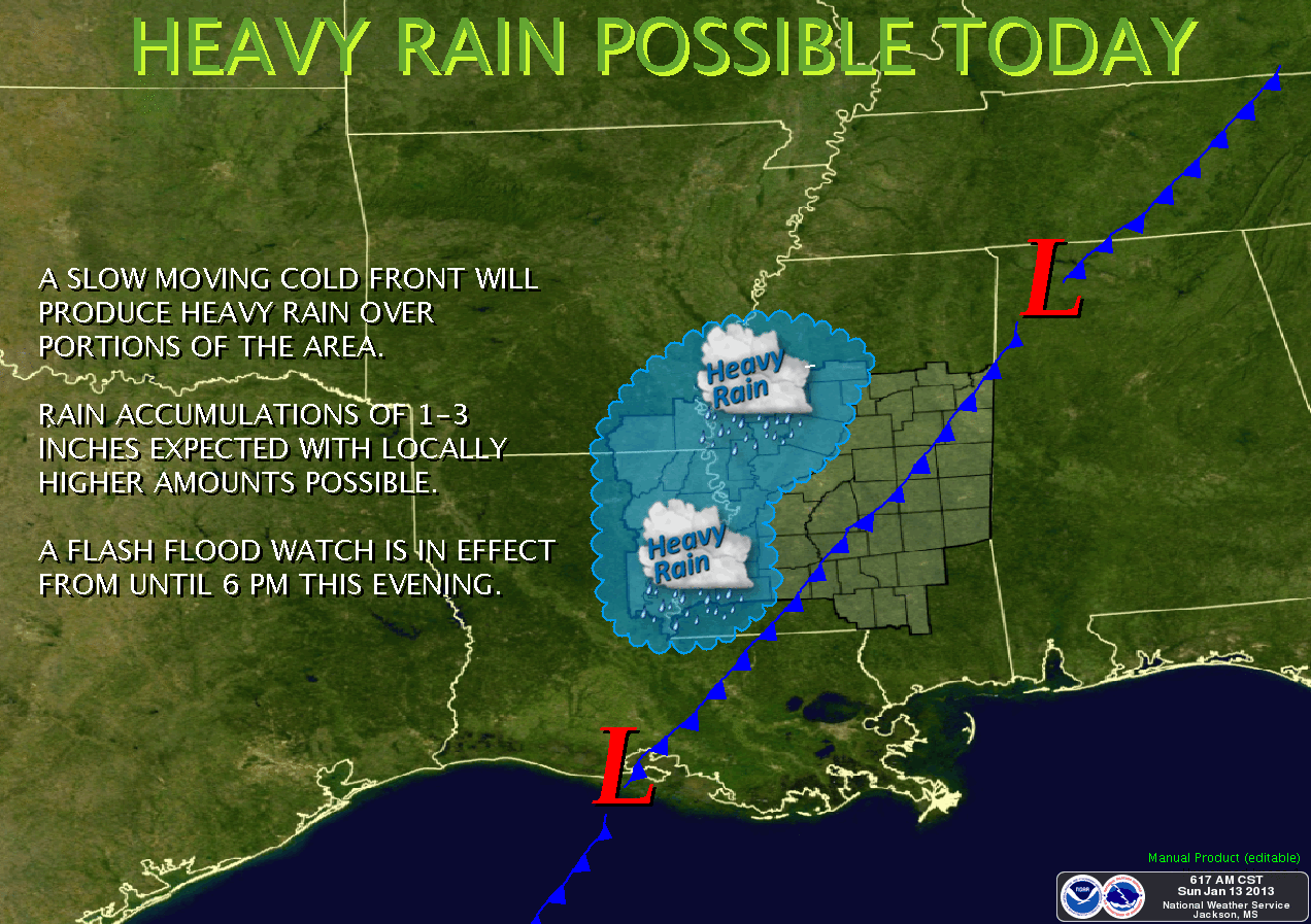
FLASH FLOOD WATCH for the entire Delta area for the remainder of the day.
FLOOD WARNING for the Sunflower River at Sunflower, MS (Sunflower County)
FLOOD WARNING for the Yalobusha River at Whaley, MS (Carroll & Leflore counties)
FLOOD WARNING for the Big Black River (Attala & Holmes counties)
HAZARDOUS WEATHER OUTLOOK
NATIONAL WEATHER SERVICE JACKSON MS
504 AM CST SUN JAN 13 2013

THIS HAZARDOUS WEATHER OUTLOOK IS FOR CENTRAL MISSISSIPPI...
NORTHEAST LOUISIANA...AND EXTREME SOUTHEAST ARKANSAS.

.DAY ONE...TODAY AND TONIGHT

HEAVY RAINFALL FROM SHOWERS AND THUNDERSTORMS WILL BE ON THE
INCREASE AS A SLOW COLD FRONT MOVES THROUGH THE REGION TODAY.
RAINFALL AMOUNTS OF 1 TO 3 INCHES CAN BE EXPECTED WITH LOCALLY
HIGHER AMOUNTS POSSIBLE. A FLASH FLOOD WATCH CONTINUES THROUGH
THIS AFTERNOON. STANDING WATER PERSISTS IN SOME AREAS FROM
HEAVY RAINFALL THAT OCCURRED EARLIER THIS WEEK. FLOODING PROBLEMS
WILL BE ENHANCED BY SATURATED SOIL CONDITIONS ACROSS THE AREA.

.DAYS TWO THROUGH SEVEN...MONDAY THROUGH SATURDAY

THERE WILL BE A POTENTIAL FOR RAIN TO CHANGE TO FREEZING RAIN AND SOME
POSSIBLE SLEET ACROSS PARTS OF THE DELTA REGION EARLY MONDAY
MORNING. COLD AIR WILL MOVE INTO PLACE BEHIND THE COLD FRONT
WHILE A GOOD CHANCE FOR PRECIPITATION CONTINUES ACROSS THE REGION.
THIS WILL MAINTAIN A CHANCE FOR PERIODS OF FREEZING RAIN OR SLEET
THROUGH EARLY WEDNESDAY MORNING. CONDITIONS WILL BE MARGINAL FOR THE
MINIMUM REQUIREMENTS FOR WINTER WEATHER DEVELOPMENT AND A CHANGE OF
A DEGREE OR TWO WILL MEAN THE DIFFERENCE BETWEEN FREEZING RAIN AND
JUST A COLD RAIN. PLEASE STAY TUNED TO LATER FORECASTS FOR MORE
SPECIFIC INFORMATION ON THIS DEVELOPING SITUATION.

.SPOTTER CALL TO ACTION STATEMENT...
THE ACTIVATION OF STORM SPOTTERS...HAM RADIO OPERATORS...AND
EMERGENCY MANAGEMENT PERSONNEL IN SUPPORT OF SEVERE WEATHER
OPERATIONS WILL NOT BE NEEDED.

***DO NOT USE THIS WEBSITE AS YOUR SOLE SOURCE OF WEATHER INFORMATION, ESPECIALLY WATCHES AND WARNINGS. THIS WEBSITE DELIVERS FOCUSED INFORMATION FOR A SPECIFIC GEOGRAPHIC AREA AND IS NOT INTENDED TO PROVIDE TIMELY WEATHER WARNING INFORMATION***
No comments:
Post a Comment